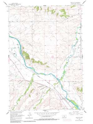
Greycliff Topo Map Montana
To zoom in, hover over the map of Greycliff
USGS Topo Quad 45109g7 - 1:24,000 scale
| Topo Map Name: | Greycliff |
| USGS Topo Quad ID: | 45109g7 |
| Print Size: | ca. 21 1/4" wide x 27" high |
| Southeast Coordinates: | 45.75° N latitude / 109.75° W longitude |
| Map Center Coordinates: | 45.8125° N latitude / 109.8125° W longitude |
| U.S. State: | MT |
| Filename: | o45109g7.jpg |
| Download Map JPG Image: | Greycliff topo map 1:24,000 scale |
| Map Type: | Topographic |
| Topo Series: | 7.5´ |
| Map Scale: | 1:24,000 |
| Source of Map Images: | United States Geological Survey (USGS) |
| Alternate Map Versions: |
Greycliff MT 1955, updated 1957 Download PDF Buy paper map Greycliff MT 1955, updated 1978 Download PDF Buy paper map Greycliff MT 1955, updated 1981 Download PDF Buy paper map Greycliff MT 2011 Download PDF Buy paper map Greycliff MT 2014 Download PDF Buy paper map |
1:24,000 Topo Quads surrounding Greycliff
> Back to 45109e1 at 1:100,000 scale
> Back to 45108a1 at 1:250,000 scale
> Back to U.S. Topo Maps home
Greycliff topo map: Gazetteer
Greycliff: Bridges
Greycliff Bridge elevation 1183m 3881′Greycliff: Canals
Boggs Ditch elevation 1237m 4058′Esp Ditch elevation 1274m 4179′
Harrison Ditch elevation 1196m 3923′
Hawks Ditch elevation 1214m 3982′
Greycliff: Crossings
Interchange 377 elevation 1204m 3950′Greycliff: Dams
Pioneer Dam elevation 1207m 3959′Greycliff: Parks
Greycliff Prairie Dog Town State Park elevation 1208m 3963′Greycliff: Populated Places
Greycliff elevation 1201m 3940′Greycliff: Post Offices
Greycliff Post Office elevation 1201m 3940′Howie Post Office (historical) elevation 1214m 3982′
Greycliff: Springs
01S15E14BBBC01 Spring elevation 1342m 4402′Greycliff: Streams
Cox Creek elevation 1213m 3979′Dry Creek elevation 1201m 3940′
Fletcher Creek elevation 1225m 4019′
Hangmans Creek elevation 1196m 3923′
Lower Deer Creek elevation 1190m 3904′
Milligan Creek elevation 1219m 3999′
Spring Creek elevation 1190m 3904′
Sweet Grass Creek elevation 1190m 3904′
Upper Deer Creek elevation 1196m 3923′
Greycliff: Swamps
Milliken Sloughs elevation 1212m 3976′Greycliff: Valleys
Barney Gulch elevation 1213m 3979′Dillon Gulch elevation 1213m 3979′
New Schoolhouse Gulch elevation 1208m 3963′
Norman Gulch elevation 1214m 3982′
Old Schoolhouse Gulch elevation 1213m 3979′
Overfelt Gulch elevation 1183m 3881′
Peterson Gulch elevation 1220m 4002′
Pine Tree Gulch elevation 1218m 3996′
Greycliff: Wells
01N15E10DBBD01 Well elevation 1254m 4114′01N15E12C___01 Well elevation 1322m 4337′
01N15E21ADAC01 Well elevation 1207m 3959′
01N15E21BADA01 Well elevation 1212m 3976′
01N15E21DBBC01 Well elevation 1213m 3979′
01N15E33ABBC01 Well elevation 1221m 4005′
01N15E33ABBC02 Well elevation 1220m 4002′
01N16E08____01 Well elevation 1244m 4081′
01N16E08ADAA01 Well elevation 1235m 4051′
01N16E17____01 Well elevation 1231m 4038′
01N16E31____01 Well elevation 1196m 3923′
01S15E01DAAC01 Well elevation 1222m 4009′
01S15E02ABBA01 Well elevation 1209m 3966′
01S16E05____01 Well elevation 1192m 3910′
01S16E08____01 Well elevation 1183m 3881′
01S16E08BCBB01 Well elevation 1203m 3946′
01S16E08BDDB01 Well elevation 1196m 3923′
Greycliff digital topo map on disk
Buy this Greycliff topo map showing relief, roads, GPS coordinates and other geographical features, as a high-resolution digital map file on DVD:


