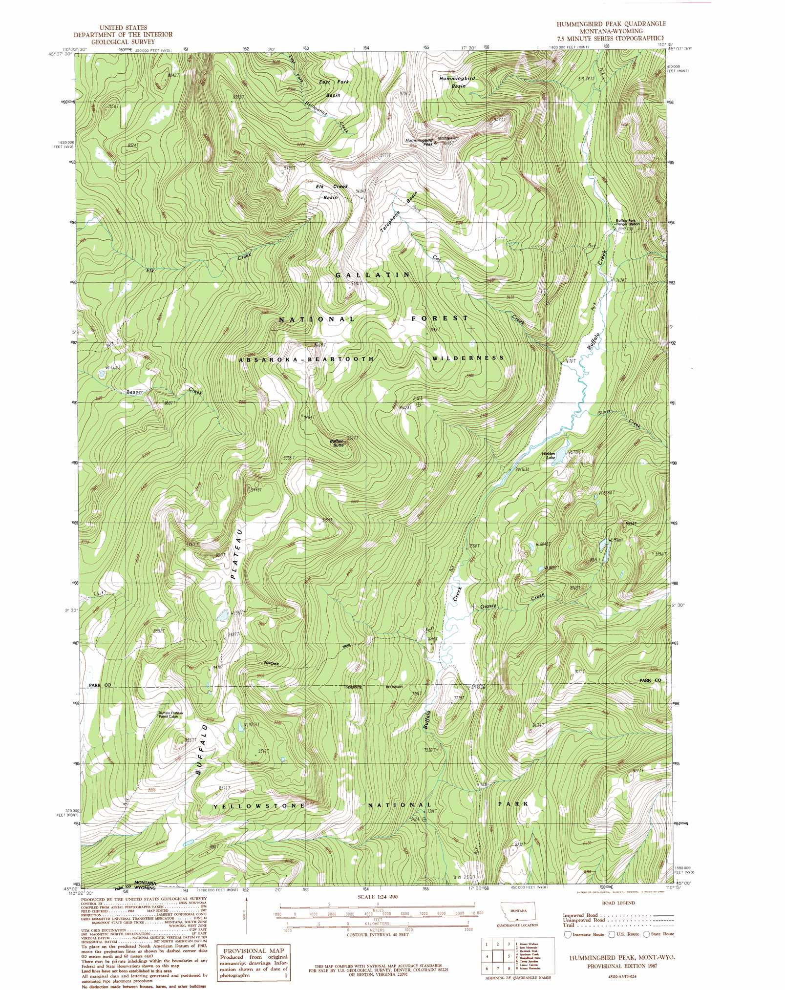
Hummingbird Peak Topo Map Montana
To zoom in, hover over the map of Hummingbird Peak
USGS Topo Quad 45110a3 - 1:24,000 scale
| Topo Map Name: | Hummingbird Peak |
| USGS Topo Quad ID: | 45110a3 |
| Print Size: | ca. 21 1/4" wide x 27" high |
| Southeast Coordinates: | 45° N latitude / 110.25° W longitude |
| Map Center Coordinates: | 45.0625° N latitude / 110.3125° W longitude |
| U.S. States: | MT, WY |
| Filename: | o45110a3.jpg |
| Download Map JPG Image: | Hummingbird Peak topo map 1:24,000 scale |
| Map Type: | Topographic |
| Topo Series: | 7.5´ |
| Map Scale: | 1:24,000 |
| Source of Map Images: | United States Geological Survey (USGS) |
| Alternate Map Versions: |
Hummingbird Peak MT 1987, updated 1987 Download PDF Buy paper map Hummingbird Peak MT 2000, updated 2005 Download PDF Buy paper map Hummingbird Peak MT 2011 Download PDF Buy paper map Hummingbird Peak MT 2014 Download PDF Buy paper map |
| FStopo: | US Forest Service topo Hummingbird Peak is available: Download FStopo PDF Download FStopo TIF |
1:24,000 Topo Quads surrounding Hummingbird Peak
Knowles Peak |
The Pyramid |
The Needles |
Mount Douglas |
Tumble Mountain |
Mineral Mountain |
Mount Wallace |
Iron Mountain |
Haystack Peak |
Pinnacle Mountain |
Ash Mountain |
Specimen Creek |
Hummingbird Peak |
Roundhead Butte |
Cutoff Mountain |
Blacktail Deer Creek |
Tower Junction |
Lamar Canyon |
Mount Hornaday |
Abiathar Peak |
Cook Peak |
Mount Washburn |
Amethyst Mountain |
Opal Creek |
Wahb Springs |
> Back to 45110a1 at 1:100,000 scale
> Back to 45110a1 at 1:250,000 scale
> Back to U.S. Topo Maps home
Hummingbird Peak topo map: Gazetteer
Hummingbird Peak: Basins
East Fork Basin elevation 2766m 9074′Elk Creek Basin elevation 2788m 9146′
Hummingbird Basin elevation 2785m 9137′
Telephone Basin elevation 2730m 8956′
Hummingbird Peak: Lakes
Hidden Lake elevation 2355m 7726′Hummingbird Peak: Streams
Cat Creek elevation 2337m 7667′Grassy Creek elevation 2300m 7545′
Silver Creek elevation 2339m 7673′
Hummingbird Peak: Summits
Buffalo Butte elevation 2861m 9386′Hummingbird Peak elevation 3051m 10009′
Hummingbird Peak: Trails
Poacher Trail elevation 2851m 9353′Hummingbird Peak digital topo map on disk
Buy this Hummingbird Peak topo map showing relief, roads, GPS coordinates and other geographical features, as a high-resolution digital map file on DVD: