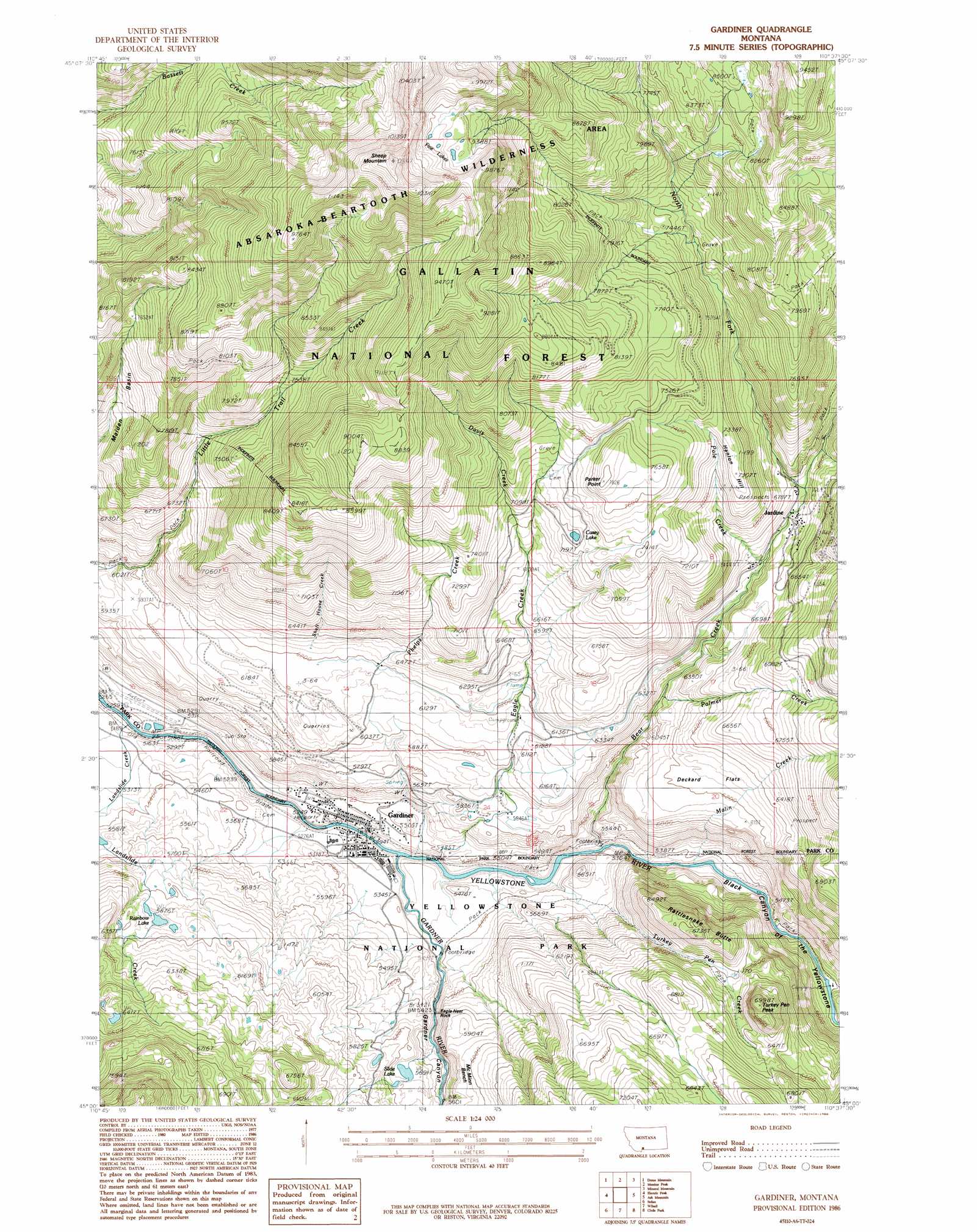
Gardiner Topo Map Montana
To zoom in, hover over the map of Gardiner
USGS Topo Quad 45110a6 - 1:24,000 scale
| Topo Map Name: | Gardiner |
| USGS Topo Quad ID: | 45110a6 |
| Print Size: | ca. 21 1/4" wide x 27" high |
| Southeast Coordinates: | 45° N latitude / 110.625° W longitude |
| Map Center Coordinates: | 45.0625° N latitude / 110.6875° W longitude |
| U.S. State: | MT |
| Filename: | o45110a6.jpg |
| Download Map JPG Image: | Gardiner topo map 1:24,000 scale |
| Map Type: | Topographic |
| Topo Series: | 7.5´ |
| Map Scale: | 1:24,000 |
| Source of Map Images: | United States Geological Survey (USGS) |
| Alternate Map Versions: |
Gardiner MT 1986, updated 1986 Download PDF Buy paper map Gardiner MT 2000, updated 2005 Download PDF Buy paper map Gardiner MT 2011 Download PDF Buy paper map Gardiner MT 2014 Download PDF Buy paper map |
| FStopo: | US Forest Service topo Gardiner is available: Download FStopo PDF Download FStopo TIF |
1:24,000 Topo Quads surrounding Gardiner
Lewis Creek |
Dailey Lake |
Emigrant |
Knowles Peak |
The Pyramid |
Miner |
Dome Mountain |
Monitor Peak |
Mineral Mountain |
Mount Wallace |
Sportsman Lake |
Electric Peak |
Gardiner |
Ash Mountain |
Specimen Creek |
Joseph Peak |
Quadrant Mountain |
Mammoth |
Blacktail Deer Creek |
Tower Junction |
Three Rivers Peak |
Mount Holmes |
Obsidian Cliff |
Cook Peak |
Mount Washburn |
> Back to 45110a1 at 1:100,000 scale
> Back to 45110a1 at 1:250,000 scale
> Back to U.S. Topo Maps home
Gardiner topo map: Gazetteer
Gardiner: Airports
Gardiner Airport elevation 1610m 5282′Gardiner: Basins
Maiden Basin elevation 2185m 7168′Gardiner: Benches
McMinn Bench elevation 1815m 5954′Gardiner: Bridges
Yellowstone River Bridge elevation 1592m 5223′Gardiner: Capes
Parker Point elevation 2369m 7772′Gardiner: Flats
Deckard Flats elevation 1911m 6269′Gardiner: Lakes
Casey Lake elevation 2193m 7194′Five Lakes elevation 2892m 9488′
Rainbow Lake elevation 1793m 5882′
Slide Lake elevation 1741m 5711′
Gardiner: Parks
Gardiner Community Park elevation 1614m 5295′Gardiner: Pillars
Eagle Nest Rock elevation 1676m 5498′Gardiner: Populated Places
Calamity Janes Trailer Court elevation 1603m 5259′Gardiner elevation 1603m 5259′
Jardine elevation 1967m 6453′
Rocky Mountain Trailer Park elevation 1603m 5259′
Gardiner: Post Offices
Gardiner Post Office elevation 1603m 5259′Jardine Post Office (historical) elevation 1967m 6453′
Gardiner: Streams
Bear Creek elevation 1619m 5311′Davis Creek elevation 2084m 6837′
Eagle Creek elevation 1600m 5249′
Gardner River elevation 1596m 5236′
Gardner River elevation 1604m 5262′
Landslide Creek elevation 1580m 5183′
Malin Creek elevation 1618m 5308′
North Fork Bear Creek elevation 1979m 6492′
Palmer Creek elevation 1818m 5964′
Phelps Creek elevation 1602m 5255′
Pine Creek elevation 2048m 6719′
Pole Creek elevation 1955m 6414′
Shaft House Creek elevation 1909m 6263′
Turkey Pen Creek elevation 1690m 5544′
Gardiner: Summits
Hanlon Hill elevation 2208m 7244′Rattlesnake Butte elevation 2049m 6722′
Sheep Mountain elevation 3189m 10462′
Turkey Pen Peak elevation 2129m 6984′
Gardiner: Trails
Rescue Creek Trail elevation 1903m 6243′Gardiner: Valleys
Black Canyon of the Yellowstone elevation 1614m 5295′Gardner Canyon elevation 1654m 5426′
Gardner Canyon elevation 1656m 5433′
Gardiner: Wells
09s08e23ddcb01 Well elevation 1623m 5324′Gardiner digital topo map on disk
Buy this Gardiner topo map showing relief, roads, GPS coordinates and other geographical features, as a high-resolution digital map file on DVD: