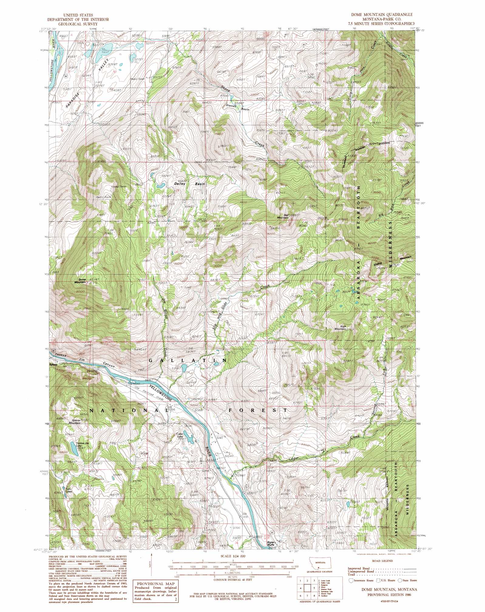
Dome Mountain Topo Map Montana
To zoom in, hover over the map of Dome Mountain
USGS Topo Quad 45110b7 - 1:24,000 scale
| Topo Map Name: | Dome Mountain |
| USGS Topo Quad ID: | 45110b7 |
| Print Size: | ca. 21 1/4" wide x 27" high |
| Southeast Coordinates: | 45.125° N latitude / 110.75° W longitude |
| Map Center Coordinates: | 45.1875° N latitude / 110.8125° W longitude |
| U.S. State: | MT |
| Filename: | o45110b7.jpg |
| Download Map JPG Image: | Dome Mountain topo map 1:24,000 scale |
| Map Type: | Topographic |
| Topo Series: | 7.5´ |
| Map Scale: | 1:24,000 |
| Source of Map Images: | United States Geological Survey (USGS) |
| Alternate Map Versions: |
Dome Mountain MT 1986, updated 1986 Download PDF Buy paper map Dome Mountain MT 2000, updated 2005 Download PDF Buy paper map Dome Mountain MT 2011 Download PDF Buy paper map Dome Mountain MT 2014 Download PDF Buy paper map |
| FStopo: | US Forest Service topo Dome Mountain is available: Download FStopo PDF Download FStopo TIF |
1:24,000 Topo Quads surrounding Dome Mountain
Mount Blackmore |
Fridley Peak |
Big Draw |
Pray |
Dexter Point |
The Sentinel |
Lewis Creek |
Dailey Lake |
Emigrant |
Knowles Peak |
Ramshorn Peak |
Miner |
Dome Mountain |
Monitor Peak |
Mineral Mountain |
Big Horn Peak |
Sportsman Lake |
Electric Peak |
Gardiner |
Ash Mountain |
Divide Lake |
Joseph Peak |
Quadrant Mountain |
Mammoth |
Blacktail Deer Creek |
> Back to 45110a1 at 1:100,000 scale
> Back to 45110a1 at 1:250,000 scale
> Back to U.S. Topo Maps home
Dome Mountain topo map: Gazetteer
Dome Mountain: Basins
Dailey Basin elevation 2020m 6627′Stands Basin elevation 2043m 6702′
Dome Mountain: Cliffs
Dick Randall Point elevation 2000m 6561′Rigler Bluffs elevation 1578m 5177′
Dome Mountain: Dams
Banana Peel Dam elevation 1654m 5426′Thelma Number 1 Dam elevation 1571m 5154′
Thelma Number 2 Dam elevation 1621m 5318′
Thelma Number 3 Dam elevation 1617m 5305′
Dome Mountain: Lakes
Cutler Lake elevation 1614m 5295′Twin Lakes elevation 1946m 6384′
Yankee Jim Lake elevation 2041m 6696′
Dome Mountain: Post Offices
Duderanch Post Office (historical) elevation 1766m 5793′Dome Mountain: Streams
Cedar Creek elevation 1545m 5068′Joe Brown Creek elevation 1537m 5042′
Little Pine Creek elevation 1758m 5767′
Mulherin Creek elevation 1546m 5072′
Second Fork Cedar Creek elevation 1853m 6079′
Sheep Creek elevation 1604m 5262′
Slip and Slide Creek elevation 1537m 5042′
Sphinx Creek elevation 1537m 5042′
Dome Mountain: Summits
Dome Mountain elevation 2613m 8572′High Mountain elevation 2661m 8730′
Red Mountain elevation 2693m 8835′
Sphinx Mountain elevation 2173m 7129′
Dome Mountain digital topo map on disk
Buy this Dome Mountain topo map showing relief, roads, GPS coordinates and other geographical features, as a high-resolution digital map file on DVD: