Miner Topo Map Montana
To zoom in, hover over the map of Miner
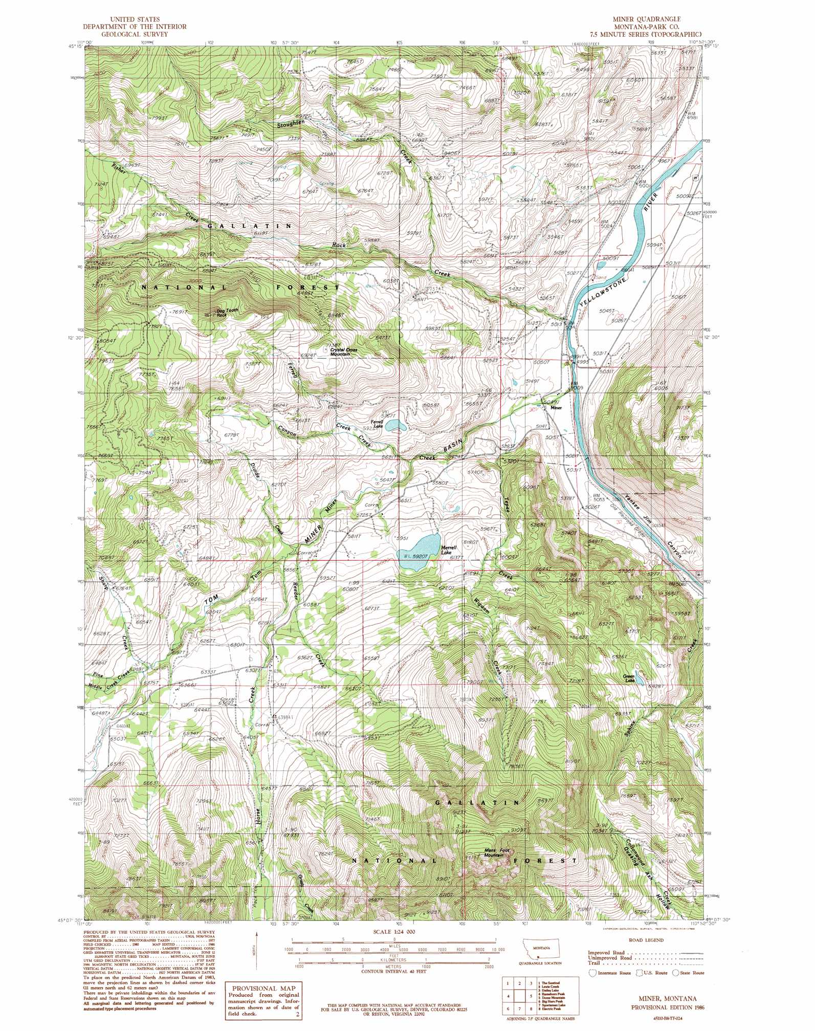
USGS Topo Quad 45110b8 - 1:24,000 scale
| Topo Map Name: | Miner |
| USGS Topo Quad ID: | 45110b8 |
| Print Size: | ca. 21 1/4" wide x 27" high |
| Southeast Coordinates: | 45.125° N latitude / 110.875° W longitude |
| Map Center Coordinates: | 45.1875° N latitude / 110.9375° W longitude |
| U.S. State: | MT |
| Filename: | o45110b8.jpg |
| Download Map JPG Image: | Miner topo map 1:24,000 scale |
| Map Type: | Topographic |
| Topo Series: | 7.5´ |
| Map Scale: | 1:24,000 |
| Source of Map Images: | United States Geological Survey (USGS) |
| Alternate Map Versions: |
Miner MT 1986, updated 1986 Download PDF Buy paper map Miner MT 2000, updated 2005 Download PDF Buy paper map Miner MT 2011 Download PDF Buy paper map Miner MT 2014 Download PDF Buy paper map |
| FStopo: | US Forest Service topo Miner is available: Download FStopo PDF Download FStopo TIF |
1:24,000 Topo Quads surrounding Miner
Garnet Mountain |
Mount Blackmore |
Fridley Peak |
Big Draw |
Pray |
Hidden Lake |
The Sentinel |
Lewis Creek |
Dailey Lake |
Emigrant |
Lone Indian Peak |
Ramshorn Peak |
Miner |
Dome Mountain |
Monitor Peak |
Sunshine Point |
Big Horn Peak |
Sportsman Lake |
Electric Peak |
Gardiner |
Upper Tepee Basin |
Divide Lake |
Joseph Peak |
Quadrant Mountain |
Mammoth |
> Back to 45110a1 at 1:100,000 scale
> Back to 45110a1 at 1:250,000 scale
> Back to U.S. Topo Maps home
Miner topo map: Gazetteer
Miner: Basins
Tom Miner Basin elevation 1760m 5774′Miner: Dams
Merrell Dam elevation 1806m 5925′Miner: Lakes
Ferrell Lake elevation 1759m 5770′Green Lake elevation 1952m 6404′
Merrell Lake elevation 1806m 5925′
Miner: Pillars
Dog Tooth Rock elevation 2359m 7739′Miner: Populated Places
Carbella elevation 1544m 5065′Miner elevation 1539m 5049′
Sphinx elevation 1567m 5141′
Miner: Post Offices
Carbella Post Office (historical) elevation 1544m 5065′Miner Post Office (historical) elevation 1539m 5049′
Miner: Streams
Canyon Creek elevation 1656m 5433′Divide Creek elevation 1766m 5793′
Ferrell Creek elevation 1799m 5902′
Fisher Creek elevation 1906m 6253′
Grizzly Creek elevation 2004m 6574′
Horse Creek elevation 1776m 5826′
Middle Creek elevation 1928m 6325′
Pine Creek elevation 1902m 6240′
Reeder Creek elevation 1766m 5793′
Rock Creek elevation 1523m 4996′
Sharp Creek elevation 1904m 6246′
Stoughten Creek elevation 1684m 5524′
Tepee Creek elevation 1554m 5098′
Tom Miner Creek elevation 1527m 5009′
Wigwam Creek elevation 1812m 5944′
Miner: Summits
Black Mountain elevation 2677m 8782′Crystal Cross Mountain elevation 2158m 7080′
Mans Foot Mountain elevation 2869m 9412′
Miner: Valleys
Quaking Ash Hollow elevation 1970m 6463′Yankee Jim Canyon elevation 1525m 5003′
Miner digital topo map on disk
Buy this Miner topo map showing relief, roads, GPS coordinates and other geographical features, as a high-resolution digital map file on DVD: