Lewis Creek Topo Map Montana
To zoom in, hover over the map of Lewis Creek
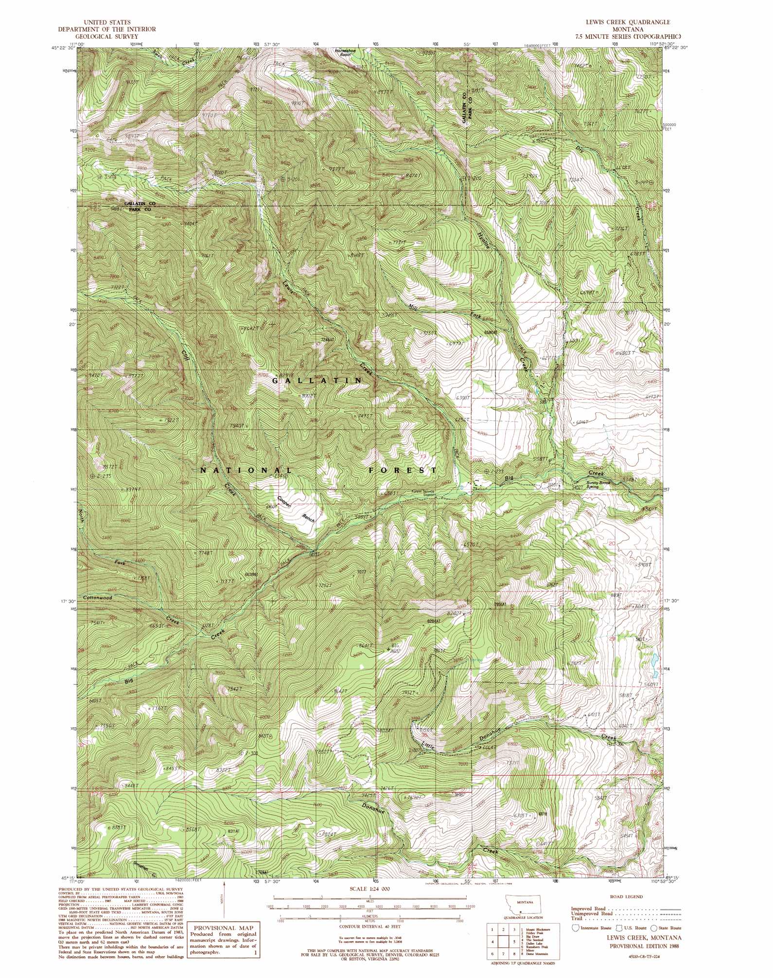
USGS Topo Quad 45110c8 - 1:24,000 scale
| Topo Map Name: | Lewis Creek |
| USGS Topo Quad ID: | 45110c8 |
| Print Size: | ca. 21 1/4" wide x 27" high |
| Southeast Coordinates: | 45.25° N latitude / 110.875° W longitude |
| Map Center Coordinates: | 45.3125° N latitude / 110.9375° W longitude |
| U.S. State: | MT |
| Filename: | o45110c8.jpg |
| Download Map JPG Image: | Lewis Creek topo map 1:24,000 scale |
| Map Type: | Topographic |
| Topo Series: | 7.5´ |
| Map Scale: | 1:24,000 |
| Source of Map Images: | United States Geological Survey (USGS) |
| Alternate Map Versions: |
Lewis Creek MT 1988, updated 1988 Download PDF Buy paper map Lewis Creek MT 1988, updated 1988 Download PDF Buy paper map Lewis Creek MT 2000, updated 2005 Download PDF Buy paper map Lewis Creek MT 2011 Download PDF Buy paper map Lewis Creek MT 2014 Download PDF Buy paper map |
| FStopo: | US Forest Service topo Lewis Creek is available: Download FStopo PDF Download FStopo TIF |
1:24,000 Topo Quads surrounding Lewis Creek
Gallatin Gateway |
Wheeler Mountain |
Mount Ellis |
Bald Knob |
Chimney Rock |
Garnet Mountain |
Mount Blackmore |
Fridley Peak |
Big Draw |
Pray |
Hidden Lake |
The Sentinel |
Lewis Creek |
Dailey Lake |
Emigrant |
Lone Indian Peak |
Ramshorn Peak |
Miner |
Dome Mountain |
Monitor Peak |
Sunshine Point |
Big Horn Peak |
Sportsman Lake |
Electric Peak |
Gardiner |
> Back to 45110a1 at 1:100,000 scale
> Back to 45110a1 at 1:250,000 scale
> Back to U.S. Topo Maps home
Lewis Creek topo map: Gazetteer
Lewis Creek: Benches
Cooper Bench elevation 1939m 6361′Lewis Creek: Populated Places
Kotke elevation 1935m 6348′Lewis Creek: Springs
Sunny Brook Spring elevation 1662m 5452′Lewis Creek: Streams
Cliff Creek elevation 1788m 5866′Cottonwood Creek elevation 1842m 6043′
Hyalite Creek elevation 1662m 5452′
Lewis Creek elevation 1726m 5662′
Mill Fork elevation 1878m 6161′
North Fork Cottonwood Creek elevation 1894m 6213′
Lewis Creek: Trails
Pole Gulch Trail elevation 2203m 7227′Red Rock Trail elevation 2267m 7437′
Lewis Creek digital topo map on disk
Buy this Lewis Creek topo map showing relief, roads, GPS coordinates and other geographical features, as a high-resolution digital map file on DVD: