Mcleod Topo Map Montana
To zoom in, hover over the map of Mcleod
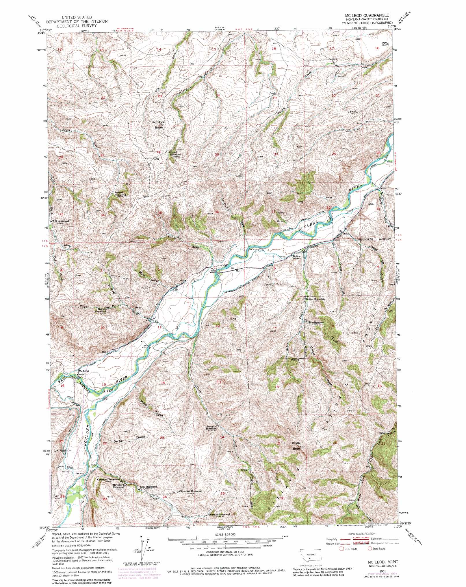
USGS Topo Quad 45110f1 - 1:24,000 scale
| Topo Map Name: | Mcleod |
| USGS Topo Quad ID: | 45110f1 |
| Print Size: | ca. 21 1/4" wide x 27" high |
| Southeast Coordinates: | 45.625° N latitude / 110° W longitude |
| Map Center Coordinates: | 45.6875° N latitude / 110.0625° W longitude |
| U.S. State: | MT |
| Filename: | o45110f1.jpg |
| Download Map JPG Image: | Mcleod topo map 1:24,000 scale |
| Map Type: | Topographic |
| Topo Series: | 7.5´ |
| Map Scale: | 1:24,000 |
| Source of Map Images: | United States Geological Survey (USGS) |
| Alternate Map Versions: |
Mc Leod MT 1951, updated 1953 Download PDF Buy paper map Mc Leod MT 1951, updated 1969 Download PDF Buy paper map Mc Leod MT 1951, updated 1981 Download PDF Buy paper map Mc Leod MT 2000, updated 2005 Download PDF Buy paper map McLeod MT 2011 Download PDF Buy paper map McLeod MT 2014 Download PDF Buy paper map |
| FStopo: | US Forest Service topo McLeod is available: Download FStopo PDF Download FStopo TIF |
1:24,000 Topo Quads surrounding Mcleod
Fairview Peak |
Raspberry Butte |
Grosfield Ranch |
Otter Creek School |
Ryan Creek |
Hunters Hot Springs |
Kelly Hills |
Carney |
Big Timber |
Greycliff |
Elton |
Springdale |
Mcleod |
Ross Canyon |
Packsaddle Butte |
Mount Rae |
Mcleod Basin |
Squaw Peak |
Sliderock Mountain |
Wildcat Draw |
West Boulder Plateau |
Chrome Mountain |
Picket Pin Mountain |
Meyer Mountain |
Nye |
> Back to 45110e1 at 1:100,000 scale
> Back to 45110a1 at 1:250,000 scale
> Back to U.S. Topo Maps home
Mcleod topo map: Gazetteer
Mcleod: Canals
Loasby Ditch elevation 1458m 4783′Mc Comb Campbell Ditch elevation 1400m 4593′
Michael Ditch elevation 1406m 4612′
Miles Flower Ditch elevation 1482m 4862′
Schmidelkoffer Dutton Vogers Ditch elevation 1421m 4662′
Smoot Ditch elevation 1382m 4534′
Mcleod: Populated Places
McLeod elevation 1464m 4803′Mcleod: Post Offices
McLeod Post Office elevation 1471m 4826′Mcleod: Springs
01S14E28BABB01 Spring elevation 1415m 4642′02S13E11BBBC01 Spring elevation 1506m 4940′
02S14E05CBCB01 Spring elevation 1419m 4655′
Mcleod: Streams
Bohee Creek elevation 1384m 4540′Castle Creek elevation 1427m 4681′
Cherry Creek elevation 1423m 4668′
Conant Creek elevation 1400m 4593′
Dore Creek elevation 1573m 5160′
Susie Creek elevation 1463m 4799′
West Boulder River elevation 1452m 4763′
Mcleod: Summits
Antelope Butte elevation 1570m 5150′Castle Butte elevation 1916m 6286′
Mcleod: Valleys
Barn Gulch elevation 1457m 4780′Corker Canyon elevation 1461m 4793′
Decker Gulch elevation 1482m 4862′
Edgar Gulch elevation 1501m 4924′
Fuller Draw elevation 1420m 4658′
Happy Jack Gulch elevation 1401m 4596′
McComb Draw elevation 1416m 4645′
Michael Gulch elevation 1459m 4786′
Miles Gulch elevation 1470m 4822′
Schoolhouse Gulch elevation 1458m 4783′
Mcleod: Wells
01S14E21DCCD01 Well elevation 1374m 4507′01S14E28ABBD01 Well elevation 1368m 4488′
01S14E32CADB01 Well elevation 1382m 4534′
02S13E01ACDB01 Well elevation 1411m 4629′
02S13E01BACA01 Well elevation 1444m 4737′
02S13E01BDDD01 Well elevation 1417m 4648′
02S13E01DBBC01 Well elevation 1412m 4632′
02S13E10DCDA01 Well elevation 1470m 4822′
02S13E11CDCC01 Well elevation 1440m 4724′
02S13E15AABB01 Well elevation 1463m 4799′
02S13E15BAAA01 Well elevation 1472m 4829′
02S13E15BBCD01 Well elevation 1469m 4819′
02S13E15BCBB01 Well elevation 1480m 4855′
02S13E15CAAC01 Well elevation 1462m 4796′
02S13E15CABB01 Well elevation 1464m 4803′
02S14E06AABB01 Well elevation 1394m 4573′
02S14E06AADA01 Well elevation 1400m 4593′
Mcleod digital topo map on disk
Buy this Mcleod topo map showing relief, roads, GPS coordinates and other geographical features, as a high-resolution digital map file on DVD: