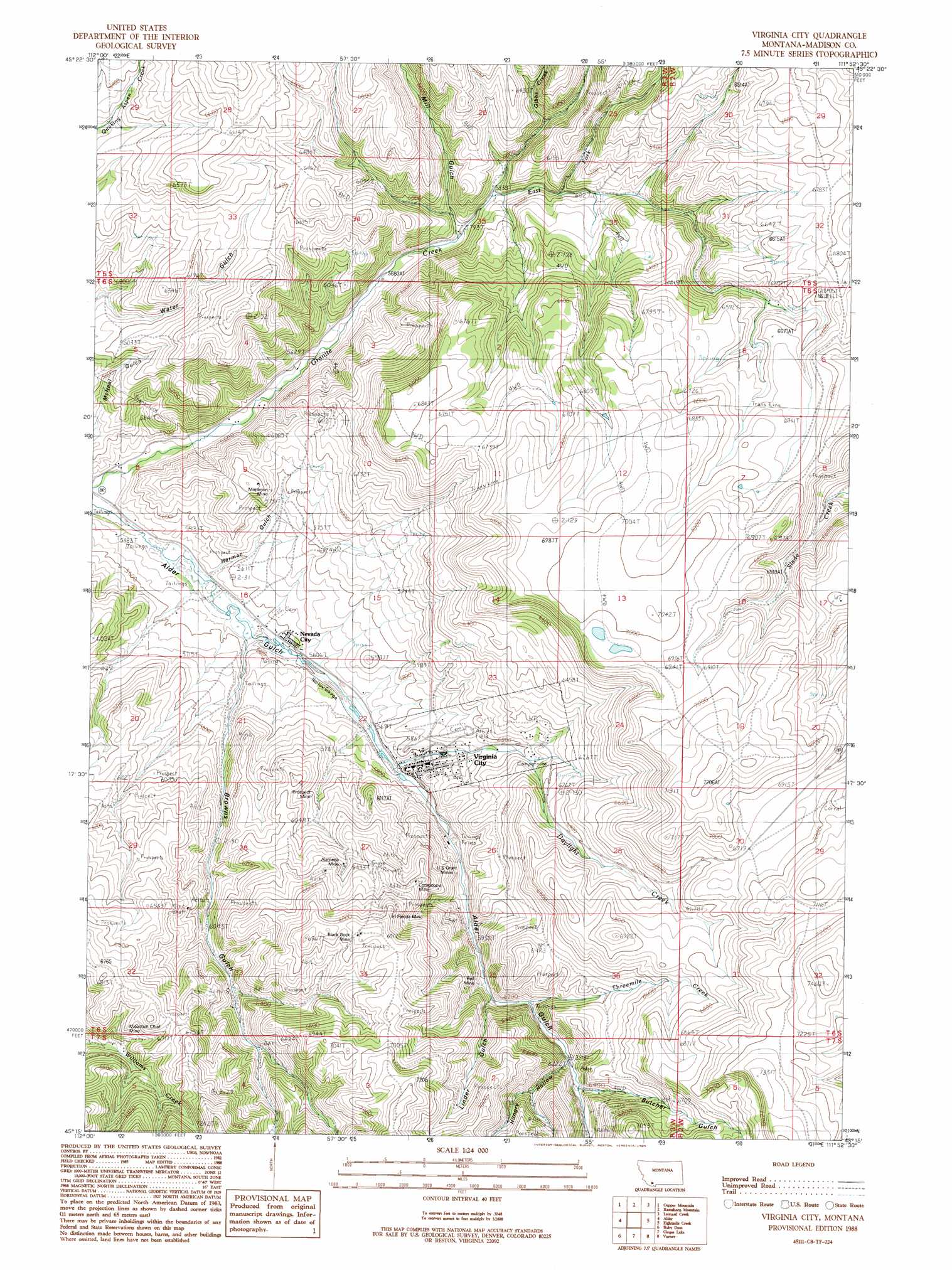
Virginia City Topo Map Montana
To zoom in, hover over the map of Virginia City
USGS Topo Quad 45111c8 - 1:24,000 scale
| Topo Map Name: | Virginia City |
| USGS Topo Quad ID: | 45111c8 |
| Print Size: | ca. 21 1/4" wide x 27" high |
| Southeast Coordinates: | 45.25° N latitude / 111.875° W longitude |
| Map Center Coordinates: | 45.3125° N latitude / 111.9375° W longitude |
| U.S. State: | MT |
| Filename: | o45111c8.jpg |
| Download Map JPG Image: | Virginia City topo map 1:24,000 scale |
| Map Type: | Topographic |
| Topo Series: | 7.5´ |
| Map Scale: | 1:24,000 |
| Source of Map Images: | United States Geological Survey (USGS) |
| Alternate Map Versions: |
Virginia City MT 1988, updated 1989 Download PDF Buy paper map Virginia City MT 2011 Download PDF Buy paper map Virginia City MT 2014 Download PDF Buy paper map |
1:24,000 Topo Quads surrounding Virginia City
Old Baldy Mountain |
Noble Peak |
Potosi Peak |
Maltbys Mound |
Norris |
Sheridan |
Copper Mountain |
Ramshorn Mountain |
Leonard Creek |
Ennis Lake |
Laurin Canyon |
Alder |
Virginia City |
Eightmile Creek |
Ennis |
Metzel Ranch |
Ruby Dam |
Cirque Lake |
Varney |
Cameron |
Belmont Park Ranch |
Home Park Ranch |
Warm Springs Creek |
Broomtail Ridge |
Bucks Nest |
> Back to 45111a1 at 1:100,000 scale
> Back to 45110a1 at 1:250,000 scale
> Back to U.S. Topo Maps home
Virginia City topo map: Gazetteer
Virginia City: Mines
Alameda Mine elevation 1927m 6322′Alameda Mine elevation 1941m 6368′
Bamboo Chief Mine elevation 2076m 6811′
Bell Mine elevation 1848m 6062′
Belle Mine elevation 1837m 6026′
Black Rock Mine elevation 2092m 6863′
Black Rock Mine elevation 2093m 6866′
Cabin Mine elevation 1873m 6145′
Cornucopia Mine elevation 1972m 6469′
Cornucopia Mine elevation 1971m 6466′
Don-A-Vera/Jayhill Mine elevation 1835m 6020′
East Mapleton Mine elevation 1768m 5800′
El Fleeda Mine elevation 2094m 6870′
El Fleeda Mine elevation 2079m 6820′
Highland Chief Mine elevation 2022m 6633′
Highland Mine elevation 1938m 6358′
Kakoosta Mine elevation 2088m 6850′
Lucky Strike Mine elevation 1906m 6253′
Mapleton Mine elevation 1800m 5905′
Miller Number 1 Mine elevation 2000m 6561′
Mountain Chief Mine elevation 2017m 6617′
Mountain Chief Mine elevation 1969m 6459′
Mountain Flower Mine elevation 1973m 6473′
NE Section 4 Mine elevation 1923m 6309′
New Gold Bar Mine elevation 2022m 6633′
NW Section 29 Mine elevation 1841m 6040′
Prospect Mine elevation 1829m 6000′
Prospect Mine elevation 1918m 6292′
SW Section 26 Mine elevation 1838m 6030′
SW Section 28 Mine elevation 1813m 5948′
SW Section 33 Mine elevation 2008m 6587′
Teresa Mine elevation 1960m 6430′
U S Grant-Upper Mine elevation 1832m 6010′
United States Grant Mines elevation 1870m 6135′
Wilson-Bell Mine elevation 1842m 6043′
Virginia City: Parks
Adobetown Historical Marker elevation 1684m 5524′Nevada City Historical Marker elevation 1699m 5574′
Virginia City Historical Marker elevation 1746m 5728′
Virginia City Park elevation 1801m 5908′
Virginia City: Populated Places
Central City (historical) elevation 1730m 5675′Junction elevation 1654m 5426′
Virginia City elevation 1756m 5761′
Virginia City: Post Offices
Adobetown Post Office (historical) elevation 1691m 5547′Junction Post Office (historical) elevation 1654m 5426′
Virginia City Post Office elevation 1761m 5777′
Virginia City: Streams
Daylight Creek elevation 1750m 5741′East Fork Granite Creek elevation 1779m 5836′
Gibbs Creek elevation 1829m 6000′
Threemile Creek elevation 1870m 6135′
West Fork Granite Creek elevation 1754m 5754′
Virginia City: Valleys
Browns Gulch elevation 1696m 5564′Butcher Gulch elevation 1908m 6259′
Herman Gulch elevation 1683m 5521′
Hungry Hollow elevation 1902m 6240′
Linder Gulch elevation 2046m 6712′
Mill Gulch elevation 1789m 5869′
Virginia City digital topo map on disk
Buy this Virginia City topo map showing relief, roads, GPS coordinates and other geographical features, as a high-resolution digital map file on DVD: