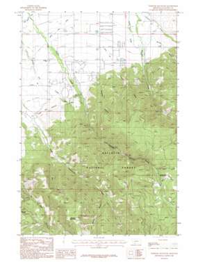
Wheeler Mountain Topo Map Montana
To zoom in, hover over the map of Wheeler Mountain
USGS Topo Quad 45111e1 - 1:24,000 scale
| Topo Map Name: | Wheeler Mountain |
| USGS Topo Quad ID: | 45111e1 |
| Print Size: | ca. 21 1/4" wide x 27" high |
| Southeast Coordinates: | 45.5° N latitude / 111° W longitude |
| Map Center Coordinates: | 45.5625° N latitude / 111.0625° W longitude |
| U.S. State: | MT |
| Filename: | o45111e1.jpg |
| Download Map JPG Image: | Wheeler Mountain topo map 1:24,000 scale |
| Map Type: | Topographic |
| Topo Series: | 7.5´ |
| Map Scale: | 1:24,000 |
| Source of Map Images: | United States Geological Survey (USGS) |
| Alternate Map Versions: |
Wheeler Mountain MT 1987, updated 1987 Download PDF Buy paper map Wheeler Mountain MT 1987, updated 1987 Download PDF Buy paper map Wheeler Mountain MT 2000, updated 2005 Download PDF Buy paper map Wheeler Mountain MT 2011 Download PDF Buy paper map Wheeler Mountain MT 2014 Download PDF Buy paper map |
| FStopo: | US Forest Service topo Wheeler Mountain is available: Download FStopo PDF Download FStopo TIF |
1:24,000 Topo Quads surrounding Wheeler Mountain
> Back to 45111e1 at 1:100,000 scale
> Back to 45110a1 at 1:250,000 scale
> Back to U.S. Topo Maps home
Wheeler Mountain topo map: Gazetteer
Wheeler Mountain: Canals
Middle Creek Association Ditch elevation 1683m 5521′Middle Creek Ditch elevation 1570m 5150′
Mystic Lake Ditch elevation 1607m 5272′
West Gallatin Canal elevation 1547m 5075′
Wheeler Mountain: Mines
Sunshine Mine elevation 2154m 7066′Wheeler Mountain: Springs
03S05E04CD__01 Spring elevation 1586m 5203′03S05E11DA__01 Spring elevation 1652m 5419′
03S05E11DDB_01 Spring elevation 1705m 5593′
03S05E11DDC_01 Spring elevation 1701m 5580′
03S05E12CB__01 Spring elevation 1677m 5501′
03S05E15CA__01 Spring elevation 1671m 5482′
03S05E21BD__02 Spring elevation 1661m 5449′
03S06E06BA__01 Spring elevation 1570m 5150′
Langohr Springs elevation 1907m 6256′
Wheeler Mountain: Streams
Buckskin Creek elevation 1873m 6145′Leverich Creek elevation 1609m 5278′
Moser Creek elevation 1863m 6112′
Nichols Creek elevation 1586m 5203′
Wheeler Mountain: Summits
Wheeler Mountain elevation 2621m 8599′Wheeler Mountain: Valleys
Dry Gulch elevation 1755m 5757′Hodgman Canyon elevation 1671m 5482′
Hyalite Canyon elevation 1646m 5400′
Wheeler Gulch elevation 1869m 6131′
Wheeler Mountain: Wells
02S05E33CB__01 Well elevation 1554m 5098′02S05E33DB__01 Well elevation 1561m 5121′
02S05E33DB__02 Well elevation 1561m 5121′
02S05E34CD__01 Well elevation 1577m 5173′
02S05E35CB__01 Well elevation 1574m 5164′
02S05E35DCDC01 Well elevation 1582m 5190′
02S05E35DD__01 Well elevation 1580m 5183′
02S05E35DD__02 Well elevation 1580m 5183′
02S05E36BACD01 Well elevation 1558m 5111′
02S05E36BADD01 Well elevation 1555m 5101′
02S05E36DD__01 Well elevation 1567m 5141′
02S06E31AD__01 Well elevation 1564m 5131′
02S06E31DB__01 Well elevation 1562m 5124′
02S06E32CB__02 Well elevation 1578m 5177′
03S05E01AC__01 Well elevation 1585m 5200′
03S05E01BA__01 Well elevation 1582m 5190′
03S05E01DC__01 Well elevation 1598m 5242′
03S05E02AD__01 Well elevation 1595m 5232′
03S05E02CD__01 Well elevation 1615m 5298′
03S05E02DA__01 Well elevation 1603m 5259′
03S05E03AB__01 Well elevation 1589m 5213′
03S05E03BB__01 Well elevation 1582m 5190′
03S05E03DA__01 Well elevation 1606m 5269′
03S05E04AAAD01 Well elevation 1578m 5177′
03S05E04AB__01 Well elevation 1573m 5160′
03S05E04BA__01 Well elevation 1569m 5147′
03S05E09AA__01 Well elevation 1603m 5259′
03S05E09DA__01 Well elevation 1613m 5291′
03S05E10BA__01 Well elevation 1611m 5285′
03S05E10BB__01 Well elevation 1610m 5282′
03S05E10CCCB01 Well elevation 1619m 5311′
03S05E10DB__01 Well elevation 1629m 5344′
03S05E11BC__01 Well elevation 1631m 5351′
03S05E11DAAC01 Well elevation 1649m 5410′
03S05E11DABD01 Well elevation 1647m 5403′
03S05E15DCCA01 Well elevation 1765m 5790′
03S05E16AA__01 Well elevation 1621m 5318′
03S05E21AB__01 Well elevation 1689m 5541′
03S05E21BBA_01 Well elevation 1651m 5416′
03S05E21BBBA01 Well elevation 1643m 5390′
03S05E21BBD_01 Well elevation 1651m 5416′
03S05E21BD__01 Well elevation 1661m 5449′
03S06E05BB__01 Well elevation 1600m 5249′
03S06E05CBAA01 Well elevation 1604m 5262′
03S06E06AC__01 Well elevation 1577m 5173′
03S06E06DA__01 Well elevation 1590m 5216′
03S06E06DD__01 Well elevation 1596m 5236′
03S06E06DD__02 Well elevation 1596m 5236′
Wheeler Mountain digital topo map on disk
Buy this Wheeler Mountain topo map showing relief, roads, GPS coordinates and other geographical features, as a high-resolution digital map file on DVD:


