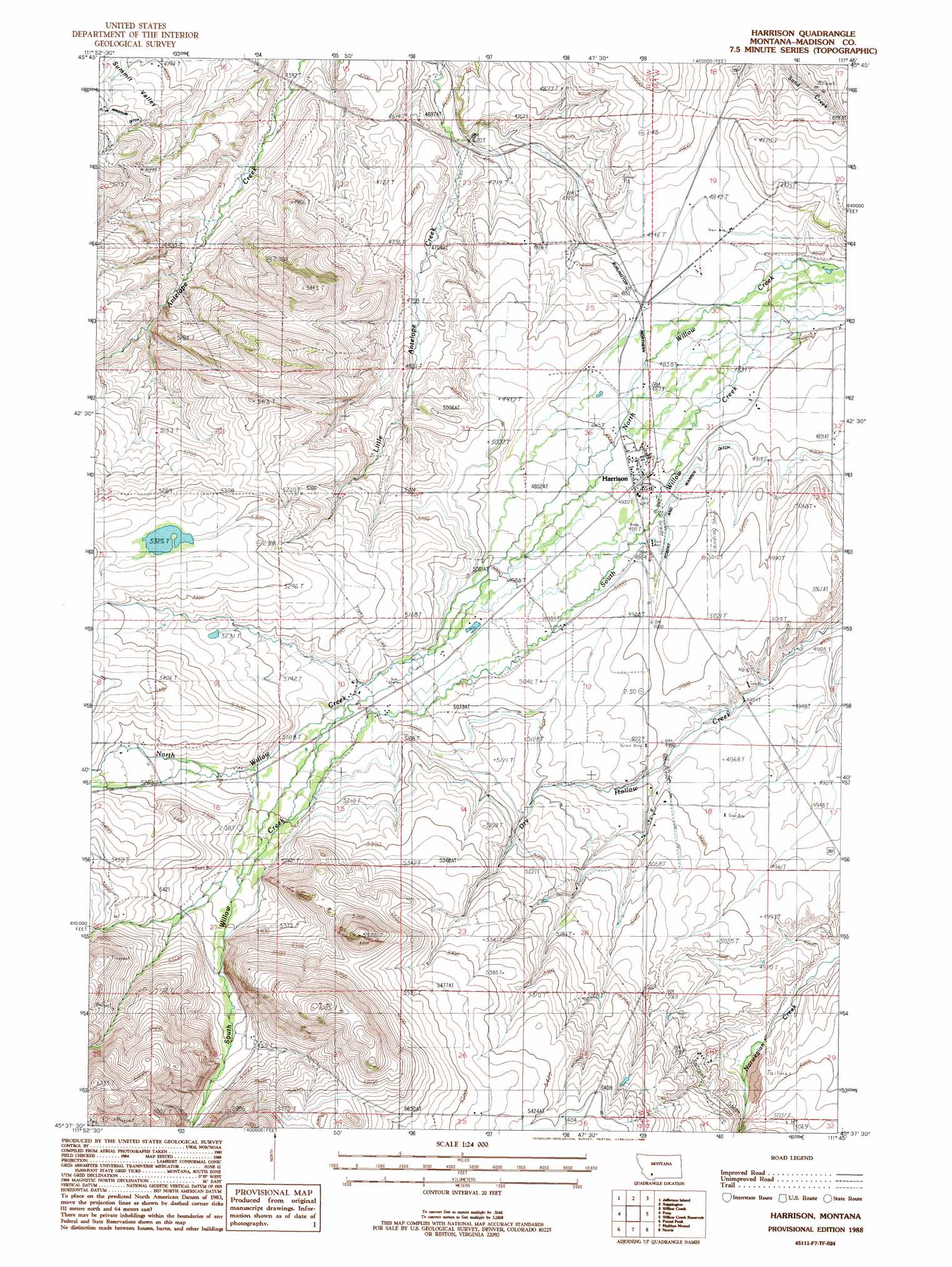
Harrison Topo Map Montana
To zoom in, hover over the map of Harrison
USGS Topo Quad 45111f7 - 1:24,000 scale
| Topo Map Name: | Harrison |
| USGS Topo Quad ID: | 45111f7 |
| Print Size: | ca. 21 1/4" wide x 27" high |
| Southeast Coordinates: | 45.625° N latitude / 111.75° W longitude |
| Map Center Coordinates: | 45.6875° N latitude / 111.8125° W longitude |
| U.S. State: | MT |
| Filename: | o45111f7.jpg |
| Download Map JPG Image: | Harrison topo map 1:24,000 scale |
| Map Type: | Topographic |
| Topo Series: | 7.5´ |
| Map Scale: | 1:24,000 |
| Source of Map Images: | United States Geological Survey (USGS) |
| Alternate Map Versions: |
Harrison MT 1988, updated 1988 Download PDF Buy paper map Harrison MT 2011 Download PDF Buy paper map Harrison MT 2014 Download PDF Buy paper map |
1:24,000 Topo Quads surrounding Harrison
Black Butte |
Doherty Mountain |
Negro Hollow |
Milligan Canyon |
Three Forks |
Whitehall |
Jefferson Island |
Sappington |
Willow Creek |
Three Forks Se |
Manhead Mountain |
Pony |
Harrison |
Willow Creek Reservoir |
Norris Ne |
Noble Peak |
Potosi Peak |
Maltbys Mound |
Norris |
Bear Trap Creek |
Copper Mountain |
Ramshorn Mountain |
Leonard Creek |
Ennis Lake |
Cherry Lake |
> Back to 45111e1 at 1:100,000 scale
> Back to 45110a1 at 1:250,000 scale
> Back to U.S. Topo Maps home
Harrison topo map: Gazetteer
Harrison: Canals
Gobble Ditch elevation 1495m 4904′Roebert and Warren Ditch elevation 1497m 4911′
Harrison: Dams
Dry Lake Dam elevation 1605m 5265′Harrison: Mines
Sand Creek Shafts elevation 1503m 4931′Harrison: Populated Places
Beals elevation 1407m 4616′Harrison elevation 1499m 4917′
Harrison Mill elevation 1463m 4799′
Shaws elevation 1528m 5013′
Stringtown (historical) elevation 1452m 4763′
Harrison: Post Offices
Harrison Post Office elevation 1498m 4914′Harrison Post Office (historical) elevation 1499m 4917′
Harrison: Streams
Beckwith Creek elevation 1576m 5170′Boyer Creek elevation 1609m 5278′
Harrison: Valleys
Norwegian Placer Gulch elevation 1515m 4970′Harrison: Wells
02S02W01AAAA01 Well elevation 1500m 4921′02S02W11BDBB01 Well elevation 1540m 5052′
02S02W13ADBA01 Well elevation 1533m 5029′
Harrison digital topo map on disk
Buy this Harrison topo map showing relief, roads, GPS coordinates and other geographical features, as a high-resolution digital map file on DVD: