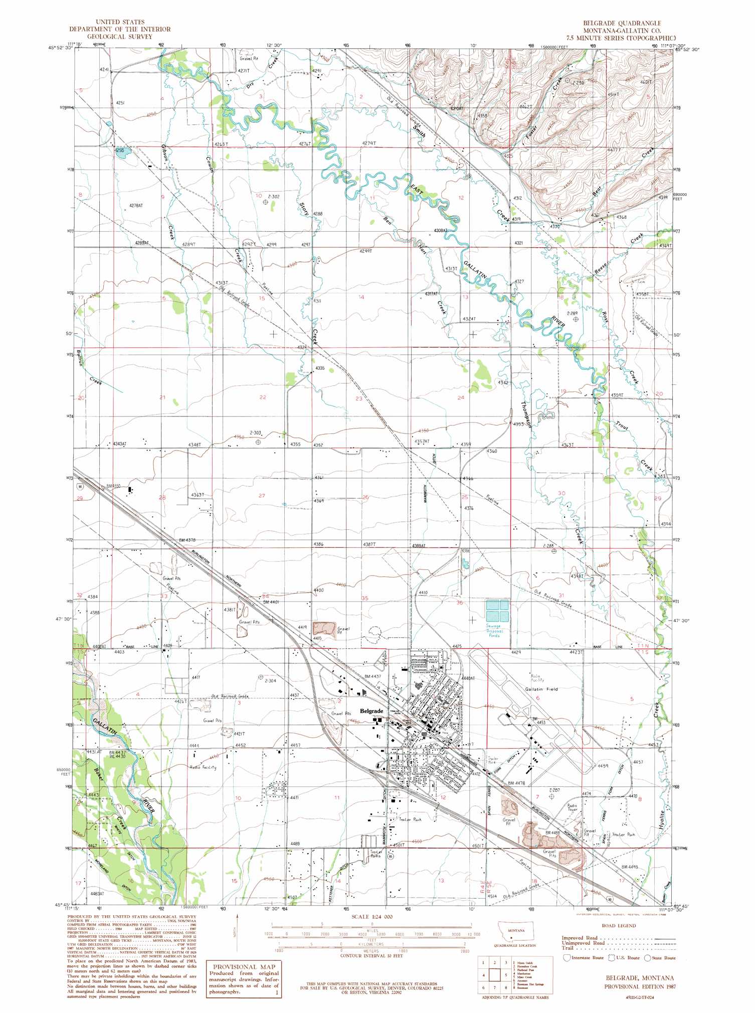
Belgrade Topo Map Montana
To zoom in, hover over the map of Belgrade
USGS Topo Quad 45111g2 - 1:24,000 scale
| Topo Map Name: | Belgrade |
| USGS Topo Quad ID: | 45111g2 |
| Print Size: | ca. 21 1/4" wide x 27" high |
| Southeast Coordinates: | 45.75° N latitude / 111.125° W longitude |
| Map Center Coordinates: | 45.8125° N latitude / 111.1875° W longitude |
| U.S. State: | MT |
| Filename: | o45111g2.jpg |
| Download Map JPG Image: | Belgrade topo map 1:24,000 scale |
| Map Type: | Topographic |
| Topo Series: | 7.5´ |
| Map Scale: | 1:24,000 |
| Source of Map Images: | United States Geological Survey (USGS) |
| Alternate Map Versions: |
Belgrade MT 1987, updated 1988 Download PDF Buy paper map Belgrade MT 2011 Download PDF Buy paper map Belgrade MT 2014 Download PDF Buy paper map |
1:24,000 Topo Quads surrounding Belgrade
Lombard |
Roy Gulch |
Maudlow |
Blacktail Mountain |
Hatfield Mountain |
Logan |
Nixon Gulch |
Horseshoe Creek |
Flathead Pass |
Sacagawea Peak |
Manhattan Sw |
Manhattan |
Belgrade |
Miser Creek |
Saddle Peak |
Madison Plateau |
Anceney |
Bozeman Hot Springs |
Bozeman |
Kelly Creek |
Cherry Creek Canyon |
Ruby Mountain |
Gallatin Gateway |
Wheeler Mountain |
Mount Ellis |
> Back to 45111e1 at 1:100,000 scale
> Back to 45110a1 at 1:250,000 scale
> Back to U.S. Topo Maps home
Belgrade topo map: Gazetteer
Belgrade: Airports
Gallatin Field Airport elevation 1358m 4455′Belgrade: Bridges
Irwin Bridge elevation 1351m 4432′Nelson Bridge elevation 1296m 4251′
Penwell Bridge elevation 1338m 4389′
Belgrade: Canals
Durham Ditch elevation 1361m 4465′J S Hoffman Ditch elevation 1363m 4471′
Moreland Ditch elevation 1363m 4471′
Spain Ferris Fork Ditch elevation 1363m 4471′
Weaver Ditch elevation 1370m 4494′
Belgrade: Channels
Gallatin Overflow Channel elevation 1350m 4429′Belgrade: Crossings
Interchange 298 elevation 1366m 4481′Belgrade: Parks
Childrens Park elevation 1356m 4448′Clarkin Park elevation 1361m 4465′
Lewis and Clark Park elevation 1360m 4461′
Lions Park elevation 1353m 4438′
Memorial Park elevation 1364m 4475′
Mountain View Park elevation 1367m 4484′
Prescott Park elevation 1348m 4422′
Quinella Park elevation 1359m 4458′
Sunnyside Park elevation 1366m 4481′
Triangle Park elevation 1361m 4465′
Belgrade: Populated Places
Belgrade elevation 1359m 4458′Belgrade Trailer Court elevation 1357m 4452′
Belgrade Village Mobile Home Park elevation 1361m 4465′
Faith Mobile Home Court elevation 1366m 4481′
Friendly Trailer Court elevation 1369m 4491′
Lexley Acres Mobile Home Park elevation 1369m 4491′
Potts Trailer Court elevation 1359m 4458′
Powers elevation 1343m 4406′
Star Mobile Home Park elevation 1359m 4458′
Voegeles Trailer Court elevation 1359m 4458′
Belgrade: Post Offices
Belgrade Post Office elevation 1357m 4452′Cedarview Post Office (historical) elevation 1299m 4261′
Dry Creek Post Office (historical) elevation 1302m 4271′
Belgrade: Streams
Aajker Creek elevation 1367m 4484′Baxter Creek elevation 1367m 4484′
Bear Creek elevation 1321m 4333′
Ben Hart Creek elevation 1308m 4291′
Cowan Creek elevation 1295m 4248′
Dry Creek elevation 1300m 4265′
Foster Creek elevation 1314m 4311′
Gibson Creek elevation 1293m 4242′
Hyalite Creek elevation 1345m 4412′
Reese Creek elevation 1321m 4333′
Ross Creek elevation 1320m 4330′
Smith Creek elevation 1303m 4274′
South Fork Ross Creek elevation 1333m 4373′
Story Creek elevation 1299m 4261′
Thompson Creek elevation 1318m 4324′
Trout Creek elevation 1328m 4356′
Belgrade: Wells
01N04E01CB__01 Well elevation 1311m 4301′01N04E01DBAB01 Well elevation 1337m 4386′
01N04E02AD__01 Well elevation 1314m 4311′
01N04E03AB__01 Well elevation 1308m 4291′
01N04E03AC__01 Well elevation 1305m 4281′
01N04E03BBAA01 Well elevation 1298m 4258′
01N04E03BC__01 Well elevation 1297m 4255′
01N04E04AC__01 Well elevation 1295m 4248′
01N04E05AD__01 Well elevation 1294m 4245′
01N04E05DA__01 Well elevation 1296m 4251′
01N04E05DD__01 Well elevation 1296m 4251′
01N04E05DDDD01 Well elevation 1298m 4258′
01N04E08AD__01 Well elevation 1302m 4271′
01N04E09AB__01 Well elevation 1301m 4268′
01N04E10AA__01 Well elevation 1303m 4274′
01N04E10AADD01 Well elevation 1305m 4281′
01N04E12CDCC01 Well elevation 1315m 4314′
01N04E13AD__01 Well elevation 1317m 4320′
01N04E14BBB_01 Well elevation 1311m 4301′
01N04E14BBC_01 Well elevation 1312m 4304′
01N04E14CC__01 Well elevation 1318m 4324′
01N04E15BA__01 Well elevation 1312m 4304′
01N04E15DA__01 Well elevation 1316m 4317′
01N04E15DADD01 Well elevation 1316m 4317′
01N04E16BB__01 Well elevation 1309m 4294′
01N04E21DC__01 Well elevation 1325m 4347′
01N04E22CC__01 Well elevation 1327m 4353′
01N04E22DC__01 Well elevation 1327m 4353′
01N04E22DC__02 Well elevation 1327m 4353′
01N04E22DC__03 Well elevation 1327m 4353′
01N04E22DC__04 Well elevation 1327m 4353′
01N04E22DD__01 Well elevation 1327m 4353′
01N04E23BB__01 Well elevation 1321m 4333′
01N04E23BB__02 Well elevation 1321m 4333′
01N04E24CD__01 Well elevation 1328m 4356′
01N04E24DC__01 Well elevation 1328m 4356′
01N04E25BD__01 Well elevation 1332m 4370′
01N04E25DC__01 Well elevation 1337m 4386′
01N04E25DCDD01 Well elevation 1338m 4389′
01N04E26CCCC01 Well elevation 1338m 4389′
01N04E28ABBB01 Well elevation 1327m 4353′
01N04E28ABBD01 Well elevation 1327m 4353′
01N04E28DA__01 Well elevation 1333m 4373′
01N04E28DA__02 Well elevation 1333m 4373′
01N04E28DA__03 Well elevation 1333m 4373′
01N04E33AA__01 Well elevation 1337m 4386′
01N04E33CC__01 Well elevation 1342m 4402′
01N04E33CD__01 Well elevation 1343m 4406′
01N04E33CDCC01 Well elevation 1344m 4409′
01N04E36DC__01 Well elevation 1349m 4425′
01N05E06BD__01 Well elevation 1349m 4425′
01N05E06CC__01 Well elevation 1330m 4363′
01N05E19BC__01 Well elevation 1325m 4347′
01N05E20CB__01 Well elevation 1331m 4366′
01N05E20DB__01 Well elevation 1333m 4373′
01N05E29AB__01 Well elevation 1336m 4383′
01N05E29CA__01 Well elevation 1337m 4386′
01N05E29CA__02 Well elevation 1337m 4386′
01N05E29CC__01 Well elevation 1340m 4396′
01N05E29DB__01 Well elevation 1339m 4393′
01N05E30CC__01 Well elevation 1337m 4386′
01N05E30CC__02 Well elevation 1337m 4386′
01N05E30DC__01 Well elevation 1337m 4386′
01N05E30DDAA01 Well elevation 1339m 4393′
01N05E32CCA_01 Well elevation 1348m 4422′
01N05E32CCD_01 Well elevation 1349m 4425′
01N05E32CCD_02 Well elevation 1349m 4425′
01S04E01ACCA01 Well elevation 1355m 4445′
01S04E01BC__01 Well elevation 1354m 4442′
01S04E01CB__01 Well elevation 1355m 4445′
01S04E01CDCB01 Well elevation 1359m 4458′
01S04E01DC__01 Well elevation 1360m 4461′
01S04E01DCBD01 Well elevation 1360m 4461′
01S04E01DDCC01 Well elevation 1362m 4468′
01S04E02AB__01 Well elevation 1351m 4432′
01S04E02BB__01 Well elevation 1350m 4429′
01S04E02DD__01 Well elevation 1359m 4458′
01S04E04AA__01 Well elevation 1346m 4416′
01S04E04CC__01 Well elevation 1348m 4422′
01S04E04CC__02 Well elevation 1348m 4422′
01S04E09AB__01 Well elevation 1355m 4445′
01S04E09BA__02 Well elevation 1352m 4435′
01S04E09BAAA01 Well elevation 1352m 4435′
01S04E09BC__01 Well elevation 1354m 4442′
01S04E09CB__01 Well elevation 1356m 4448′
01S04E10BA__01 Well elevation 1358m 4455′
01S04E10DB__01 Well elevation 1365m 4478′
01S04E10DD__01 Well elevation 1368m 4488′
01S04E10DDDD01 Well elevation 1369m 4491′
01S04E11BB__01 Well elevation 1361m 4465′
01S04E12BB__01 Well elevation 1362m 4468′
01S04E12CAAB01 Well elevation 1367m 4484′
01S04E12CB__01 Well elevation 1369m 4491′
01S04E12DA__01 Well elevation 1370m 4494′
01S04E13AD__01 Well elevation 1376m 4514′
01S04E13BB__01 Well elevation 1374m 4507′
01S04E14AA__01 Well elevation 1373m 4504′
01S04E14BB__01 Well elevation 1371m 4498′
01S04E15AB__01 Well elevation 1370m 4494′
01S04E15AD__01 Well elevation 1373m 4504′
01S04E16BB__01 Well elevation 1361m 4465′
01S05E05AD__01 Well elevation 1353m 4438′
01S05E05CCBB01 Well elevation 1358m 4455′
01S05E05CD__01 Well elevation 1358m 4455′
01S05E06CD__01 Well elevation 1360m 4461′
01S05E06DC__01 Well elevation 1359m 4458′
01S05E08AB__01 Well elevation 1359m 4458′
01S05E17AC__01 Well elevation 1368m 4488′
01S05E17BA__01 Well elevation 1369m 4491′
01S05E18BB__01 Well elevation 1374m 4507′
Belgrade digital topo map on disk
Buy this Belgrade topo map showing relief, roads, GPS coordinates and other geographical features, as a high-resolution digital map file on DVD: