Ashbough Canyon Topo Map Montana
To zoom in, hover over the map of Ashbough Canyon
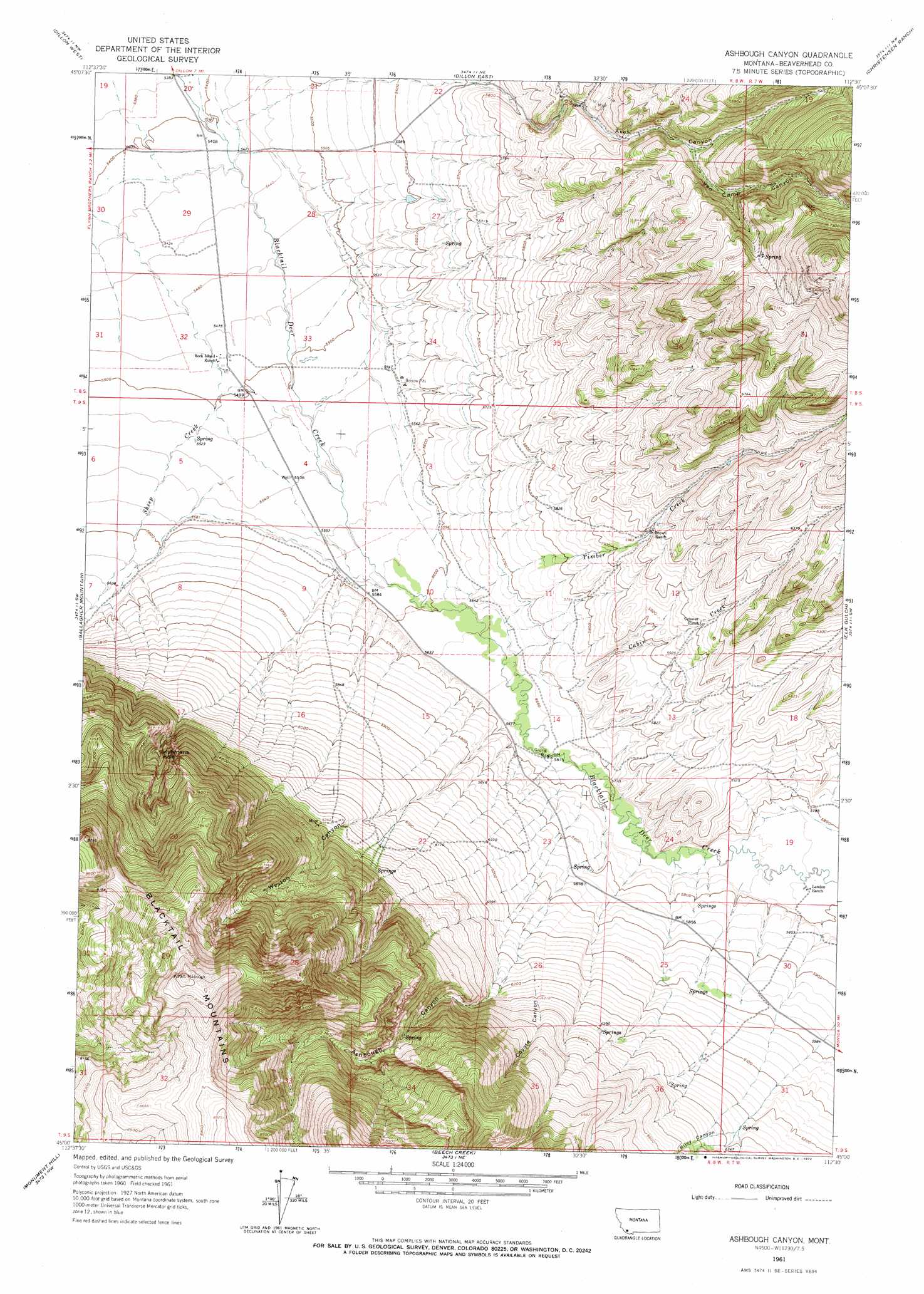
USGS Topo Quad 45112a5 - 1:24,000 scale
| Topo Map Name: | Ashbough Canyon |
| USGS Topo Quad ID: | 45112a5 |
| Print Size: | ca. 21 1/4" wide x 27" high |
| Southeast Coordinates: | 45° N latitude / 112.5° W longitude |
| Map Center Coordinates: | 45.0625° N latitude / 112.5625° W longitude |
| U.S. State: | MT |
| Filename: | o45112a5.jpg |
| Download Map JPG Image: | Ashbough Canyon topo map 1:24,000 scale |
| Map Type: | Topographic |
| Topo Series: | 7.5´ |
| Map Scale: | 1:24,000 |
| Source of Map Images: | United States Geological Survey (USGS) |
| Alternate Map Versions: |
Ashbough Canyon MT 1961, updated 1965 Download PDF Buy paper map Ashbough Canyon MT 1961, updated 1972 Download PDF Buy paper map Ashbough Canyon MT 2011 Download PDF Buy paper map Ashbough Canyon MT 2014 Download PDF Buy paper map |
1:24,000 Topo Quads surrounding Ashbough Canyon
Argenta |
Bond |
Glen Se |
Beaverhead Rock Sw |
Beaverhead Rock Se |
Burns Mountain |
Dillon West |
Dillon East |
Christensen Ranch |
Mine Gulch |
Dalys |
Gallagher Mountain |
Ashbough Canyon |
Elk Gulch |
Red Canyon |
Red Rock |
Monument Hill |
Beech Creek |
Price Creek |
Price Creek Ne |
Kidd |
Briggs Ranch |
Rock Island Ranch |
Vinegar Hill |
Whiskey Spring |
> Back to 45112a1 at 1:100,000 scale
> Back to 45112a1 at 1:250,000 scale
> Back to U.S. Topo Maps home
Ashbough Canyon topo map: Gazetteer
Ashbough Canyon: Basins
Irishmans Hole elevation 1974m 6476′Ashbough Canyon: Mines
Axes Canyon Mine elevation 1781m 5843′Ground Hog Mine elevation 2285m 7496′
NE NE Section 26 Mine elevation 1840m 6036′
Nevada Mine elevation 1955m 6414′
Smith Dillon Mine elevation 1872m 6141′
Ashbough Canyon: Springs
Blacktail Spring elevation 1826m 5990′Ashbough Canyon: Streams
Cabin Creek elevation 1719m 5639′Timber Creek elevation 1714m 5623′
Ashbough Canyon: Valleys
Ashbough Canyon elevation 1768m 5800′Axes Canyon elevation 1737m 5698′
Coyote Canyon elevation 1768m 5800′
Riley Canyon elevation 1830m 6003′
Van Camp Canyon elevation 1902m 6240′
Weston Canyon elevation 1732m 5682′
Ashbough Canyon: Wells
08S08W20ACCA02 Well elevation 1643m 5390′08S08W20DDCC01 Well elevation 1651m 5416′
08S08W28CBDA01 Well elevation 1664m 5459′
08S08W29CDAD01 Well elevation 1660m 5446′
08S08W30AAAA01 Well elevation 1647m 5403′
08S08W32CCAB01 Well elevation 1674m 5492′
08S08W32DACA01 Well elevation 1673m 5488′
08S08W32DACA02 Well elevation 1673m 5488′
08S08W32DBBA01 Well elevation 1671m 5482′
08S08W33CDBB01 Well elevation 1678m 5505′
09S08W04CAAC01 Well elevation 1689m 5541′
09S08W10BCDC01 Well elevation 1725m 5659′
09S08W14CDAD01 Well elevation 1728m 5669′
09S08W14CDAD02 Well elevation 1728m 5669′
Ashbough Canyon digital topo map on disk
Buy this Ashbough Canyon topo map showing relief, roads, GPS coordinates and other geographical features, as a high-resolution digital map file on DVD: