Gallagher Mountain Topo Map Montana
To zoom in, hover over the map of Gallagher Mountain
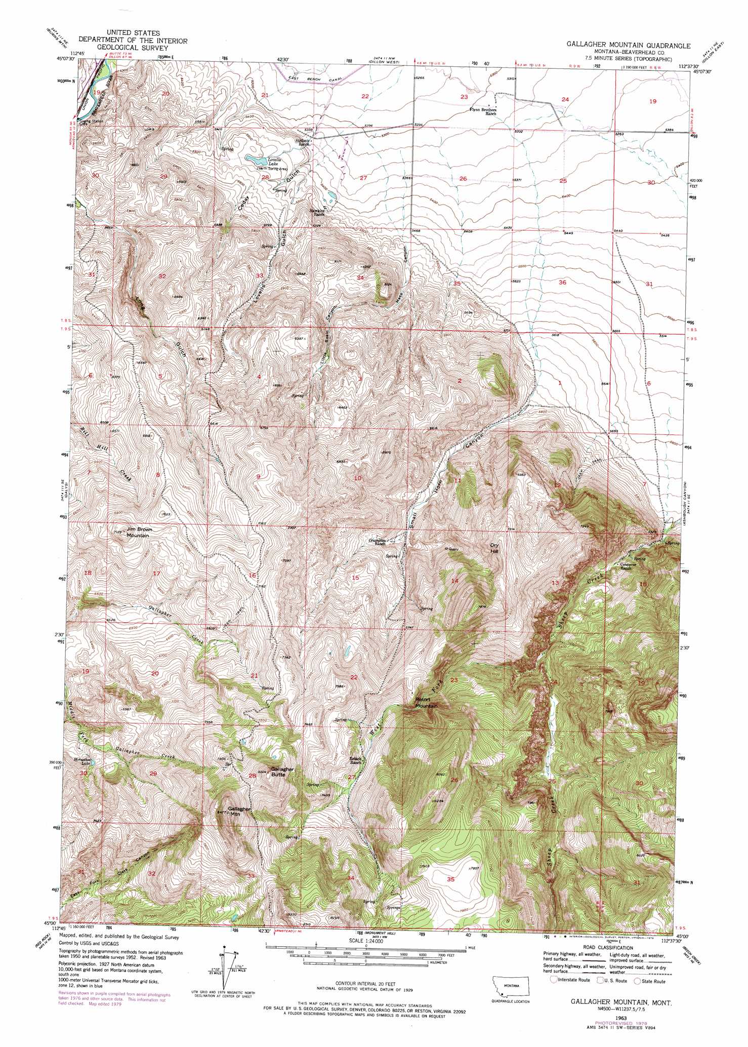
USGS Topo Quad 45112a6 - 1:24,000 scale
| Topo Map Name: | Gallagher Mountain |
| USGS Topo Quad ID: | 45112a6 |
| Print Size: | ca. 21 1/4" wide x 27" high |
| Southeast Coordinates: | 45° N latitude / 112.625° W longitude |
| Map Center Coordinates: | 45.0625° N latitude / 112.6875° W longitude |
| U.S. State: | MT |
| Filename: | o45112a6.jpg |
| Download Map JPG Image: | Gallagher Mountain topo map 1:24,000 scale |
| Map Type: | Topographic |
| Topo Series: | 7.5´ |
| Map Scale: | 1:24,000 |
| Source of Map Images: | United States Geological Survey (USGS) |
| Alternate Map Versions: |
Gallagher Mountain MT 1952, updated 1954 Download PDF Buy paper map Gallagher Mountain MT 1963, updated 1965 Download PDF Buy paper map Gallagher Mountain MT 1963, updated 1979 Download PDF Buy paper map Gallagher Mountain MT 2011 Download PDF Buy paper map Gallagher Mountain MT 2014 Download PDF Buy paper map |
1:24,000 Topo Quads surrounding Gallagher Mountain
Ermont |
Argenta |
Bond |
Glen Se |
Beaverhead Rock Sw |
Bannack |
Burns Mountain |
Dillon West |
Dillon East |
Christensen Ranch |
Eli Spring |
Dalys |
Gallagher Mountain |
Ashbough Canyon |
Elk Gulch |
Garfield Canyon |
Red Rock |
Monument Hill |
Beech Creek |
Price Creek |
Deer Canyon |
Kidd |
Briggs Ranch |
Rock Island Ranch |
Vinegar Hill |
> Back to 45112a1 at 1:100,000 scale
> Back to 45112a1 at 1:250,000 scale
> Back to U.S. Topo Maps home
Gallagher Mountain topo map: Gazetteer
Gallagher Mountain: Lakes
Horseshoe Lake elevation 2047m 6715′Lovells Lake elevation 1675m 5495′
Gallagher Mountain: Springs
09S08W18ABBD01 Spring elevation 1772m 5813′Gallagher Mountain: Streams
West Fork Sheep Creek elevation 1907m 6256′Gallagher Mountain: Summits
Dry Hill elevation 2233m 7326′Gallagher Butte elevation 2503m 8211′
Gallagher Mountain elevation 2585m 8480′
Jim Brown Mountain elevation 2173m 7129′
Retort Mountain elevation 2169m 7116′
Gallagher Mountain: Valleys
Cedar Gulch elevation 1611m 5285′Little Basin Canyon elevation 1769m 5803′
Lovells Gulch elevation 1628m 5341′
Mass Canyon elevation 1634m 5360′
Small Horn Canyon elevation 1752m 5748′
Gallagher Mountain: Wells
08S08W30CCCC01 Well elevation 1659m 5442′08S08W31CCAA01 Well elevation 1684m 5524′
08S08WCCCC02__ Well elevation 1658m 5439′
08S09W17DCBA01 Well elevation 2145m 7037′
08S09W23DADA_1 Well elevation 1620m 5314′
08S09W23DADA02 Well elevation 1620m 5314′
08S09W24CCCC01 Well elevation 1625m 5331′
08S09W24DCDC01 Well elevation 1631m 5351′
08S09W24DDDD01 Well elevation 1636m 5367′
08S09W25ADBA01 Well elevation 1641m 5383′
08S09W25BAAA01 Well elevation 1632m 5354′
08S09W26ABAB01 Well elevation 1622m 5321′
08S09W26BBD_01 Well elevation 1623m 5324′
09S08W07DBCC01 Well elevation 1731m 5679′
09S08W07DBDC01 Well elevation 1730m 5675′
09S08W07DCBB01 Well elevation 1734m 5688′
Gallagher Mountain digital topo map on disk
Buy this Gallagher Mountain topo map showing relief, roads, GPS coordinates and other geographical features, as a high-resolution digital map file on DVD: