Christensen Ranch Topo Map Montana
To zoom in, hover over the map of Christensen Ranch
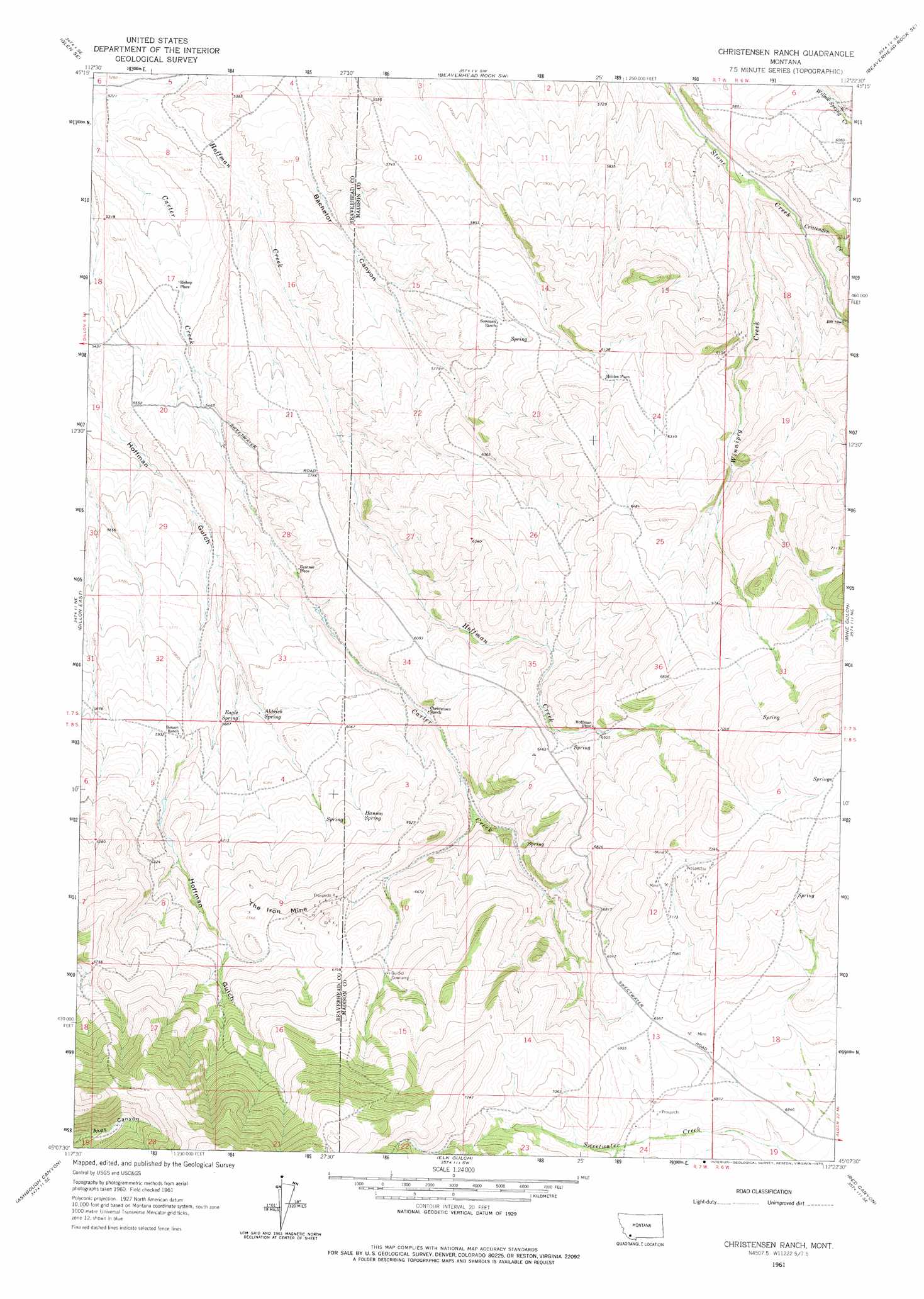
USGS Topo Quad 45112b4 - 1:24,000 scale
| Topo Map Name: | Christensen Ranch |
| USGS Topo Quad ID: | 45112b4 |
| Print Size: | ca. 21 1/4" wide x 27" high |
| Southeast Coordinates: | 45.125° N latitude / 112.375° W longitude |
| Map Center Coordinates: | 45.1875° N latitude / 112.4375° W longitude |
| U.S. State: | MT |
| Filename: | o45112b4.jpg |
| Download Map JPG Image: | Christensen Ranch topo map 1:24,000 scale |
| Map Type: | Topographic |
| Topo Series: | 7.5´ |
| Map Scale: | 1:24,000 |
| Source of Map Images: | United States Geological Survey (USGS) |
| Alternate Map Versions: |
Christensen Ranch MT 1961, updated 1964 Download PDF Buy paper map Christensen Ranch MT 1961, updated 1975 Download PDF Buy paper map Christensen Ranch MT 2011 Download PDF Buy paper map Christensen Ranch MT 2014 Download PDF Buy paper map |
1:24,000 Topo Quads surrounding Christensen Ranch
Glen |
Block Mountain |
Beaverhead Rock |
Beaverhead Rock Ne |
Sheridan |
Bond |
Glen Se |
Beaverhead Rock Sw |
Beaverhead Rock Se |
Laurin Canyon |
Dillon West |
Dillon East |
Christensen Ranch |
Mine Gulch |
Metzel Ranch |
Gallagher Mountain |
Ashbough Canyon |
Elk Gulch |
Red Canyon |
Belmont Park Ranch |
Monument Hill |
Beech Creek |
Price Creek |
Price Creek Ne |
Swamp Creek |
> Back to 45112a1 at 1:100,000 scale
> Back to 45112a1 at 1:250,000 scale
> Back to U.S. Topo Maps home
Christensen Ranch topo map: Gazetteer
Christensen Ranch: Dams
Abenson Dam elevation 1881m 6171′Christensen Ranch: Mines
Hoffman Place Mine elevation 2024m 6640′NW NE Section 12 Mine elevation 2209m 7247′
Regal Mine elevation 1984m 6509′
SE NE Section 13 Mine elevation 2125m 6971′
Christensen Ranch: Populated Places
Bishop Place elevation 1638m 5374′Guntner Place elevation 1731m 5679′
Hoffman Place elevation 1981m 6499′
Holden Place elevation 1877m 6158′
Christensen Ranch: Springs
Aldrich Spring elevation 1791m 5875′Eagle Spring elevation 1789m 5869′
Hanson Spring elevation 1900m 6233′
Christensen Ranch: Streams
Crittenden Creek elevation 1769m 5803′Winnipeg Creek elevation 1741m 5711′
Christensen Ranch: Summits
The Iron Mine elevation 2010m 6594′Christensen Ranch: Valleys
Bachelor Canyon elevation 1635m 5364′Christensen Ranch: Wells
07S06W07BBAD01 Well elevation 1793m 5882′Christensen Ranch digital topo map on disk
Buy this Christensen Ranch topo map showing relief, roads, GPS coordinates and other geographical features, as a high-resolution digital map file on DVD: