Dillon East Topo Map Montana
To zoom in, hover over the map of Dillon East
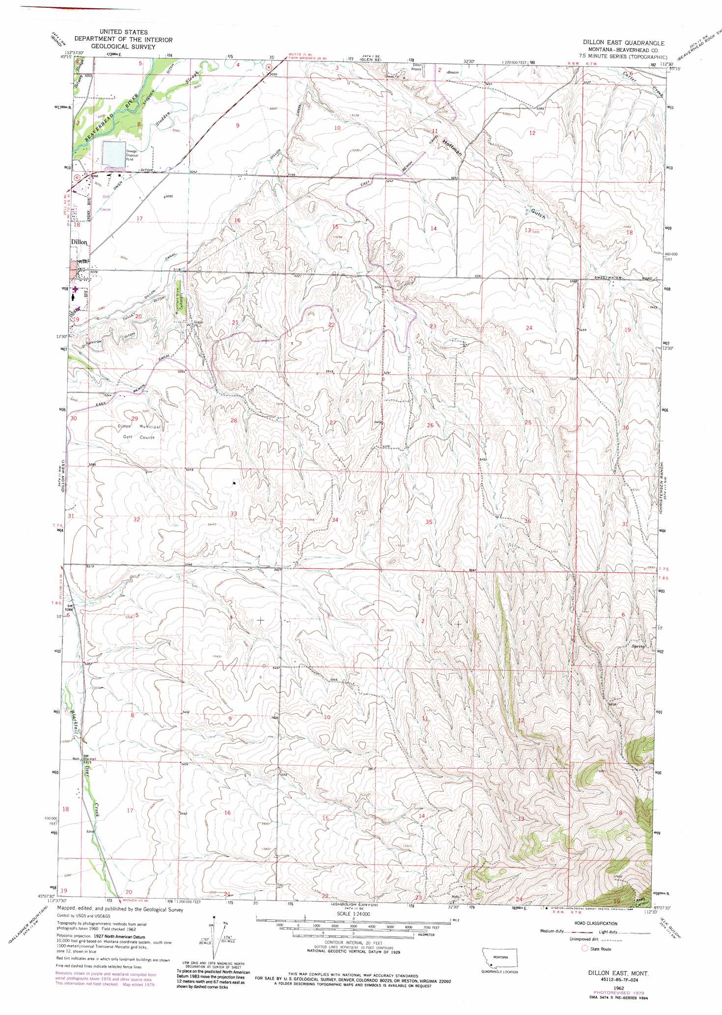
USGS Topo Quad 45112b5 - 1:24,000 scale
| Topo Map Name: | Dillon East |
| USGS Topo Quad ID: | 45112b5 |
| Print Size: | ca. 21 1/4" wide x 27" high |
| Southeast Coordinates: | 45.125° N latitude / 112.5° W longitude |
| Map Center Coordinates: | 45.1875° N latitude / 112.5625° W longitude |
| U.S. State: | MT |
| Filename: | o45112b5.jpg |
| Download Map JPG Image: | Dillon East topo map 1:24,000 scale |
| Map Type: | Topographic |
| Topo Series: | 7.5´ |
| Map Scale: | 1:24,000 |
| Source of Map Images: | United States Geological Survey (USGS) |
| Alternate Map Versions: |
Dillon East MT 1962, updated 1965 Download PDF Buy paper map Dillon East MT 1962, updated 1975 Download PDF Buy paper map Dillon East MT 1962, updated 1979 Download PDF Buy paper map Dillon East MT 1962, updated 1986 Download PDF Buy paper map Dillon East MT 2011 Download PDF Buy paper map Dillon East MT 2014 Download PDF Buy paper map |
1:24,000 Topo Quads surrounding Dillon East
Twin Adams Mountain |
Glen |
Block Mountain |
Beaverhead Rock |
Beaverhead Rock Ne |
Argenta |
Bond |
Glen Se |
Beaverhead Rock Sw |
Beaverhead Rock Se |
Burns Mountain |
Dillon West |
Dillon East |
Christensen Ranch |
Mine Gulch |
Dalys |
Gallagher Mountain |
Ashbough Canyon |
Elk Gulch |
Red Canyon |
Red Rock |
Monument Hill |
Beech Creek |
Price Creek |
Price Creek Ne |
> Back to 45112a1 at 1:100,000 scale
> Back to 45112a1 at 1:250,000 scale
> Back to U.S. Topo Maps home
Dillon East topo map: Gazetteer
Dillon East: Canals
Dillon Canal elevation 1555m 5101′Stodden Ditch elevation 1536m 5039′
Tulley Ditch elevation 1562m 5124′
Dillon East: Dams
Dillon Sewage Lagoon Dam elevation 1587m 5206′Dillon East: Mines
NW Section 24 Mine elevation 1914m 6279′Dillon East: Parks
Centennial Park elevation 1551m 5088′Dan Ibey Memorial Park elevation 1548m 5078′
Ray Lynch Park elevation 1543m 5062′
Dillon East: Populated Places
East Bench (historical) elevation 1578m 5177′Fairview (historical) elevation 1616m 5301′
Dillon East: Reservoirs
South Side Reservoir elevation 1906m 6253′Dillon East: Streams
Hoffman Creek elevation 1584m 5196′Dillon East: Valleys
Hoffman Gulch elevation 1547m 5075′Dillon East: Wells
07S08W10BBAC01 Well elevation 1538m 5045′07S08W11BBCB01 Well elevation 1557m 5108′
07S08W15ADC_01 Well elevation 1604m 5262′
07S08W16AACA01 Well elevation 1558m 5111′
07S08W16CAA_01 Well elevation 1567m 5141′
07S08W17DDC_02 Well elevation 1558m 5111′
07S08W19ADD_02 Well elevation 1550m 5085′
07S08W23CCA_01 Well elevation 1598m 5242′
07S08W29BBD_01 Well elevation 1591m 5219′
08S08W06ADDD01 Well elevation 1621m 5318′
08S08W07DAAC01 Well elevation 1611m 5285′
08S08W07DDDC01 Well elevation 1620m 5314′
08S08W07DDDD01 Well elevation 1620m 5314′
08S08W20ACCA01 Well elevation 1644m 5393′
Dillon East digital topo map on disk
Buy this Dillon East topo map showing relief, roads, GPS coordinates and other geographical features, as a high-resolution digital map file on DVD: