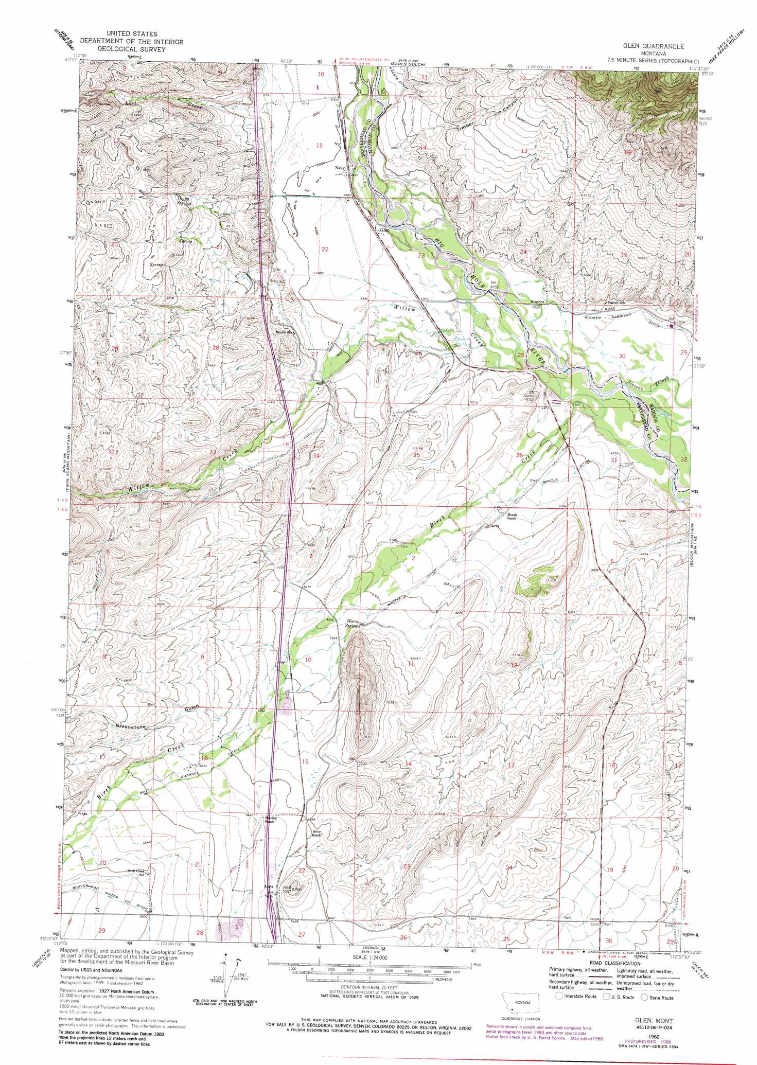
Glen Topo Map Montana
To zoom in, hover over the map of Glen
USGS Topo Quad 45112d6 - 1:24,000 scale
| Topo Map Name: | Glen |
| USGS Topo Quad ID: | 45112d6 |
| Print Size: | ca. 21 1/4" wide x 27" high |
| Southeast Coordinates: | 45.375° N latitude / 112.625° W longitude |
| Map Center Coordinates: | 45.4375° N latitude / 112.6875° W longitude |
| U.S. State: | MT |
| Filename: | o45112d6.jpg |
| Download Map JPG Image: | Glen topo map 1:24,000 scale |
| Map Type: | Topographic |
| Topo Series: | 7.5´ |
| Map Scale: | 1:24,000 |
| Source of Map Images: | United States Geological Survey (USGS) |
| Alternate Map Versions: |
Glen MT 1960, updated 1963 Download PDF Buy paper map Glen MT 1960, updated 1972 Download PDF Buy paper map Glen MT 1960, updated 1979 Download PDF Buy paper map Glen MT 1960, updated 1989 Download PDF Buy paper map Glen MT 1997, updated 2002 Download PDF Buy paper map Glen MT 2011 Download PDF Buy paper map Glen MT 2014 Download PDF Buy paper map |
| FStopo: | US Forest Service topo Glen is available: Download FStopo PDF Download FStopo TIF |
1:24,000 Topo Quads surrounding Glen
Vipond Park |
Cattle Gulch |
Melrose |
Wickiup Creek |
Table Mountain |
Mount Tahepia |
Storm Peak |
Earls Gulch |
Nez Perce Hollow |
Twin Bridges Sw |
Torrey Mountain |
Twin Adams Mountain |
Glen |
Block Mountain |
Beaverhead Rock |
Ermont |
Argenta |
Bond |
Glen Se |
Beaverhead Rock Sw |
Bannack |
Burns Mountain |
Dillon West |
Dillon East |
Christensen Ranch |
> Back to 45112a1 at 1:100,000 scale
> Back to 45112a1 at 1:250,000 scale
> Back to U.S. Topo Maps home
Glen topo map: Gazetteer
Glen: Bridges
Big Hole River Bridge elevation 1510m 4954′Glen: Canals
Beaverhead Water Company Ditch elevation 1716m 5629′Mantle Ditch elevation 1567m 5141′
South Channel Ditch elevation 1666m 5465′
Glen: Crossings
Interchange 74 elevation 1654m 5426′Glen: Mines
Glen Mine elevation 1721m 5646′Glen: Populated Places
Apex elevation 1657m 5436′Birch Creek (historical) elevation 1628m 5341′
Glen elevation 1520m 4986′
Navy elevation 1520m 4986′
Glen: Post Offices
Apex Post Office (historical) elevation 1657m 5436′Glen Post Office (historical) elevation 1520m 4986′
Oliver Post Office (historical) elevation 1628m 5341′
Glen: Springs
Warm Spring elevation 1599m 5246′Young Springs elevation 1618m 5308′
Glen: Streams
Birch Creek elevation 1499m 4917′Lost Creek elevation 1538m 5045′
Willow Creek elevation 1507m 4944′
Glen: Valleys
Greenstone Gulch elevation 1608m 5275′Timber Canyon elevation 1536m 5039′
Glen: Wells
04S09W25AAAA01 Well elevation 1516m 4973′Glen digital topo map on disk
Buy this Glen topo map showing relief, roads, GPS coordinates and other geographical features, as a high-resolution digital map file on DVD: