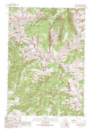
Noble Peak Topo Map Montana
To zoom in, hover over the map of Noble Peak
USGS Topo Quad 45112e1 - 1:24,000 scale
| Topo Map Name: | Noble Peak |
| USGS Topo Quad ID: | 45112e1 |
| Print Size: | ca. 21 1/4" wide x 27" high |
| Southeast Coordinates: | 45.5° N latitude / 112° W longitude |
| Map Center Coordinates: | 45.5625° N latitude / 112.0625° W longitude |
| U.S. State: | MT |
| Filename: | o45112e1.jpg |
| Download Map JPG Image: | Noble Peak topo map 1:24,000 scale |
| Map Type: | Topographic |
| Topo Series: | 7.5´ |
| Map Scale: | 1:24,000 |
| Source of Map Images: | United States Geological Survey (USGS) |
| Alternate Map Versions: |
Noble Peak MT 1989, updated 1989 Download PDF Buy paper map Noble Peak MT 1989, updated 1989 Download PDF Buy paper map Noble Peak MT 1997, updated 2002 Download PDF Buy paper map Noble Peak MT 2011 Download PDF Buy paper map Noble Peak MT 2014 Download PDF Buy paper map |
| FStopo: | US Forest Service topo Noble Peak is available: Download FStopo PDF Download FStopo TIF |
1:24,000 Topo Quads surrounding Noble Peak
> Back to 45112e1 at 1:100,000 scale
> Back to 45112a1 at 1:250,000 scale
> Back to U.S. Topo Maps home
Noble Peak topo map: Gazetteer
Noble Peak: Basins
Bow Basin elevation 2744m 9002′Noble Peak: Dams
Bell Lake Dam elevation 2666m 8746′Hill Reservoir Dam elevation 2600m 8530′
Jackson Number 1 Dam elevation 2991m 9812′
Noble Dam elevation 2706m 8877′
Sunrise Lake Dam elevation 2838m 9311′
Noble Peak: Flats
Buttertly Flats elevation 2496m 8188′Spring Park elevation 2273m 7457′
Spring Park Flat elevation 2237m 7339′
Noble Peak: Gaps
Mustard Pass elevation 2949m 9675′Spuhler Saddle elevation 2629m 8625′
Tom Graham Pass elevation 2308m 7572′
Noble Peak: Lakes
Blossom Lake elevation 2793m 9163′Brannan Lakes elevation 2818m 9245′
Crystal Lake elevation 2597m 8520′
Globe Lake elevation 2681m 8795′
Gneiss Lake elevation 2912m 9553′
Granite Lake elevation 2729m 8953′
Jackson Lake elevation 2659m 8723′
Lost Cabin Lake elevation 2762m 9061′
Louise Lake elevation 2702m 8864′
Macaroni Lake elevation 2547m 8356′
Noble Lake elevation 2751m 9025′
Oval Lake elevation 2741m 8992′
Rossiter Lake elevation 2680m 8792′
Sailor Lake elevation 2702m 8864′
Triangle Lake elevation 2768m 9081′
Twin Lakes elevation 2808m 9212′
Upper Boulder Lake elevation 2727m 8946′
Noble Peak: Mines
Bismark Mine elevation 2246m 7368′Brannan Lake Mine elevation 2832m 9291′
Helios Number 1/Big Tom Mine elevation 2399m 7870′
Independence Gulch Mine elevation 2388m 7834′
Lakeshore Mine elevation 2647m 8684′
Lakeshore Mine elevation 2597m 8520′
Leggat Creek Mine elevation 2754m 9035′
Leiter Mine elevation 2553m 8375′
Mount Jackson Mine elevation 2966m 9730′
NE NW Section 36 Mine elevation 2142m 7027′
Nicholson Mine elevation 2886m 9468′
Nicholson Mine elevation 2901m 9517′
Noble Mine elevation 2304m 7559′
Noble Mine elevation 2337m 7667′
NW NE Section 9 Mine elevation 2924m 9593′
Occidental Mine elevation 2621m 8599′
Occidental Mine elevation 2583m 8474′
Red Pine Mine elevation 2380m 7808′
Red Pine Mine elevation 2353m 7719′
Sailor Lake Mine elevation 2662m 8733′
SE NW Section 36 Mine elevation 2204m 7230′
Snyder Mine elevation 2749m 9019′
Snyders Mine elevation 2693m 8835′
South Fork Indian Creek Mine elevation 2643m 8671′
South Section 6 Mine elevation 2791m 9156′
Spuhler Gulch Mine elevation 2623m 8605′
Sunbeam Mine elevation 2783m 9130′
Sunbean Mine elevation 2820m 9251′
Sunnyside Mine elevation 2506m 8221′
Sunrise Lake Mine elevation 2858m 9376′
SW NE Section 12 Mine elevation 2573m 8441′
Upper Boulder Lake Mine elevation 2744m 9002′
Upper Lakeshore Mine elevation 2670m 8759′
Noble Peak: Populated Places
Leiterville elevation 2195m 7201′Noble Peak: Reservoirs
Bell Lake elevation 2665m 8743′Bismark Reservoir elevation 2305m 7562′
Hill Reservoir elevation 2623m 8605′
Jackson Lake elevation 2991m 9812′
Noble Lake elevation 2706m 8877′
Sunrise Lake elevation 2847m 9340′
Thompson Reservoir elevation 2729m 8953′
Ziegler Reservoir elevation 2547m 8356′
Noble Peak: Streams
North Fork Indian Creek elevation 2284m 7493′South Fork Indian Creek elevation 2278m 7473′
Noble Peak: Summits
A P A Mountain elevation 3167m 10390′Cloudrest Peak elevation 3050m 10006′
Granite Peak elevation 3218m 10557′
Hollowtop Mountain elevation 3216m 10551′
Horse Mountain elevation 3069m 10068′
Lakeshore Mountain elevation 3179m 10429′
Leggat Mountain elevation 3055m 10022′
Little Granite Peak elevation 3084m 10118′
Lonesome Peak elevation 3148m 10328′
Long Mountain elevation 3037m 9963′
Middle Mountain elevation 3109m 10200′
Mount Jackson elevation 3165m 10383′
Mount Jefferson elevation 3083m 10114′
Noble Peak elevation 3147m 10324′
Skihi Peak elevation 2886m 9468′
Spuhler Peak elevation 3113m 10213′
Sunrise Peak elevation 3025m 9924′
Thompson Peak elevation 3147m 10324′
Noble Peak: Trails
Lost Cabin Lake Recreation Trail elevation 2525m 8284′Louise Lake National Recreation Trail elevation 2548m 8359′
Noble Peak: Valleys
Independence Gulch elevation 2268m 7440′Montana Gulch elevation 2433m 7982′
Spuhler Gulch elevation 2248m 7375′
Noble Peak digital topo map on disk
Buy this Noble Peak topo map showing relief, roads, GPS coordinates and other geographical features, as a high-resolution digital map file on DVD:


