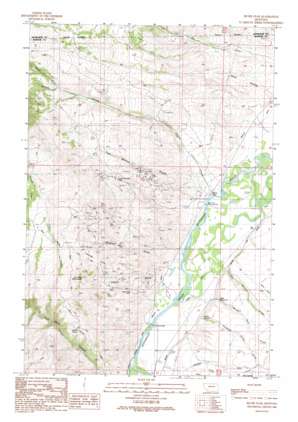
Silver Star Topo Map Montana
To zoom in, hover over the map of Silver Star
USGS Topo Quad 45112f3 - 1:24,000 scale
| Topo Map Name: | Silver Star |
| USGS Topo Quad ID: | 45112f3 |
| Print Size: | ca. 21 1/4" wide x 27" high |
| Southeast Coordinates: | 45.625° N latitude / 112.25° W longitude |
| Map Center Coordinates: | 45.6875° N latitude / 112.3125° W longitude |
| U.S. State: | MT |
| Filename: | o45112f3.jpg |
| Download Map JPG Image: | Silver Star topo map 1:24,000 scale |
| Map Type: | Topographic |
| Topo Series: | 7.5´ |
| Map Scale: | 1:24,000 |
| Source of Map Images: | United States Geological Survey (USGS) |
| Alternate Map Versions: |
Silver Star MT 1989, updated 1989 Download PDF Buy paper map Silver Star MT 1996, updated 1998 Download PDF Buy paper map Silver Star MT 2011 Download PDF Buy paper map Silver Star MT 2014 Download PDF Buy paper map |
| FStopo: | US Forest Service topo Silver Star is available: Download FStopo PDF Download FStopo TIF |
1:24,000 Topo Quads surrounding Silver Star
> Back to 45112e1 at 1:100,000 scale
> Back to 45112a1 at 1:250,000 scale
> Back to U.S. Topo Maps home
Silver Star topo map: Gazetteer
Silver Star: Bridges
Ironrod Bridge elevation 1385m 4543′Silver Star Bridge elevation 1379m 4524′
Silver Star: Canals
Creeklyn Ditch elevation 1384m 4540′Silver Star: Mines
Agalia Mine elevation 1800m 5905′Aurora Boraellis Mine elevation 1905m 6250′
Aurora Mine elevation 1831m 6007′
Aurora/Galena Mine elevation 1890m 6200′
Baccharat Mine elevation 1760m 5774′
Broadway/Victoria Mine elevation 1372m 4501′
Bull Dog Mine elevation 1762m 5780′
Chromite Mine elevation 1835m 6020′
Chromite Mine elevation 1810m 5938′
Clancy Mine elevation 1778m 5833′
Clifford Mine elevation 1831m 6007′
Clifford Mine elevation 1830m 6003′
Clipper Mine elevation 1672m 5485′
Clipper Mine elevation 1714m 5623′
Cricket Mine elevation 1651m 5416′
Cricket Mine elevation 1731m 5679′
Fagan Mine elevation 1524m 5000′
Frida Marie Mine elevation 1611m 5285′
Galena Mine elevation 1767m 5797′
Galena Mine elevation 1776m 5826′
Glenns Falls Mine elevation 1672m 5485′
Golden Antler Mine elevation 1508m 4947′
Golden Rod Mine elevation 1608m 5275′
Golden Rod Mine elevation 1578m 5177′
Green Campbell Mine elevation 1704m 5590′
Green-Campbell Mine elevation 1739m 5705′
Hells Canyon Mine elevation 1555m 5101′
Hudson Mine elevation 1600m 5249′
Iron Rod Extension Mine elevation 1723m 5652′
Iron Rod Mine elevation 1702m 5583′
Ironrod Mine elevation 1573m 5160′
Keystone Mine elevation 1610m 5282′
Keystone Mine elevation 1641m 5383′
Locust Mine elevation 1744m 5721′
MGV Mine elevation 1525m 5003′
Moonlight Mine elevation 1736m 5695′
Morning Mine elevation 1631m 5351′
NW NE Section 18 Mine elevation 1376m 4514′
NW Section 9 Mine elevation 2017m 6617′
Sage Hen Mine elevation 1839m 6033′
Sample Orr Mine elevation 1628m 5341′
SE Section 15 Mine elevation 1574m 5164′
Shamrock Mine elevation 1785m 5856′
Shamrock/Quincy Mine elevation 1779m 5836′
Silver Star Mine elevation 1844m 6049′
Star Mine elevation 1494m 4901′
Star Mines elevation 1716m 5629′
Stella Mine elevation 1878m 6161′
Stella/Golden Spike Mine elevation 1924m 6312′
SW Section 11 Mine elevation 1528m 5013′
Victoria Mine elevation 1617m 5305′
Silver Star: Populated Places
Iron Rod (historical) elevation 1385m 4543′Silver Star elevation 1393m 4570′
Silver Star: Post Offices
Crawford Post Office (historical) elevation 1392m 4566′Iron Rod Post Office (historical) elevation 1385m 4543′
Silver Star Post Office elevation 1393m 4570′
Silver Star: Reservoirs
Miller Reservoir elevation 1412m 4632′Nelson Reservoir elevation 1408m 4619′
Silver Star: Springs
01S06W33BAAD01 Spring elevation 1817m 5961′01S06W34CBDC01 Spring elevation 1720m 5643′
02S06W01CCCD01 Spring elevation 1429m 4688′
02S06W01CCCD02 Spring elevation 1429m 4688′
02S06W11DCDC01 Spring elevation 1476m 4842′
Hidden Spring elevation 1635m 5364′
Silver Star: Streams
Cherry Creek elevation 1379m 4524′Coal Creek elevation 1402m 4599′
Dry Boulder Creek elevation 1388m 4553′
Dry Creek elevation 1482m 4862′
Dry Creek elevation 1371m 4498′
First Creek elevation 1594m 5229′
North Fork Cherry Creek elevation 1814m 5951′
Spring Reef Creek elevation 1385m 4543′
Unnamed Spring Creek elevation 1389m 4557′
Silver Star: Summits
Bulldog Mountain elevation 1978m 6489′Ironrod Hills elevation 1800m 5905′
Silver Star: Valleys
Blackman Gulch elevation 1403m 4603′Clipper Gulch elevation 1391m 4563′
Sand Hollow elevation 1554m 5098′
Tom Benton Gulch elevation 1412m 4632′
Silver Star: Wells
02S06W01CDD_01 Well elevation 1386m 4547′02S06W12CCBC01 Well elevation 1401m 4596′
02S06W12CCCC01 Well elevation 1391m 4563′
Silver Star digital topo map on disk
Buy this Silver Star topo map showing relief, roads, GPS coordinates and other geographical features, as a high-resolution digital map file on DVD:


