Table Mountain Topo Map Montana
To zoom in, hover over the map of Table Mountain
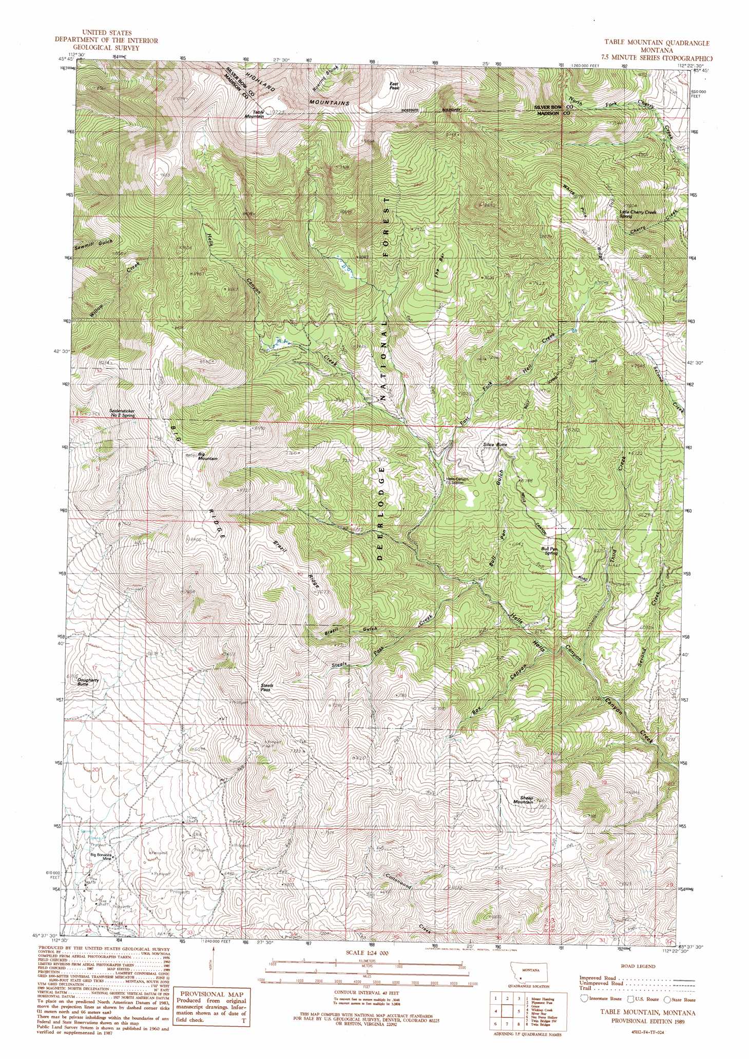
USGS Topo Quad 45112f4 - 1:24,000 scale
| Topo Map Name: | Table Mountain |
| USGS Topo Quad ID: | 45112f4 |
| Print Size: | ca. 21 1/4" wide x 27" high |
| Southeast Coordinates: | 45.625° N latitude / 112.375° W longitude |
| Map Center Coordinates: | 45.6875° N latitude / 112.4375° W longitude |
| U.S. State: | MT |
| Filename: | o45112f4.jpg |
| Download Map JPG Image: | Table Mountain topo map 1:24,000 scale |
| Map Type: | Topographic |
| Topo Series: | 7.5´ |
| Map Scale: | 1:24,000 |
| Source of Map Images: | United States Geological Survey (USGS) |
| Alternate Map Versions: |
Table Mountain MT 1989, updated 1989 Download PDF Buy paper map Table Mountain MT 1996, updated 1998 Download PDF Buy paper map Table Mountain MT 2011 Download PDF Buy paper map Table Mountain MT 2014 Download PDF Buy paper map |
| FStopo: | US Forest Service topo Table Mountain is available: Download FStopo PDF Download FStopo TIF |
1:24,000 Topo Quads surrounding Table Mountain
Buxton |
Butte South |
Homestake |
Delmoe Lake |
Dry Mountain |
Tucker Creek |
Mount Humbug |
Pipestone Pass |
Grace |
Vendome |
Melrose |
Wickiup Creek |
Table Mountain |
Silver Star |
Waterloo |
Earls Gulch |
Nez Perce Hollow |
Twin Bridges Sw |
Twin Bridges |
Old Baldy Mountain |
Glen |
Block Mountain |
Beaverhead Rock |
Beaverhead Rock Ne |
Sheridan |
> Back to 45112e1 at 1:100,000 scale
> Back to 45112a1 at 1:250,000 scale
> Back to U.S. Topo Maps home
Table Mountain topo map: Gazetteer
Table Mountain: Gaps
Steels Pass elevation 2260m 7414′Table Mountain: Mines
Big Bonanza Mine elevation 1858m 6095′Elgin Mine elevation 1812m 5944′
Julia Lee Mine elevation 1879m 6164′
NE Section 32 Mine elevation 1837m 6026′
SW Section 29 Mine elevation 1824m 5984′
Table Mountain: Ranges
Highland Mountains elevation 2768m 9081′Table Mountain: Ridges
Big Ridge elevation 2466m 8090′Brazil Ridge elevation 2357m 7732′
The Bar elevation 2421m 7942′
White Pine Ridge elevation 2433m 7982′
Table Mountain: Springs
Bull Pen Spring elevation 1978m 6489′Little Cherry Creek Springs elevation 2313m 7588′
Seidensticker Number Two Spring elevation 2533m 8310′
Table Mountain: Streams
East Fork Hell Creek elevation 2000m 6561′Second Creek elevation 1964m 6443′
Steels Pass Creek elevation 1872m 6141′
Third Creek elevation 1772m 5813′
Table Mountain: Summits
Big Mountain elevation 2682m 8799′Big Sheep Mountain elevation 2186m 7171′
Dougherty Butte elevation 2042m 6699′
East Peak elevation 3017m 9898′
Grassy Mountain elevation 2616m 8582′
Little Sheep Mountain elevation 2090m 6856′
Red Mountain elevation 3055m 10022′
Silica Butte elevation 2116m 6942′
Table Mountain elevation 3113m 10213′
West Peak elevation 2944m 9658′
Table Mountain: Trails
Billy Johns Trail elevation 2215m 7267′Brazil Pack Trail elevation 2197m 7208′
Table Mountain: Valleys
Box Canyon elevation 1816m 5958′Brazil Gulch elevation 1994m 6541′
Bull Pen elevation 1870m 6135′
Bull Pen Gulch elevation 1822m 5977′
Hells Canyon elevation 1722m 5649′
Sawmill Gulch elevation 1866m 6122′
Table Mountain digital topo map on disk
Buy this Table Mountain topo map showing relief, roads, GPS coordinates and other geographical features, as a high-resolution digital map file on DVD: