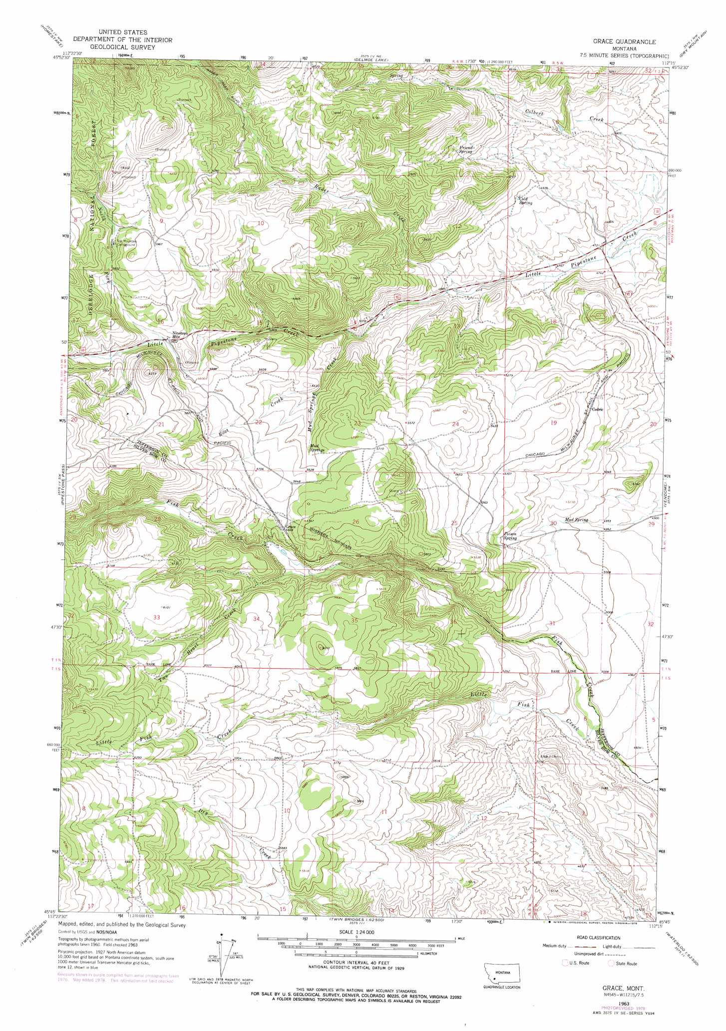
Grace Topo Map Montana
To zoom in, hover over the map of Grace
USGS Topo Quad 45112g3 - 1:24,000 scale
| Topo Map Name: | Grace |
| USGS Topo Quad ID: | 45112g3 |
| Print Size: | ca. 21 1/4" wide x 27" high |
| Southeast Coordinates: | 45.75° N latitude / 112.25° W longitude |
| Map Center Coordinates: | 45.8125° N latitude / 112.3125° W longitude |
| U.S. State: | MT |
| Filename: | o45112g3.jpg |
| Download Map JPG Image: | Grace topo map 1:24,000 scale |
| Map Type: | Topographic |
| Topo Series: | 7.5´ |
| Map Scale: | 1:24,000 |
| Source of Map Images: | United States Geological Survey (USGS) |
| Alternate Map Versions: |
Grace MT 1963, updated 1966 Download PDF Buy paper map Grace MT 1963, updated 1975 Download PDF Buy paper map Grace MT 1963, updated 1978 Download PDF Buy paper map Grace MT 1996, updated 1998 Download PDF Buy paper map Grace MT 2011 Download PDF Buy paper map Grace MT 2014 Download PDF Buy paper map |
| FStopo: | US Forest Service topo Grace is available: Download FStopo PDF Download FStopo TIF |
1:24,000 Topo Quads surrounding Grace
Butte North |
Elk Park Pass |
Whitetail Peak |
Ratio Mountain |
Wilson Park |
Butte South |
Homestake |
Delmoe Lake |
Dry Mountain |
Black Butte |
Mount Humbug |
Pipestone Pass |
Grace |
Vendome |
Whitehall |
Wickiup Creek |
Table Mountain |
Silver Star |
Waterloo |
Manhead Mountain |
Nez Perce Hollow |
Twin Bridges Sw |
Twin Bridges |
Old Baldy Mountain |
Noble Peak |
> Back to 45112e1 at 1:100,000 scale
> Back to 45112a1 at 1:250,000 scale
> Back to U.S. Topo Maps home
Grace topo map: Gazetteer
Grace: Mines
NE SW Section 14 Mine elevation 1559m 5114′SE SW Section 7 Mine elevation 1459m 4786′
Grace: Populated Places
Cedric elevation 1584m 5196′Grace elevation 1730m 5675′
Grace: Post Offices
Grace Post Office (historical) elevation 1730m 5675′Grace: Springs
Cold Spring elevation 1524m 5000′Friend Spring elevation 1634m 5360′
Mud Spring elevation 1530m 5019′
Mud Springs elevation 1697m 5567′
Poison Spring elevation 1593m 5226′
Grace: Streams
Colbert Creek elevation 1422m 4665′Little Fish Creek elevation 1490m 4888′
Mud Springs Creek elevation 1563m 5127′
North Fork Little Pipestone Creek elevation 1719m 5639′
Rader Creek elevation 1477m 4845′
Root Creek elevation 1650m 5413′
Two Heart Creek elevation 1659m 5442′
Grace digital topo map on disk
Buy this Grace topo map showing relief, roads, GPS coordinates and other geographical features, as a high-resolution digital map file on DVD: