Buxton Topo Map Montana
To zoom in, hover over the map of Buxton
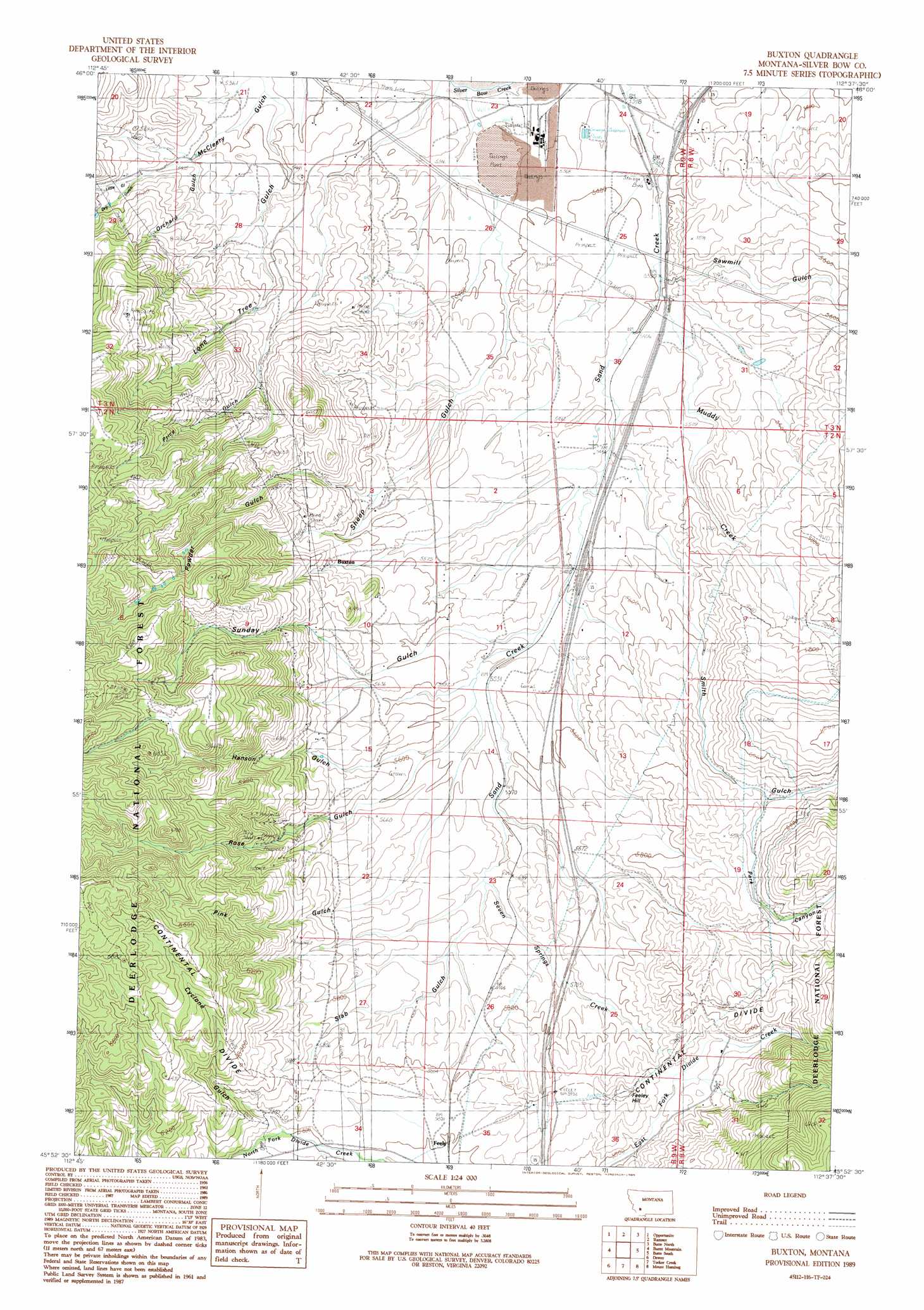
USGS Topo Quad 45112h6 - 1:24,000 scale
| Topo Map Name: | Buxton |
| USGS Topo Quad ID: | 45112h6 |
| Print Size: | ca. 21 1/4" wide x 27" high |
| Southeast Coordinates: | 45.875° N latitude / 112.625° W longitude |
| Map Center Coordinates: | 45.9375° N latitude / 112.6875° W longitude |
| U.S. State: | MT |
| Filename: | o45112h6.jpg |
| Download Map JPG Image: | Buxton topo map 1:24,000 scale |
| Map Type: | Topographic |
| Topo Series: | 7.5´ |
| Map Scale: | 1:24,000 |
| Source of Map Images: | United States Geological Survey (USGS) |
| Alternate Map Versions: |
Buxton MT 1989, updated 1989 Download PDF Buy paper map Buxton MT 1996, updated 1998 Download PDF Buy paper map Buxton MT 2011 Download PDF Buy paper map Buxton MT 2014 Download PDF Buy paper map |
| FStopo: | US Forest Service topo Buxton is available: Download FStopo PDF Download FStopo TIF |
1:24,000 Topo Quads surrounding Buxton
Anaconda North |
Warm Springs |
Orofino Mountain |
Lockhart Meadows |
Sheepshead Mountain |
Anaconda South |
Opportunity |
Ramsay |
Butte North |
Elk Park Pass |
Dickie Peak |
Burnt Mountain |
Buxton |
Butte South |
Homestake |
Wise River |
Dewey |
Tucker Creek |
Mount Humbug |
Pipestone Pass |
Vipond Park |
Cattle Gulch |
Melrose |
Wickiup Creek |
Table Mountain |
> Back to 45112e1 at 1:100,000 scale
> Back to 45112a1 at 1:250,000 scale
> Back to U.S. Topo Maps home
Buxton topo map: Gazetteer
Buxton: Crossings
Interchange 116 elevation 1671m 5482′Interchange 119 elevation 1646m 5400′
Buxton: Dams
Stauffer Chemical Number 1 Dam elevation 1634m 5360′Buxton: Gaps
Deer Lodge Pass elevation 1805m 5921′Buxton: Mines
NW NE Section 32 Mine elevation 1916m 6286′Buxton: Populated Places
Buxton elevation 1753m 5751′Feely elevation 1768m 5800′
Buxton: Post Offices
Feeley Post Office (historical) elevation 1768m 5800′Silverbow Post Office (historical) elevation 1635m 5364′
Buxton: Ridges
Sunday Ridge elevation 1976m 6482′Buxton: Streams
Muddy Creek elevation 1643m 5390′Seven Springs Creek elevation 1697m 5567′
Buxton: Summits
Feeley Hill elevation 1830m 6003′Buxton: Valleys
Cyclone Gulch elevation 1800m 5905′Dry Gulch elevation 1671m 5482′
Hanson Gulch elevation 1695m 5561′
Little Gulch elevation 1671m 5482′
Lone Tree Gulch elevation 1635m 5364′
Orchard Gulch elevation 1654m 5426′
Park Canyon elevation 1787m 5862′
Pink Gulch elevation 1698m 5570′
Powder Gulch elevation 1692m 5551′
Price Gulch elevation 1683m 5521′
Rose Gulch elevation 1695m 5561′
Sawmill Gulch elevation 1646m 5400′
Sheep Gulch elevation 1646m 5400′
Slab Gulch elevation 1727m 5666′
Smith Gulch elevation 1677m 5501′
Sunday Gulch elevation 1679m 5508′
Buxton digital topo map on disk
Buy this Buxton topo map showing relief, roads, GPS coordinates and other geographical features, as a high-resolution digital map file on DVD: