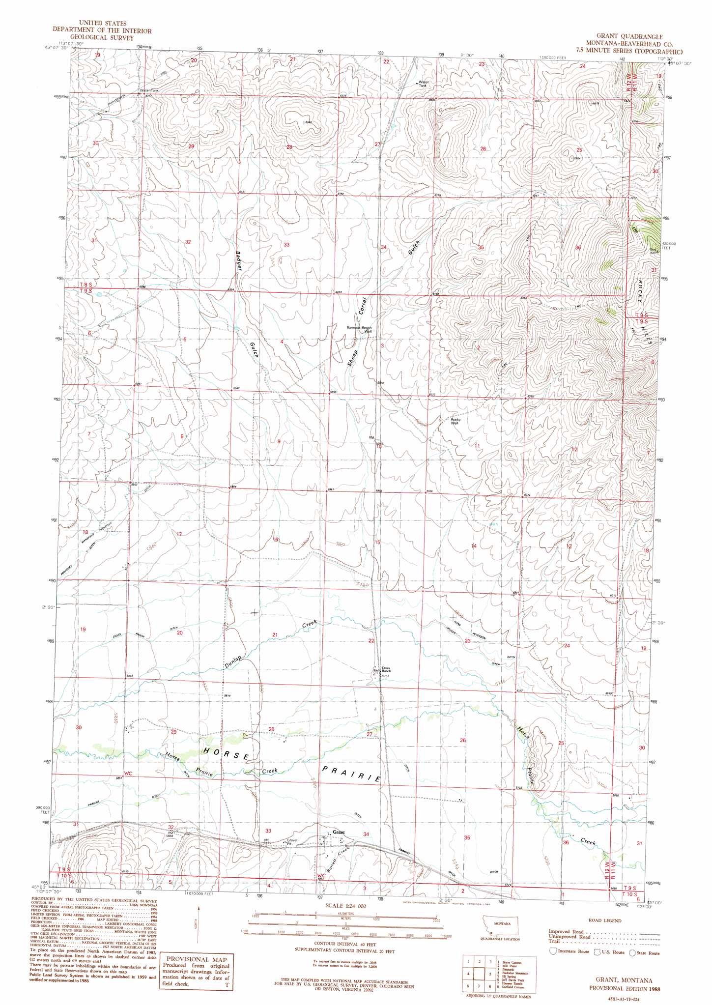
Grant Topo Map Montana
To zoom in, hover over the map of Grant
USGS Topo Quad 45113a1 - 1:24,000 scale
| Topo Map Name: | Grant |
| USGS Topo Quad ID: | 45113a1 |
| Print Size: | ca. 21 1/4" wide x 27" high |
| Southeast Coordinates: | 45° N latitude / 113° W longitude |
| Map Center Coordinates: | 45.0625° N latitude / 113.0625° W longitude |
| U.S. State: | MT |
| Filename: | o45113a1.jpg |
| Download Map JPG Image: | Grant topo map 1:24,000 scale |
| Map Type: | Topographic |
| Topo Series: | 7.5´ |
| Map Scale: | 1:24,000 |
| Source of Map Images: | United States Geological Survey (USGS) |
| Alternate Map Versions: |
Grant MT 1988, updated 1989 Download PDF Buy paper map Grant MT 2011 Download PDF Buy paper map Grant MT 2014 Download PDF Buy paper map |
1:24,000 Topo Quads surrounding Grant
Butch Hill |
Tash Peak |
Polaris |
Ermont |
Argenta |
Peterson Lake |
Brays Canyon |
Mill Point |
Bannack |
Burns Mountain |
Coyote Creek |
Bachelor Mountain |
Grant |
Eli Spring |
Dalys |
Everson Creek |
Jeff Davis Peak |
Hansen Ranch |
Garfield Canyon |
Red Rock |
Bannock Pass |
Deadman Pass |
Medicine Lodge Peak |
Deer Canyon |
Kidd |
> Back to 45113a1 at 1:100,000 scale
> Back to 45112a1 at 1:250,000 scale
> Back to U.S. Topo Maps home
Grant topo map: Gazetteer
Grant: Canals
Cross Ranch Ditch elevation 1785m 5856′Hans Peterson Ditch elevation 1761m 5777′
Jagger Ditch elevation 1752m 5748′
Paiment Ditch elevation 1763m 5784′
Grant: Flats
Horse Prairie elevation 1781m 5843′Grant: Populated Places
Grant elevation 1772m 5813′Grant: Post Offices
Amesville Post Office (historical) elevation 1797m 5895′Grant Post Office (historical) elevation 1772m 5813′
Grant: Streams
Barrett Creek elevation 1760m 5774′Dunlap Creek elevation 1748m 5734′
Grant: Valleys
Badger Gulch elevation 1769m 5803′Sheep Corral Gulch elevation 1768m 5800′
Grant: Wells
08S12W32CDDD01 Well elevation 1841m 6040′09S12W03BDAC01 Well elevation 1834m 6017′
09S12W08ACDA01 Well elevation 1807m 5928′
09S12W11BBDD01 Well elevation 1836m 6023′
09S12W13ACBD01 Well elevation 1847m 6059′
09S12W14ACAD01 Well elevation 1820m 5971′
09S12W18DDAD01 Well elevation 1788m 5866′
09S12W18DDAD02 Well elevation 1789m 5869′
09S12W22DCBB01 Well elevation 1757m 5764′
09S12W22DCBD01 Well elevation 1756m 5761′
09S12W22DCBD02 Well elevation 1756m 5761′
09S12W29CBBB01 Well elevation 1786m 5859′
09S12W33DAAA01 Well elevation 1774m 5820′
09S12W34CBAB01 Well elevation 1772m 5813′
Bannock Bench Well elevation 1836m 6023′
Rocky Well elevation 1838m 6030′
Grant digital topo map on disk
Buy this Grant topo map showing relief, roads, GPS coordinates and other geographical features, as a high-resolution digital map file on DVD: