Bachelor Mountain Topo Map Montana
To zoom in, hover over the map of Bachelor Mountain
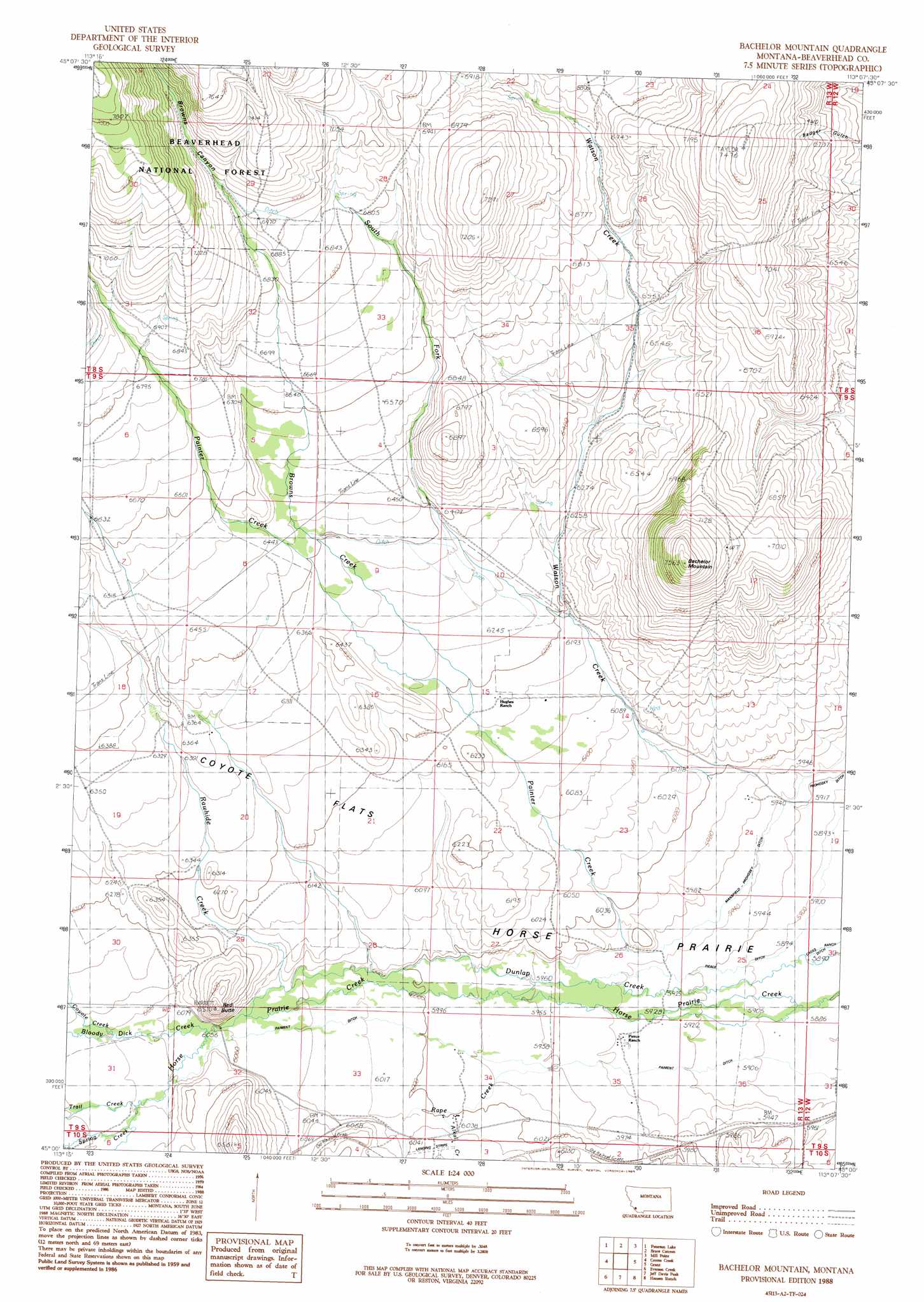
USGS Topo Quad 45113a2 - 1:24,000 scale
| Topo Map Name: | Bachelor Mountain |
| USGS Topo Quad ID: | 45113a2 |
| Print Size: | ca. 21 1/4" wide x 27" high |
| Southeast Coordinates: | 45° N latitude / 113.125° W longitude |
| Map Center Coordinates: | 45.0625° N latitude / 113.1875° W longitude |
| U.S. State: | MT |
| Filename: | o45113a2.jpg |
| Download Map JPG Image: | Bachelor Mountain topo map 1:24,000 scale |
| Map Type: | Topographic |
| Topo Series: | 7.5´ |
| Map Scale: | 1:24,000 |
| Source of Map Images: | United States Geological Survey (USGS) |
| Alternate Map Versions: |
Bachelor Mountain MT 1988, updated 1989 Download PDF Buy paper map Bachelor Mountain MT 1997, updated 2002 Download PDF Buy paper map Bachelor Mountain MT 2011 Download PDF Buy paper map Bachelor Mountain MT 2014 Download PDF Buy paper map |
| FStopo: | US Forest Service topo Bachelor Mountain is available: Download FStopo PDF Download FStopo TIF |
1:24,000 Topo Quads surrounding Bachelor Mountain
Jackson |
Butch Hill |
Tash Peak |
Polaris |
Ermont |
Selway Mountain |
Peterson Lake |
Brays Canyon |
Mill Point |
Bannack |
Kitty Creek |
Coyote Creek |
Bachelor Mountain |
Grant |
Eli Spring |
Lemhi Pass |
Everson Creek |
Jeff Davis Peak |
Hansen Ranch |
Garfield Canyon |
Goat Mountain |
Bannock Pass |
Deadman Pass |
Medicine Lodge Peak |
Deer Canyon |
> Back to 45113a1 at 1:100,000 scale
> Back to 45112a1 at 1:250,000 scale
> Back to U.S. Topo Maps home
Bachelor Mountain topo map: Gazetteer
Bachelor Mountain: Canals
Mansfield-Prohosky Ditch elevation 1810m 5938′Pierce Ditch elevation 1803m 5915′
Prohosky Ditch elevation 1805m 5921′
Bachelor Mountain: Flats
Coyote Flats elevation 1924m 6312′Bachelor Mountain: Mines
Pierce Ranch Mine elevation 1830m 6003′Bachelor Mountain: Streams
Alkali Creek elevation 1831m 6007′Bloody Dick Creek elevation 1855m 6085′
Browns Creek elevation 1883m 6177′
Coyote Creek elevation 1864m 6115′
Painter Creek elevation 1818m 5964′
Rape Creek elevation 1818m 5964′
Rawhide Creek elevation 1848m 6062′
South Fork Watson Creek elevation 1884m 6181′
Spring Creek elevation 1864m 6115′
Spring Creek elevation 1863m 6112′
Trail Creek elevation 1865m 6118′
Watson Creek elevation 1830m 6003′
Bachelor Mountain: Summits
Bachelor Mountan elevation 2298m 7539′Red Butte elevation 1994m 6541′
Bachelor Mountain: Swamps
Poverty Flats elevation 1946m 6384′Bachelor Mountain: Valleys
Browns Canyon elevation 2125m 6971′Bachelor Mountain: Wells
09S12W06BBCD01 Well elevation 1941m 6368′09S13W08AA__01 Well elevation 1971m 6466′
09S13W14DBAB01 Well elevation 1880m 6167′
09S13W15CDCC01 Well elevation 1893m 6210′
09S13W35ABCB01 Well elevation 1813m 5948′
10S13W03BBAA01 Well elevation 1844m 6049′
Bachelor Mountain digital topo map on disk
Buy this Bachelor Mountain topo map showing relief, roads, GPS coordinates and other geographical features, as a high-resolution digital map file on DVD: