Sal Mountain Topo Map Idaho
To zoom in, hover over the map of Sal Mountain
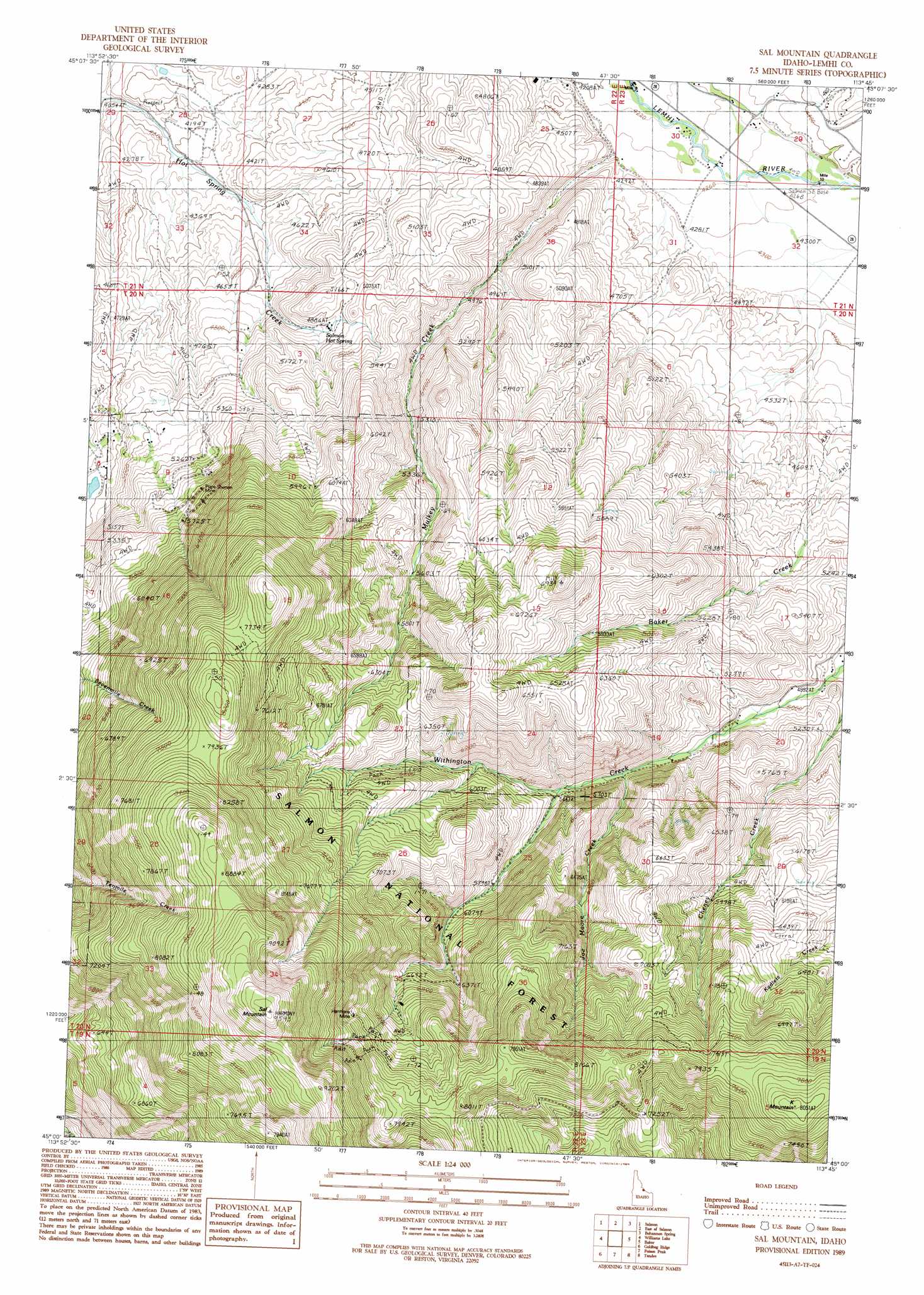
USGS Topo Quad 45113a7 - 1:24,000 scale
| Topo Map Name: | Sal Mountain |
| USGS Topo Quad ID: | 45113a7 |
| Print Size: | ca. 21 1/4" wide x 27" high |
| Southeast Coordinates: | 45° N latitude / 113.75° W longitude |
| Map Center Coordinates: | 45.0625° N latitude / 113.8125° W longitude |
| U.S. State: | ID |
| Filename: | o45113a7.jpg |
| Download Map JPG Image: | Sal Mountain topo map 1:24,000 scale |
| Map Type: | Topographic |
| Topo Series: | 7.5´ |
| Map Scale: | 1:24,000 |
| Source of Map Images: | United States Geological Survey (USGS) |
| Alternate Map Versions: |
Sal Mountain ID 1989, updated 1989 Download PDF Buy paper map Sal Mountain ID 2011 Download PDF Buy paper map Sal Mountain ID 2013 Download PDF Buy paper map |
| FStopo: | US Forest Service topo Sal Mountain is available: Download FStopo PDF Download FStopo TIF |
1:24,000 Topo Quads surrounding Sal Mountain
Napoleon Hill |
Bird Creek |
Badger Spring Gulch |
Homer Youngs Peak |
Miner Lake |
Leesburg |
Salmon |
East Of Salmon |
Bohannon Spring |
Goldstone Pass |
Lake Mountain |
Williams Lake |
Sal Mountain |
Baker |
Goldstone Mountain |
Degan Mountain |
Goldbug Ridge |
Poison Peak |
Tendoy |
Agency Creek |
Hat Creek |
Allison Creek |
Lem Peak |
Hayden Creek |
Lemhi |
> Back to 45113a1 at 1:100,000 scale
> Back to 45112a1 at 1:250,000 scale
> Back to U.S. Topo Maps home
Sal Mountain topo map: Gazetteer
Sal Mountain: Mines
Harmony Mine elevation 2317m 7601′Pope Shenon Mine elevation 1774m 5820′
Sal Mountain: Springs
Salmon Hot Spring elevation 1499m 4917′Sal Mountain: Streams
Cheney Creek elevation 1481m 4858′Hot Spring Creek elevation 1256m 4120′
Joe Moore Creek elevation 1655m 5429′
Mulkey Creek elevation 1318m 4324′
Sal Mountain: Summits
K Mountain elevation 2437m 7995′Sal Mountain elevation 2915m 9563′
Sal Mountain digital topo map on disk
Buy this Sal Mountain topo map showing relief, roads, GPS coordinates and other geographical features, as a high-resolution digital map file on DVD: