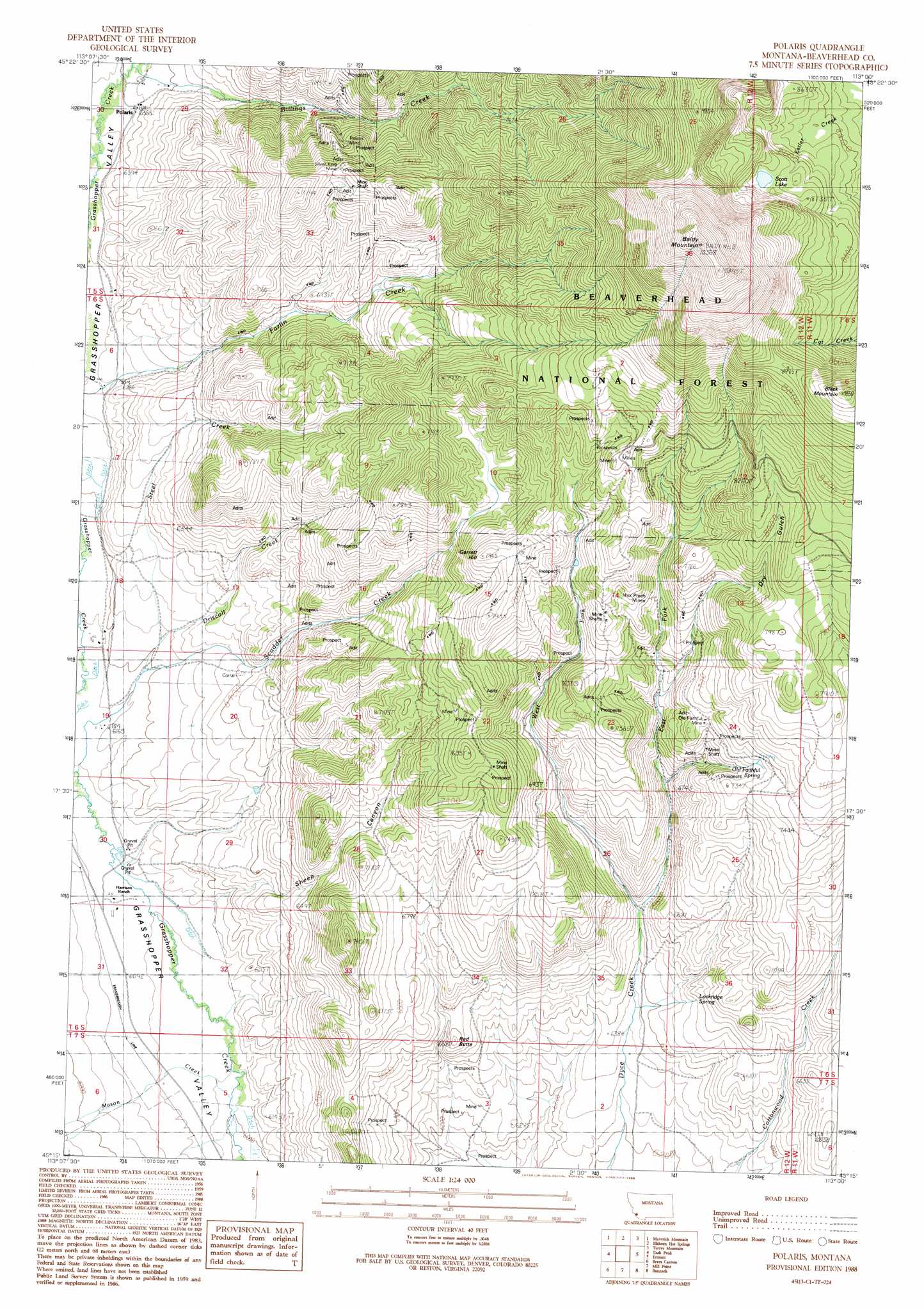
Polaris Topo Map Montana
To zoom in, hover over the map of Polaris
USGS Topo Quad 45113c1 - 1:24,000 scale
| Topo Map Name: | Polaris |
| USGS Topo Quad ID: | 45113c1 |
| Print Size: | ca. 21 1/4" wide x 27" high |
| Southeast Coordinates: | 45.25° N latitude / 113° W longitude |
| Map Center Coordinates: | 45.3125° N latitude / 113.0625° W longitude |
| U.S. State: | MT |
| Filename: | o45113c1.jpg |
| Download Map JPG Image: | Polaris topo map 1:24,000 scale |
| Map Type: | Topographic |
| Topo Series: | 7.5´ |
| Map Scale: | 1:24,000 |
| Source of Map Images: | United States Geological Survey (USGS) |
| Alternate Map Versions: |
Polaris MT 1988, updated 1989 Download PDF Buy paper map Polaris MT 1997, updated 2002 Download PDF Buy paper map Polaris MT 2011 Download PDF Buy paper map Polaris MT 2014 Download PDF Buy paper map |
| FStopo: | US Forest Service topo Polaris is available: Download FStopo PDF Download FStopo TIF |
1:24,000 Topo Quads surrounding Polaris
Stewart Mountain |
Odell Lake |
Maurice Mountain |
Mount Tahepia |
Storm Peak |
Jackson Hill |
Maverick Mountain |
Elkhorn Hot Springs |
Torrey Mountain |
Twin Adams Mountain |
Butch Hill |
Tash Peak |
Polaris |
Ermont |
Argenta |
Peterson Lake |
Brays Canyon |
Mill Point |
Bannack |
Burns Mountain |
Coyote Creek |
Bachelor Mountain |
Grant |
Eli Spring |
Dalys |
> Back to 45113a1 at 1:100,000 scale
> Back to 45112a1 at 1:250,000 scale
> Back to U.S. Topo Maps home
Polaris topo map: Gazetteer
Polaris: Areas
Yellowstone Plateau elevation 2264m 7427′Polaris: Lakes
Scott Lake elevation 2654m 8707′Polaris: Mines
Argentite Mine elevation 2098m 6883′Baldy Number 4/Hazel Mine elevation 2465m 8087′
Cable Mine elevation 2285m 7496′
Capital Mine elevation 2149m 7050′
Dillon Mine elevation 2216m 7270′
Driscoll Creek Mine elevation 2165m 7103′
Durham Bull Mine elevation 2213m 7260′
East Polaris Mine elevation 2257m 7404′
Echo Mine elevation 2427m 7962′
Garrett Hill Mine elevation 2334m 7657′
Grizzly Bear Mine elevation 2142m 7027′
Little Bell Mine elevation 2267m 7437′
Mayflower Mine elevation 2255m 7398′
Nick Preen Mine elevation 2226m 7303′
Nick Preen Mines elevation 2244m 7362′
Old Faithful Mine elevation 2211m 7253′
Polaris Mine elevation 2177m 7142′
Polaris Mine elevation 2190m 7185′
Silver King Mine elevation 2299m 7542′
Silver King Mine elevation 2291m 7516′
Steel Creek Mine elevation 2062m 6765′
Swanson Cabin Mine elevation 2142m 7027′
West Fork Mine elevation 2142m 7027′
Wild Bat Mine elevation 2287m 7503′
Polaris: Populated Places
Polaris elevation 1936m 6351′Polaris: Post Offices
Polaris Post Office (historical) elevation 1936m 6351′Polaris: Springs
Lockridge Spring elevation 2003m 6571′Old Faithful Spring elevation 2238m 7342′
Polaris: Streams
Billings Creek elevation 1935m 6348′Driscoll Creek elevation 1884m 6181′
East Fork Dyce Creek elevation 1973m 6473′
Mason Creek elevation 1836m 6023′
Steel Creek elevation 1890m 6200′
West Fork Dyce Creek elevation 1972m 6469′
Polaris: Summits
Baldy Mountain elevation 3211m 10534′Black Mountain elevation 2844m 9330′
Garrett Hill elevation 2416m 7926′
Red Butte elevation 2023m 6637′
Polaris: Valleys
Dry Gulch elevation 2166m 7106′Sheep Canyon elevation 1866m 6122′
Polaris: Wells
05S12W29BCDC01 Well elevation 1946m 6384′05S12W31DDDD01 Well elevation 1916m 6286′
06S12W31ABBA01 Well elevation 1863m 6112′
07S12W06DACB01 Well elevation 1871m 6138′
07S12W14DCCC01 Well elevation 1982m 6502′
Polaris digital topo map on disk
Buy this Polaris topo map showing relief, roads, GPS coordinates and other geographical features, as a high-resolution digital map file on DVD: