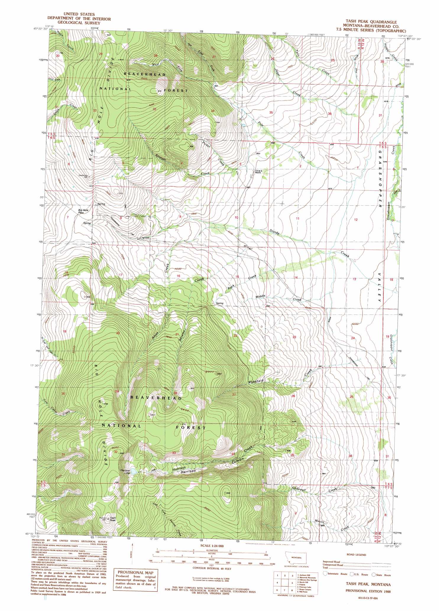
Tash Peak Topo Map Montana
To zoom in, hover over the map of Tash Peak
USGS Topo Quad 45113c2 - 1:24,000 scale
| Topo Map Name: | Tash Peak |
| USGS Topo Quad ID: | 45113c2 |
| Print Size: | ca. 21 1/4" wide x 27" high |
| Southeast Coordinates: | 45.25° N latitude / 113.125° W longitude |
| Map Center Coordinates: | 45.3125° N latitude / 113.1875° W longitude |
| U.S. State: | MT |
| Filename: | o45113c2.jpg |
| Download Map JPG Image: | Tash Peak topo map 1:24,000 scale |
| Map Type: | Topographic |
| Topo Series: | 7.5´ |
| Map Scale: | 1:24,000 |
| Source of Map Images: | United States Geological Survey (USGS) |
| Alternate Map Versions: |
Tash Peak MT 1988, updated 1989 Download PDF Buy paper map Tash Peak MT 1997, updated 2001 Download PDF Buy paper map Tash Peak MT 2011 Download PDF Buy paper map Tash Peak MT 2014 Download PDF Buy paper map |
| FStopo: | US Forest Service topo Tash Peak is available: Download FStopo PDF Download FStopo TIF |
1:24,000 Topo Quads surrounding Tash Peak
Wisdom |
Stewart Mountain |
Odell Lake |
Maurice Mountain |
Mount Tahepia |
Fox Gulch |
Jackson Hill |
Maverick Mountain |
Elkhorn Hot Springs |
Torrey Mountain |
Jackson |
Butch Hill |
Tash Peak |
Polaris |
Ermont |
Selway Mountain |
Peterson Lake |
Brays Canyon |
Mill Point |
Bannack |
Kitty Creek |
Coyote Creek |
Bachelor Mountain |
Grant |
Eli Spring |
> Back to 45113a1 at 1:100,000 scale
> Back to 45112a1 at 1:250,000 scale
> Back to U.S. Topo Maps home
Tash Peak topo map: Gazetteer
Tash Peak: Gaps
Big Hole Pass elevation 2258m 7408′Tash Peak: Lakes
Harrison Lake elevation 2633m 8638′Tash Peak: Springs
06S13W15CCCD01 Spring elevation 2133m 6998′Tash Peak: Streams
Abrams Creek elevation 2022m 6633′Ames Creek elevation 2002m 6568′
Cottonwood Creek elevation 2020m 6627′
Divide Creek elevation 1879m 6164′
East Fork Pole Creek elevation 2143m 7030′
Farlin Creek elevation 1906m 6253′
Glidewell Creek elevation 1915m 6282′
Harrison Creek elevation 2109m 6919′
Harrison Creek elevation 1862m 6108′
Jager Creek elevation 1962m 6437′
Krueger Creek elevation 2085m 6840′
Middle Creek elevation 1919m 6295′
Neagle Creek elevation 1933m 6341′
Picket Creek elevation 2048m 6719′
Pole Creek elevation 1925m 6315′
Rock Creek elevation 1990m 6528′
Scudder Creek elevation 1865m 6118′
Twin Creek elevation 1975m 6479′
Wakefield Creek elevation 1984m 6509′
West Fork Pole Creek elevation 2143m 7030′
Tash Peak: Summits
Carroll Hill elevation 2259m 7411′Harrison Peak elevation 2848m 9343′
Tash Peak elevation 2817m 9242′
Tash Peak: Valleys
Harrison Canyon elevation 2151m 7057′Tash Peak: Wells
06S13W03DCAA01 Well elevation 2014m 6607′Tash Peak digital topo map on disk
Buy this Tash Peak topo map showing relief, roads, GPS coordinates and other geographical features, as a high-resolution digital map file on DVD: