Homer Youngs Peak Topo Map Montana
To zoom in, hover over the map of Homer Youngs Peak
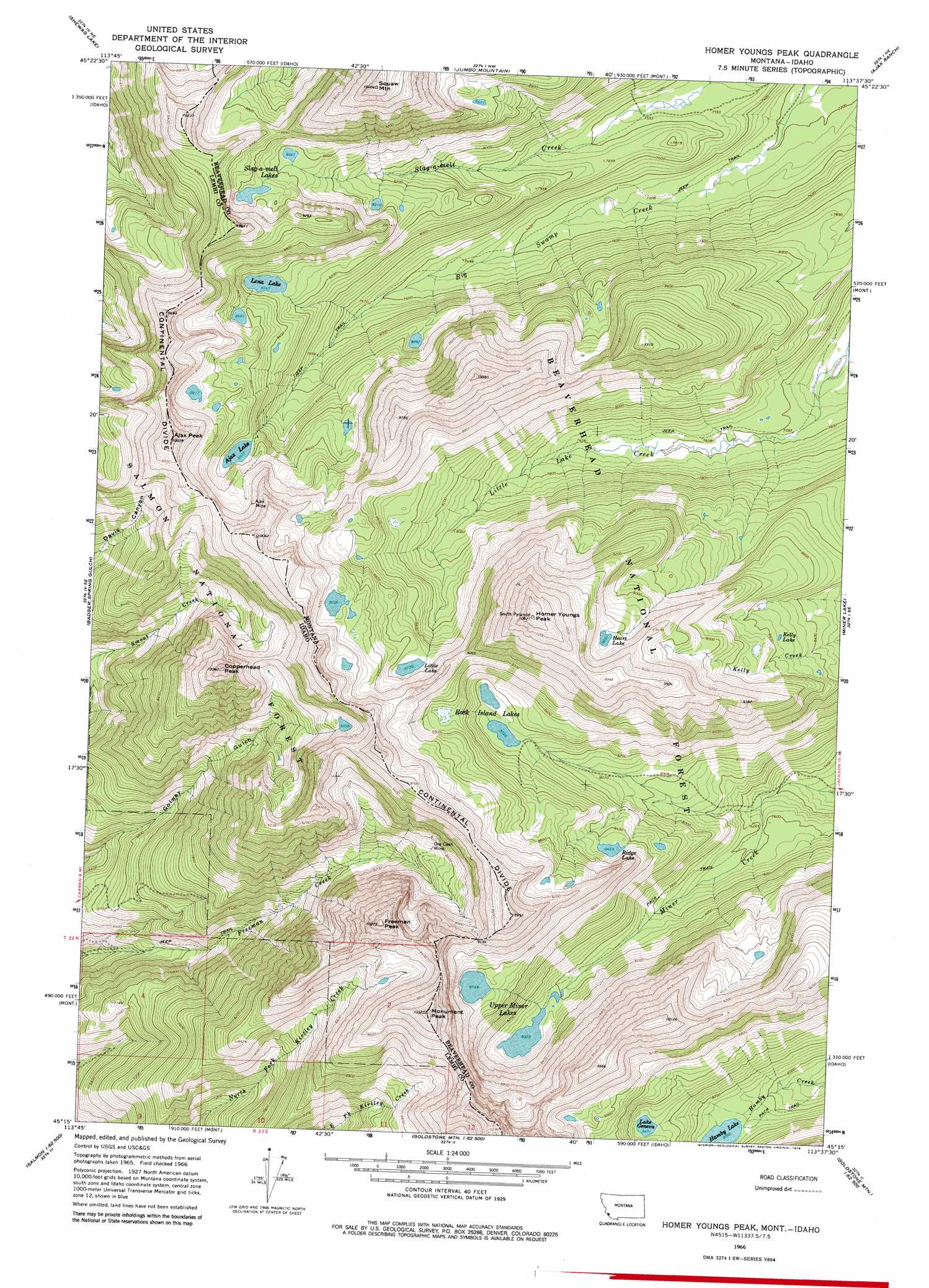
USGS Topo Quad 45113c6 - 1:24,000 scale
| Topo Map Name: | Homer Youngs Peak |
| USGS Topo Quad ID: | 45113c6 |
| Print Size: | ca. 21 1/4" wide x 27" high |
| Southeast Coordinates: | 45.25° N latitude / 113.625° W longitude |
| Map Center Coordinates: | 45.3125° N latitude / 113.6875° W longitude |
| U.S. States: | MT, ID |
| Filename: | o45113c6.jpg |
| Download Map JPG Image: | Homer Youngs Peak topo map 1:24,000 scale |
| Map Type: | Topographic |
| Topo Series: | 7.5´ |
| Map Scale: | 1:24,000 |
| Source of Map Images: | United States Geological Survey (USGS) |
| Alternate Map Versions: |
Homer Youngs Peak MT 1966, updated 1971 Download PDF Buy paper map Homer Youngs Peak MT 1966, updated 1979 Download PDF Buy paper map Homer Youngs Peak MT 1966, updated 1979 Download PDF Buy paper map Homer Youngs Peak MT 1997, updated 2002 Download PDF Buy paper map Homer Youngs Peak MT 2011 Download PDF Buy paper map Homer Youngs Peak MT 2014 Download PDF Buy paper map |
| FStopo: | US Forest Service topo Homer Youngs Peak is available: Download FStopo PDF Download FStopo TIF |
1:24,000 Topo Quads surrounding Homer Youngs Peak
Gibbonsville |
Big Hole Pass |
Isaac Meadows |
Highland Ranch |
Wisdom |
North Fork |
Shewag Lake |
Jumbo Mountain |
Ajax Ranch |
Fox Gulch |
Bird Creek |
Badger Spring Gulch |
Homer Youngs Peak |
Miner Lake |
Jackson |
Salmon |
East Of Salmon |
Bohannon Spring |
Goldstone Pass |
Selway Mountain |
Williams Lake |
Sal Mountain |
Baker |
Goldstone Mountain |
Kitty Creek |
> Back to 45113a1 at 1:100,000 scale
> Back to 45112a1 at 1:250,000 scale
> Back to U.S. Topo Maps home
Homer Youngs Peak topo map: Gazetteer
Homer Youngs Peak: Lakes
Ajax Lake elevation 2599m 8526′Albino Lake elevation 2689m 8822′
Hamby Lake elevation 2468m 8097′
Heart Lake elevation 2815m 9235′
Hidden Lake elevation 2468m 8097′
Kelly Lake elevation 2604m 8543′
Lake Geneva elevation 2577m 8454′
Lena Lake elevation 2545m 8349′
Little Lake elevation 2662m 8733′
Ridge Lake elevation 2577m 8454′
Rock Island Lakes elevation 2541m 8336′
Slag-a-melt Lakes elevation 2613m 8572′
Upper Miner Lakes elevation 2449m 8034′
Homer Youngs Peak: Mines
Ajax Mine elevation 2757m 9045′Jackson/Miner Creek Mine elevation 2666m 8746′
Ore Cash Mine elevation 2628m 8622′
Slag-A-Melt Mine elevation 2396m 7860′
Slag-a-Melt Mine elevation 2434m 7985′
Homer Youngs Peak: Summits
Ajax Peak elevation 3028m 9934′Copperhead Peak elevation 3065m 10055′
Freeman Peak elevation 3132m 10275′
Hirschy Mountain elevation 3134m 10282′
Homer Youngs Peak elevation 3234m 10610′
Monument Peak elevation 3134m 10282′
Monument Peak elevation 3134m 10282′
Sacajawea Peaks elevation 3154m 10347′
Homer Youngs Peak digital topo map on disk
Buy this Homer Youngs Peak topo map showing relief, roads, GPS coordinates and other geographical features, as a high-resolution digital map file on DVD: