Bird Creek Topo Map Idaho
To zoom in, hover over the map of Bird Creek
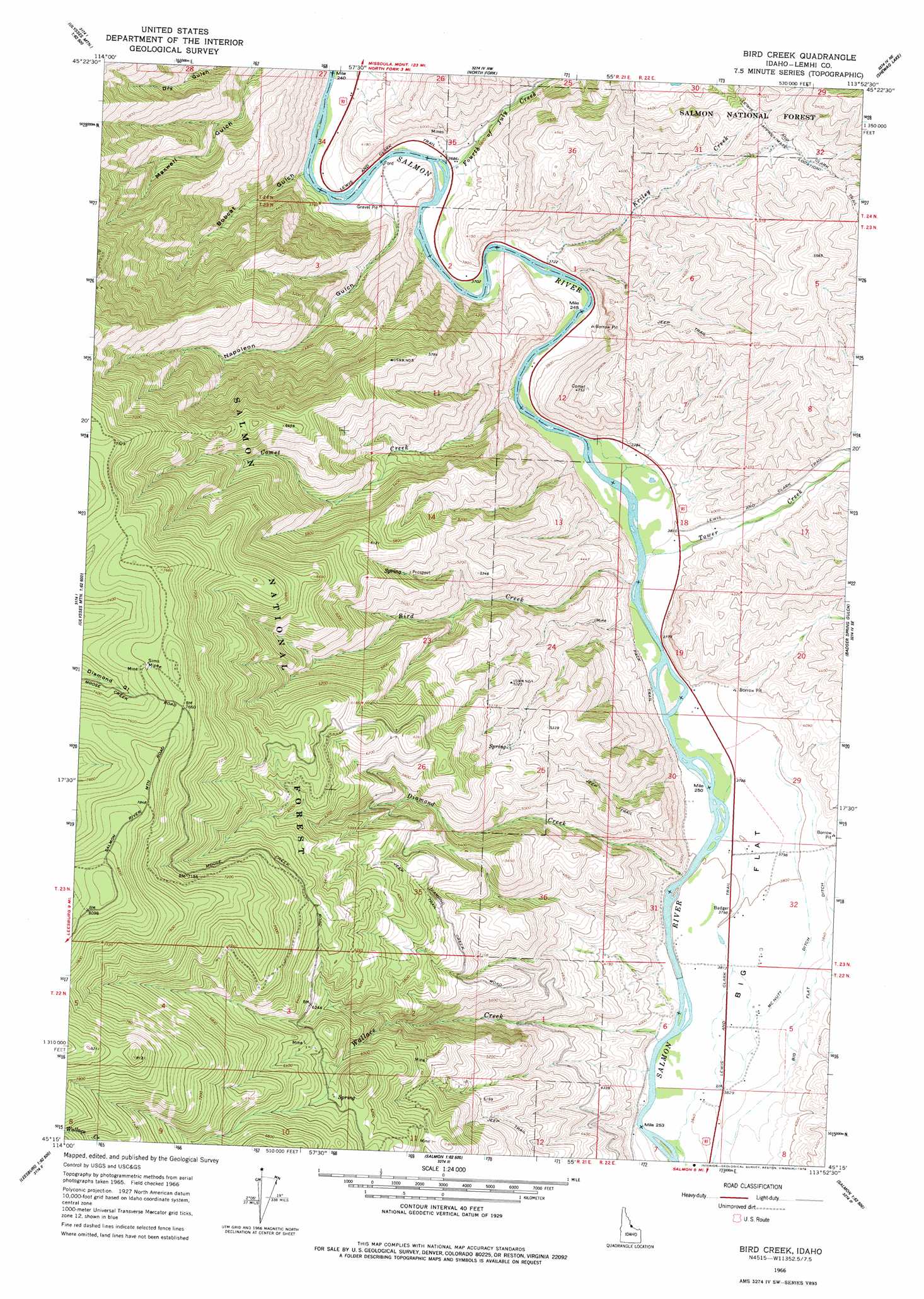
USGS Topo Quad 45113c8 - 1:24,000 scale
| Topo Map Name: | Bird Creek |
| USGS Topo Quad ID: | 45113c8 |
| Print Size: | ca. 21 1/4" wide x 27" high |
| Southeast Coordinates: | 45.25° N latitude / 113.875° W longitude |
| Map Center Coordinates: | 45.3125° N latitude / 113.9375° W longitude |
| U.S. State: | ID |
| Filename: | o45113c8.jpg |
| Download Map JPG Image: | Bird Creek topo map 1:24,000 scale |
| Map Type: | Topographic |
| Topo Series: | 7.5´ |
| Map Scale: | 1:24,000 |
| Source of Map Images: | United States Geological Survey (USGS) |
| Alternate Map Versions: |
Bird Creek ID 1966, updated 1971 Download PDF Buy paper map Bird Creek ID 1966, updated 1978 Download PDF Buy paper map Bird Creek ID 2011 Download PDF Buy paper map Bird Creek ID 2013 Download PDF Buy paper map |
| FStopo: | US Forest Service topo Bird Creek is available: Download FStopo PDF Download FStopo TIF |
1:24,000 Topo Quads surrounding Bird Creek
Henderson Ridge |
Allan Mountain |
Gibbonsville |
Big Hole Pass |
Isaac Meadows |
Ulysses |
Ulysses Mountain |
North Fork |
Shewag Lake |
Jumbo Mountain |
Pine Creek Ridge |
Napoleon Hill |
Bird Creek |
Badger Spring Gulch |
Homer Youngs Peak |
Jureano Mountain |
Leesburg |
Salmon |
East Of Salmon |
Bohannon Spring |
Cobalt |
Lake Mountain |
Williams Lake |
Sal Mountain |
Baker |
> Back to 45113a1 at 1:100,000 scale
> Back to 45112a1 at 1:250,000 scale
> Back to U.S. Topo Maps home
Bird Creek topo map: Gazetteer
Bird Creek: Canals
Big Flat Ditch elevation 1181m 3874′McNutt Ditch elevation 1170m 3838′
Bird Creek: Flats
Big Flat elevation 1162m 3812′Bird Creek: Mines
Sims Mine elevation 2319m 7608′Bird Creek: Streams
Bird Creek elevation 1144m 3753′Comet Creek elevation 1141m 3743′
Diamond Creek elevation 1156m 3792′
East Fork Tower Creek elevation 1244m 4081′
Fourth of July Creek elevation 1120m 3674′
Kriley Creek elevation 1136m 3727′
Tower Creek elevation 1147m 3763′
Wallace Creek elevation 1170m 3838′
Bird Creek: Valleys
Bobcat Gulch elevation 1119m 3671′Napoleon Gulch elevation 1157m 3795′
Bird Creek digital topo map on disk
Buy this Bird Creek topo map showing relief, roads, GPS coordinates and other geographical features, as a high-resolution digital map file on DVD: