Wisdom Topo Map Montana
To zoom in, hover over the map of Wisdom
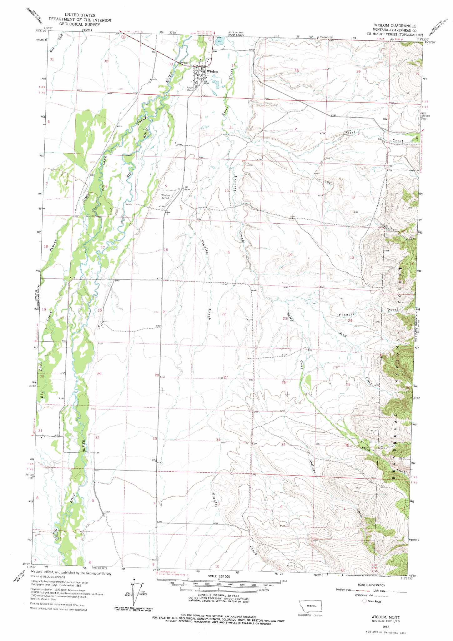
USGS Topo Quad 45113e4 - 1:24,000 scale
| Topo Map Name: | Wisdom |
| USGS Topo Quad ID: | 45113e4 |
| Print Size: | ca. 21 1/4" wide x 27" high |
| Southeast Coordinates: | 45.5° N latitude / 113.375° W longitude |
| Map Center Coordinates: | 45.5625° N latitude / 113.4375° W longitude |
| U.S. State: | MT |
| Filename: | o45113e4.jpg |
| Download Map JPG Image: | Wisdom topo map 1:24,000 scale |
| Map Type: | Topographic |
| Topo Series: | 7.5´ |
| Map Scale: | 1:24,000 |
| Source of Map Images: | United States Geological Survey (USGS) |
| Alternate Map Versions: |
Wisdom MT 1962, updated 1964 Download PDF Buy paper map Wisdom MT 1962, updated 1978 Download PDF Buy paper map Wisdom MT 1997, updated 2002 Download PDF Buy paper map Wisdom MT 2011 Download PDF Buy paper map Wisdom MT 2014 Download PDF Buy paper map |
| FStopo: | US Forest Service topo Wisdom is available: Download FStopo PDF Download FStopo TIF |
1:24,000 Topo Quads surrounding Wisdom
Bender Point |
Mussigbrod Lake |
Pintlar Lake |
Pine Hill |
Foolhen Mountain |
Big Hole Battlefield |
Gibbons School |
Mud Lake |
Proposal Rock |
Shaw Mountain |
Isaac Meadows |
Highland Ranch |
Wisdom |
Stewart Mountain |
Odell Lake |
Jumbo Mountain |
Ajax Ranch |
Fox Gulch |
Jackson Hill |
Maverick Mountain |
Homer Youngs Peak |
Miner Lake |
Jackson |
Butch Hill |
Tash Peak |
> Back to 45113e1 at 1:100,000 scale
> Back to 45112a1 at 1:250,000 scale
> Back to U.S. Topo Maps home
Wisdom topo map: Gazetteer
Wisdom: Airports
Wisdom Airport elevation 1867m 6125′Wisdom: Dams
Dry Fields Dam elevation 1863m 6112′Wisdom: Mines
Clara Mine elevation 1965m 6446′Clara Mine elevation 1971m 6466′
Wisdom: Parks
American Legion Park elevation 1844m 6049′Wisdom: Populated Places
Wisdom elevation 1844m 6049′Wisdom: Post Offices
Wisdom Post Office elevation 1844m 6049′Wisdom: Streams
Big Lake Creek elevation 1864m 6115′Francis Creek elevation 1848m 6062′
Hooligan Creek elevation 1885m 6184′
Rock Creek elevation 1848m 6062′
Sand Creek elevation 1870m 6135′
Sheep Creek elevation 1870m 6135′
Stanley Creek elevation 1849m 6066′
Wisdom: Valleys
Dry Gulch elevation 1848m 6062′Wisdom: Wells
02S15W32AABB01 Well elevation 1848m 6062′02S15W32ABAB01 Well elevation 1848m 6062′
02S15W33BDDA01 Well elevation 1844m 6049′
02S15W33CCAB01 Well elevation 1849m 6066′
02S15W33DDBD01 Well elevation 1847m 6059′
02S15W34BACC01 Well elevation 1843m 6046′
02S15W34BCCD01 Well elevation 1844m 6049′
02S15W34CBBB01 Well elevation 1844m 6049′
02S15W34CBBC01 Well elevation 1845m 6053′
02S15W34CCCB01 Well elevation 1848m 6062′
03S15W04ADCD01 Well elevation 1849m 6066′
03S15W08CCCA01 Well elevation 1862m 6108′
03S15W16DCCD01 Well elevation 1873m 6145′
03S15W20DBCC01 Well elevation 1876m 6154′
03S15W20DBCC02 Well elevation 1876m 6154′
03S15W21DCAB01 Well elevation 1876m 6154′
03S15W31DBAB01 Well elevation 1882m 6174′
04S15W02CCCB01 Well elevation 1936m 6351′
04S15W05BADA01 Well elevation 1888m 6194′
04S15W05DBCD01 Well elevation 1891m 6204′
04S15W11BBBB01 Well elevation 1936m 6351′
Wisdom digital topo map on disk
Buy this Wisdom topo map showing relief, roads, GPS coordinates and other geographical features, as a high-resolution digital map file on DVD: