Isaac Meadows Topo Map Montana
To zoom in, hover over the map of Isaac Meadows
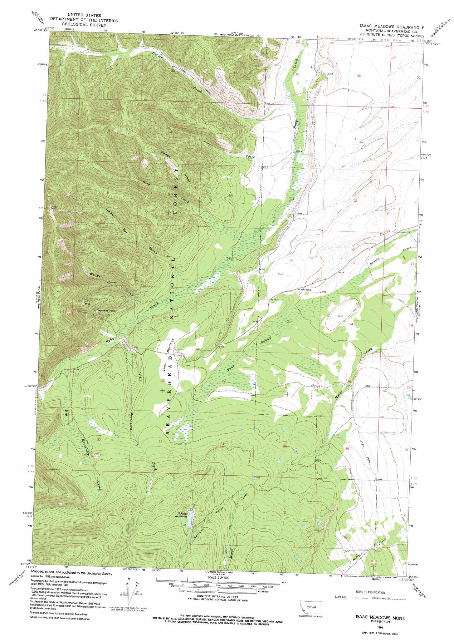
USGS Topo Quad 45113e6 - 1:24,000 scale
| Topo Map Name: | Isaac Meadows |
| USGS Topo Quad ID: | 45113e6 |
| Print Size: | ca. 21 1/4" wide x 27" high |
| Southeast Coordinates: | 45.5° N latitude / 113.625° W longitude |
| Map Center Coordinates: | 45.5625° N latitude / 113.6875° W longitude |
| U.S. State: | MT |
| Filename: | o45113e6.jpg |
| Download Map JPG Image: | Isaac Meadows topo map 1:24,000 scale |
| Map Type: | Topographic |
| Topo Series: | 7.5´ |
| Map Scale: | 1:24,000 |
| Source of Map Images: | United States Geological Survey (USGS) |
| Alternate Map Versions: |
Isaac Meadows MT 1966, updated 1970 Download PDF Buy paper map Isaac Meadows MT 1966, updated 1990 Download PDF Buy paper map Isaac Meadows MT 1997, updated 2002 Download PDF Buy paper map Isaac Meadows MT 2011 Download PDF Buy paper map Isaac Meadows MT 2014 Download PDF Buy paper map |
| FStopo: | US Forest Service topo Isaac Meadows is available: Download FStopo PDF Download FStopo TIF |
1:24,000 Topo Quads surrounding Isaac Meadows
Sula |
Schultz Saddle |
Bender Point |
Mussigbrod Lake |
Pintlar Lake |
Lost Trail Pass |
Elk Creek |
Big Hole Battlefield |
Gibbons School |
Mud Lake |
Gibbonsville |
Big Hole Pass |
Isaac Meadows |
Highland Ranch |
Wisdom |
North Fork |
Shewag Lake |
Jumbo Mountain |
Ajax Ranch |
Fox Gulch |
Bird Creek |
Badger Spring Gulch |
Homer Youngs Peak |
Miner Lake |
Jackson |
> Back to 45113e1 at 1:100,000 scale
> Back to 45112a1 at 1:250,000 scale
> Back to U.S. Topo Maps home
Isaac Meadows topo map: Gazetteer
Isaac Meadows: Dams
Schultz Dam elevation 2213m 7260′Isaac Meadows: Flats
Isaac Meadows elevation 2050m 6725′Isaac Meadows: Mines
Moose Horn Mine elevation 2072m 6797′Moosehorn Mine elevation 2098m 6883′
Isaac Meadows: Populated Places
Moosehorn (historical) elevation 2044m 6706′Isaac Meadows: Reservoirs
Schultz Reservoir elevation 2213m 7260′Isaac Meadows: Ridges
Badger Ridge elevation 2260m 7414′Isaac Meadows: Streams
Big Moosehorn Creek elevation 2005m 6578′Butler Creek elevation 1909m 6263′
Gory Creek elevation 1946m 6384′
Holland Creek elevation 2125m 6971′
Little Moosehorn Creek elevation 1988m 6522′
Sawpit Creek elevation 1927m 6322′
Isaac Meadows: Swamps
Yank Swamp elevation 2011m 6597′Isaac Meadows: Valleys
Nickel Bar Gulch elevation 1975m 6479′Portal Gulch elevation 1993m 6538′
Wenger Gulch elevation 1982m 6502′
Isaac Meadows digital topo map on disk
Buy this Isaac Meadows topo map showing relief, roads, GPS coordinates and other geographical features, as a high-resolution digital map file on DVD: