Shaw Mountain Topo Map Montana
To zoom in, hover over the map of Shaw Mountain
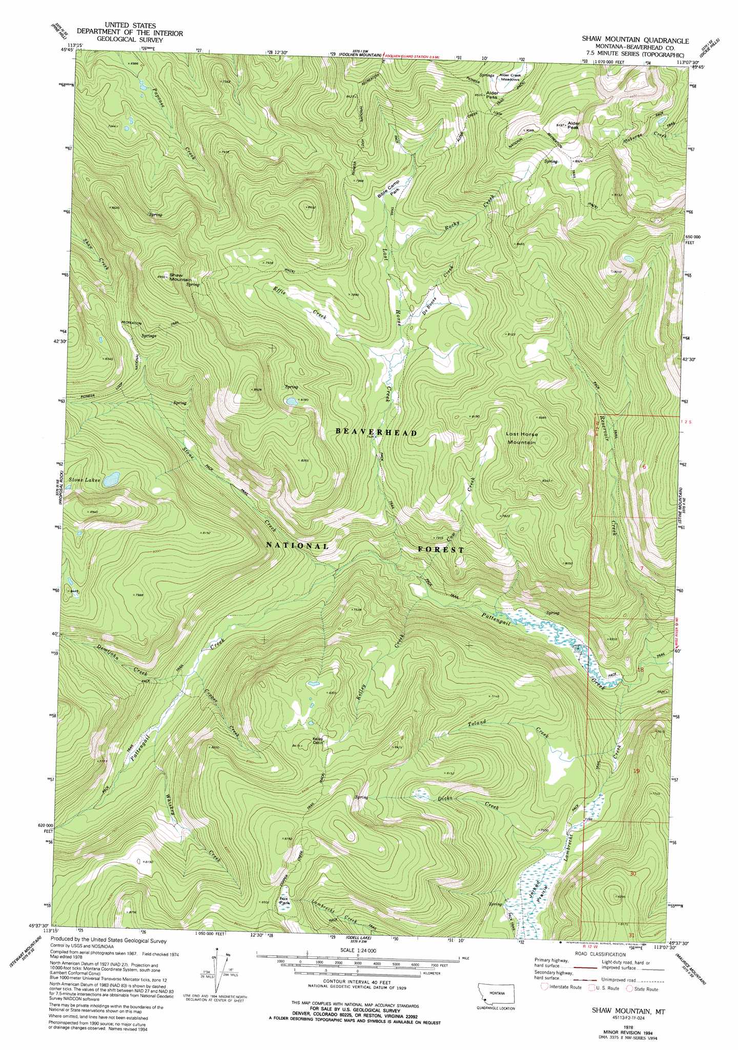
USGS Topo Quad 45113f2 - 1:24,000 scale
| Topo Map Name: | Shaw Mountain |
| USGS Topo Quad ID: | 45113f2 |
| Print Size: | ca. 21 1/4" wide x 27" high |
| Southeast Coordinates: | 45.625° N latitude / 113.125° W longitude |
| Map Center Coordinates: | 45.6875° N latitude / 113.1875° W longitude |
| U.S. State: | MT |
| Filename: | o45113f2.jpg |
| Download Map JPG Image: | Shaw Mountain topo map 1:24,000 scale |
| Map Type: | Topographic |
| Topo Series: | 7.5´ |
| Map Scale: | 1:24,000 |
| Source of Map Images: | United States Geological Survey (USGS) |
| Alternate Map Versions: |
Shaw Mountain MT 1978, updated 1994 Download PDF Buy paper map Shaw Mountain MT 1997, updated 2002 Download PDF Buy paper map Shaw Mountain MT 2011 Download PDF Buy paper map Shaw Mountain MT 2014 Download PDF Buy paper map |
| FStopo: | US Forest Service topo Shaw Mountain is available: Download FStopo PDF Download FStopo TIF |
1:24,000 Topo Quads surrounding Shaw Mountain
Warren Peak |
Long Peak |
Lower Seymour Lake |
Lincoln Gulch |
Dickie Peak |
Pintlar Lake |
Pine Hill |
Foolhen Mountain |
Dickie Hills |
Wise River |
Mud Lake |
Proposal Rock |
Shaw Mountain |
Stine Mountain |
Vipond Park |
Wisdom |
Stewart Mountain |
Odell Lake |
Maurice Mountain |
Mount Tahepia |
Fox Gulch |
Jackson Hill |
Maverick Mountain |
Elkhorn Hot Springs |
Torrey Mountain |
> Back to 45113e1 at 1:100,000 scale
> Back to 45112a1 at 1:250,000 scale
> Back to U.S. Topo Maps home
Shaw Mountain topo map: Gazetteer
Shaw Mountain: Flats
Alder Creek Meadows elevation 2559m 8395′Bible Camp Park elevation 2359m 7739′
Fox Park elevation 2557m 8389′
Jerked Prairie elevation 2202m 7224′
Shaw Mountain: Gaps
Alder Pass elevation 2604m 8543′Shaw Mountain: Lakes
Stone Lakes elevation 2584m 8477′Shaw Mountain: Streams
Copper Creek elevation 2143m 7030′Cow Creek elevation 2013m 6604′
De Boose Creek elevation 2305m 7562′
Demijohn Creek elevation 2145m 7037′
Dicks Creek elevation 2203m 7227′
Effie Creek elevation 2291m 7516′
Kelley Creek elevation 2007m 6584′
Lost Horse Creek elevation 2033m 6669′
Reservoir Creek elevation 1937m 6354′
Rocky Creek elevation 2328m 7637′
Stone Creek elevation 2071m 6794′
Toland Creek elevation 2081m 6827′
Whiskey Creek elevation 2153m 7063′
Shaw Mountain: Summits
Alder Peak elevation 2798m 9179′Lost Horse Mountain elevation 2599m 8526′
Shaw Mountain elevation 2724m 8937′
Shaw Mountain: Trails
Alder Creek Trail elevation 2518m 8261′Copper Creek Trail elevation 2501m 8205′
Hiline Trail elevation 2550m 8366′
Shaw Mountain digital topo map on disk
Buy this Shaw Mountain topo map showing relief, roads, GPS coordinates and other geographical features, as a high-resolution digital map file on DVD: