Proposal Rock Topo Map Montana
To zoom in, hover over the map of Proposal Rock
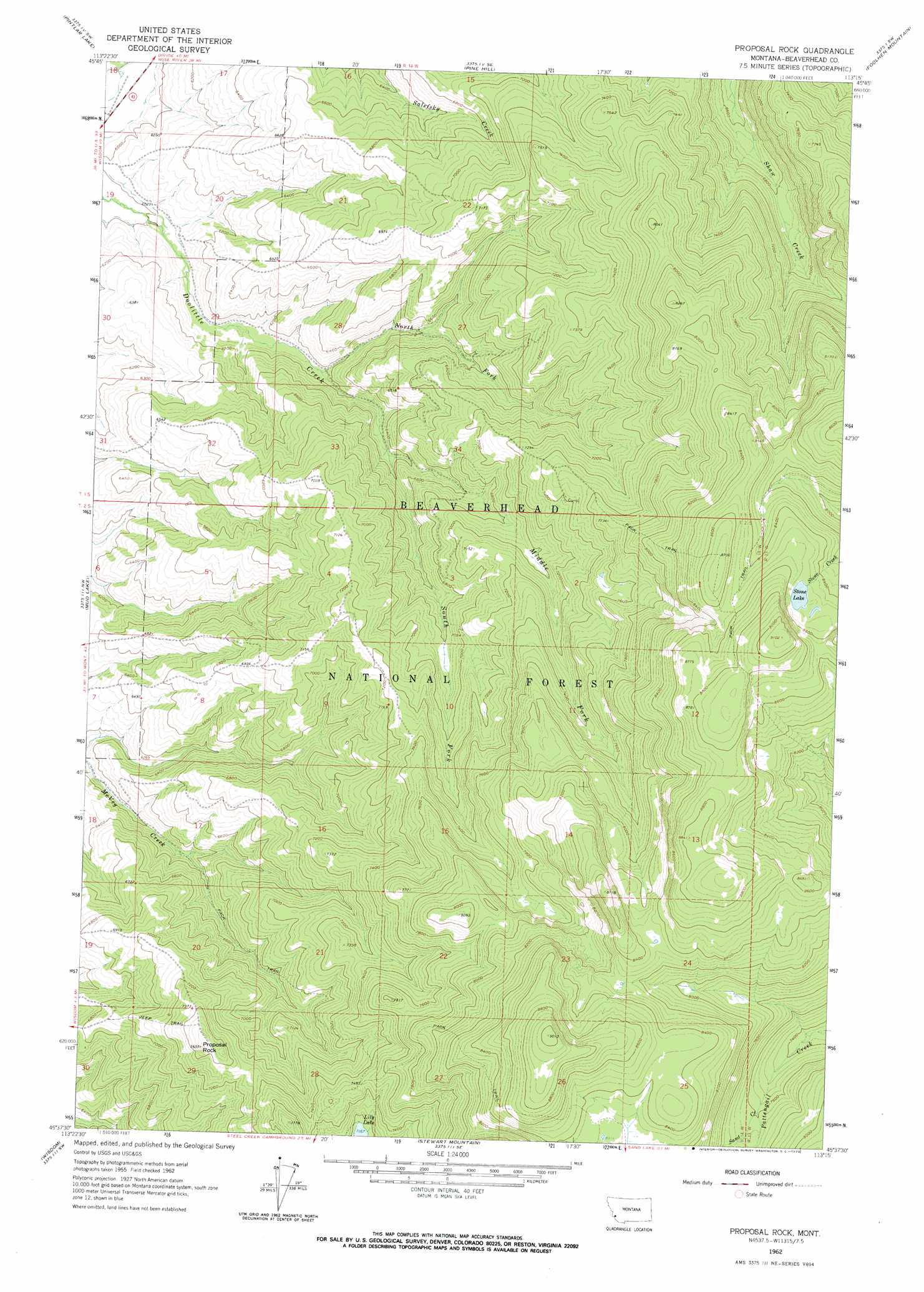
USGS Topo Quad 45113f3 - 1:24,000 scale
| Topo Map Name: | Proposal Rock |
| USGS Topo Quad ID: | 45113f3 |
| Print Size: | ca. 21 1/4" wide x 27" high |
| Southeast Coordinates: | 45.625° N latitude / 113.25° W longitude |
| Map Center Coordinates: | 45.6875° N latitude / 113.3125° W longitude |
| U.S. State: | MT |
| Filename: | o45113f3.jpg |
| Download Map JPG Image: | Proposal Rock topo map 1:24,000 scale |
| Map Type: | Topographic |
| Topo Series: | 7.5´ |
| Map Scale: | 1:24,000 |
| Source of Map Images: | United States Geological Survey (USGS) |
| Alternate Map Versions: |
Proposal Rock MT 1962, updated 1964 Download PDF Buy paper map Proposal Rock MT 1962, updated 1973 Download PDF Buy paper map Proposal Rock MT 1997, updated 2002 Download PDF Buy paper map Proposal Rock MT 2011 Download PDF Buy paper map Proposal Rock MT 2014 Download PDF Buy paper map |
| FStopo: | US Forest Service topo Proposal Rock is available: Download FStopo PDF Download FStopo TIF |
1:24,000 Topo Quads surrounding Proposal Rock
Kelly Lake |
Warren Peak |
Long Peak |
Lower Seymour Lake |
Lincoln Gulch |
Mussigbrod Lake |
Pintlar Lake |
Pine Hill |
Foolhen Mountain |
Dickie Hills |
Gibbons School |
Mud Lake |
Proposal Rock |
Shaw Mountain |
Stine Mountain |
Highland Ranch |
Wisdom |
Stewart Mountain |
Odell Lake |
Maurice Mountain |
Ajax Ranch |
Fox Gulch |
Jackson Hill |
Maverick Mountain |
Elkhorn Hot Springs |
> Back to 45113e1 at 1:100,000 scale
> Back to 45112a1 at 1:250,000 scale
> Back to U.S. Topo Maps home
Proposal Rock topo map: Gazetteer
Proposal Rock: Pillars
Proposal Rock elevation 2316m 7598′Proposal Rock: Springs
01S14W16CBAD01 Spring elevation 2008m 6587′01S14W22CABA01 Spring elevation 2136m 7007′
01S14W22CCDD01 Spring elevation 2114m 6935′
01S14W28ABAB01 Spring elevation 2047m 6715′
Proposal Rock: Streams
Middle Fork Doolittle Creek elevation 1932m 6338′North Fork Doolittle Fork Creek elevation 1873m 6145′
Sand Creek elevation 2318m 7604′
South Fork Doolittle Creek elevation 1932m 6338′
Proposal Rock: Wells
01S14W18DBAC01 Well elevation 1816m 5958′01S14W20AAAB01 Well elevation 1964m 6443′
Proposal Rock digital topo map on disk
Buy this Proposal Rock topo map showing relief, roads, GPS coordinates and other geographical features, as a high-resolution digital map file on DVD: