Lost Trail Pass Topo Map Montana
To zoom in, hover over the map of Lost Trail Pass
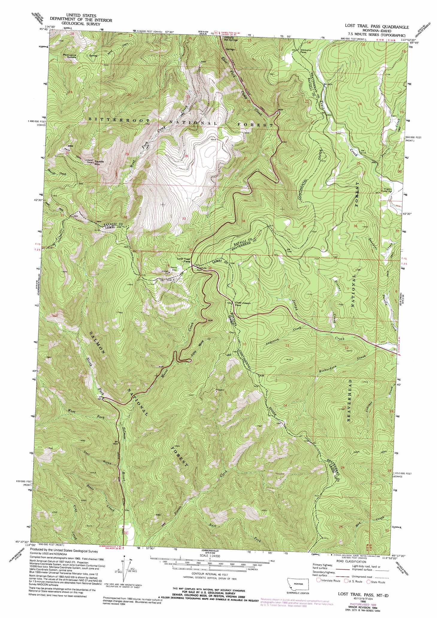
USGS Topo Quad 45113f8 - 1:24,000 scale
| Topo Map Name: | Lost Trail Pass |
| USGS Topo Quad ID: | 45113f8 |
| Print Size: | ca. 21 1/4" wide x 27" high |
| Southeast Coordinates: | 45.625° N latitude / 113.875° W longitude |
| Map Center Coordinates: | 45.6875° N latitude / 113.9375° W longitude |
| U.S. States: | MT, ID |
| Filename: | o45113f8.jpg |
| Download Map JPG Image: | Lost Trail Pass topo map 1:24,000 scale |
| Map Type: | Topographic |
| Topo Series: | 7.5´ |
| Map Scale: | 1:24,000 |
| Source of Map Images: | United States Geological Survey (USGS) |
| Alternate Map Versions: |
Lost Trail Pass MT 1966, updated 1970 Download PDF Buy paper map Lost Trail Pass MT 1966, updated 1989 Download PDF Buy paper map Lost Trail Pass MT 1966, updated 1994 Download PDF Buy paper map Lost Trail Pass MT 1997, updated 2002 Download PDF Buy paper map Lost Trail Pass MT 2011 Download PDF Buy paper map Lost Trail Pass MT 2014 Download PDF Buy paper map |
| FStopo: | US Forest Service topo Lost Trail Pass is available: Download FStopo PDF Download FStopo TIF |
1:24,000 Topo Quads surrounding Lost Trail Pass
Burnt Ridge |
Robbins Gulch |
French Basin |
Jennings Camp Creek |
Lick Creek |
Piquett Creek |
Medicine Hot Springs |
Sula |
Schultz Saddle |
Bender Point |
Piquett Mountain |
Overwhich Falls |
Lost Trail Pass |
Elk Creek |
Big Hole Battlefield |
Henderson Ridge |
Allan Mountain |
Gibbonsville |
Big Hole Pass |
Isaac Meadows |
Ulysses |
Ulysses Mountain |
North Fork |
Shewag Lake |
Jumbo Mountain |
> Back to 45113e1 at 1:100,000 scale
> Back to 45112a1 at 1:250,000 scale
> Back to U.S. Topo Maps home
Lost Trail Pass topo map: Gazetteer
Lost Trail Pass: Gaps
Chief Joseph Pass elevation 2210m 7250′Gibbons Pass elevation 2117m 6945′
Lost Trail Pass elevation 2140m 7020′
Porcupine Saddle elevation 2182m 7158′
Lost Trail Pass: Ridges
Lewis and Clark Ridge elevation 2495m 8185′Lost Trail Pass: Springs
Gallogly Spring elevation 1632m 5354′Lost Trail Pass: Streams
Anderson Creek elevation 2058m 6751′East Fork Pierce Creek elevation 1649m 5410′
Little Moose Creek elevation 1880m 6167′
Moose Creek elevation 1709m 5606′
Prairie Creek elevation 2024m 6640′
Richardson Creek elevation 1999m 6558′
Scooter Creek elevation 2035m 6676′
State Creek elevation 1626m 5334′
West Fork North Fork Salmon River elevation 1707m 5600′
Lost Trail Pass: Summits
Saddle Mountain elevation 2572m 8438′Lost Trail Pass: Trails
B-2 Ski Trail elevation 2150m 7053′Big Hole National Recreation Trail elevation 1957m 6420′
Chicken Out Ski Trail elevation 2150m 7053′
Drifter Ski Trail elevation 2150m 7053′
Far Out Ski Trail elevation 2150m 7053′
Hideout Ski Trail elevation 2150m 7053′
Lightning Ski Trail elevation 2150m 7053′
Meadow Run Ski Trail elevation 2150m 7053′
Meadow Trail Ski Trail elevation 2150m 7053′
North Bowl Ski Trail elevation 2150m 7053′
North Face Ski Trail elevation 2150m 7053′
Powder Bowl Ski Trail elevation 2150m 7053′
Salmon Ski Trail elevation 2150m 7053′
South Face Ski Trail elevation 2150m 7053′
Southern Comfort Ski Trail elevation 2150m 7053′
Speedway Ski Trail elevation 2150m 7053′
Thunder Ski Trail elevation 2150m 7053′
Upper Far Out Ski Trail elevation 2150m 7053′
West Meadow Ski Trail elevation 2150m 7053′
Lost Trail Pass: Valleys
Cool Gulch elevation 1682m 5518′Lost Trail Pass digital topo map on disk
Buy this Lost Trail Pass topo map showing relief, roads, GPS coordinates and other geographical features, as a high-resolution digital map file on DVD: