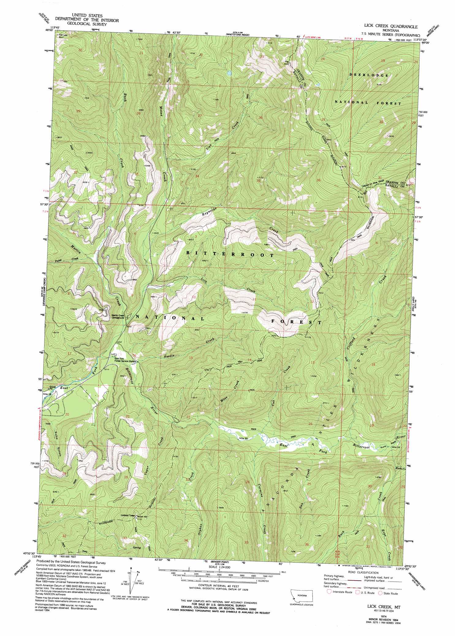
Lick Creek Topo Map Montana
To zoom in, hover over the map of Lick Creek
USGS Topo Quad 45113h6 - 1:24,000 scale
| Topo Map Name: | Lick Creek |
| USGS Topo Quad ID: | 45113h6 |
| Print Size: | ca. 21 1/4" wide x 27" high |
| Southeast Coordinates: | 45.875° N latitude / 113.625° W longitude |
| Map Center Coordinates: | 45.9375° N latitude / 113.6875° W longitude |
| U.S. State: | MT |
| Filename: | o45113h6.jpg |
| Download Map JPG Image: | Lick Creek topo map 1:24,000 scale |
| Map Type: | Topographic |
| Topo Series: | 7.5´ |
| Map Scale: | 1:24,000 |
| Source of Map Images: | United States Geological Survey (USGS) |
| Alternate Map Versions: |
Lick Creek MT 1974, updated 1977 Download PDF Buy paper map Lick Creek MT 1974, updated 1994 Download PDF Buy paper map Lick Creek MT 1998, updated 2002 Download PDF Buy paper map Lick Creek MT 2011 Download PDF Buy paper map Lick Creek MT 2014 Download PDF Buy paper map |
| FStopo: | US Forest Service topo Lick Creek is available: Download FStopo PDF Download FStopo TIF |
1:24,000 Topo Quads surrounding Lick Creek
Gird Point |
Skalkaho Pass |
Mount Emerine |
Maukey Gulch |
Potato Lakes |
Bald Top Mountain |
Kent Peak |
Whetstone Ridge |
Moose Lake |
Carpp Ridge |
French Basin |
Jennings Camp Creek |
Lick Creek |
Kelly Lake |
Warren Peak |
Sula |
Schultz Saddle |
Bender Point |
Mussigbrod Lake |
Pintlar Lake |
Lost Trail Pass |
Elk Creek |
Big Hole Battlefield |
Gibbons School |
Mud Lake |
> Back to 45113e1 at 1:100,000 scale
> Back to 45112a1 at 1:250,000 scale
> Back to U.S. Topo Maps home
Lick Creek topo map: Gazetteer
Lick Creek: Basins
Hole in the Wall elevation 2362m 7749′Lick Creek: Flats
Kurtz Flats elevation 1704m 5590′Lick Creek: Gaps
Lick Creek Saddle elevation 2059m 6755′Lick Creek: Parks
Billie Springer Memorial Park elevation 1593m 5226′Lick Creek: Streams
Buck Creek elevation 1704m 5590′Bush Creek elevation 1643m 5390′
Carmine Creek elevation 1663m 5456′
Clifford Creek elevation 1692m 5551′
Cub Creek elevation 1665m 5462′
Hope Creek elevation 1909m 6263′
Kurtz Creek elevation 1801m 5908′
Lick Creek elevation 1627m 5337′
Martin Creek elevation 1584m 5196′
Moose Creek elevation 1650m 5413′
Moss Creek elevation 1651m 5416′
Needle Creek elevation 1600m 5249′
Orphan Creek elevation 1647m 5403′
Paint Creek elevation 1646m 5400′
Reynolds Creek elevation 1650m 5413′
Sign Creek elevation 1717m 5633′
Sun Creek elevation 1671m 5482′
Vapor Creek elevation 1630m 5347′
Lick Creek: Valleys
Echo Gulch elevation 1560m 5118′Lick Creek digital topo map on disk
Buy this Lick Creek topo map showing relief, roads, GPS coordinates and other geographical features, as a high-resolution digital map file on DVD: