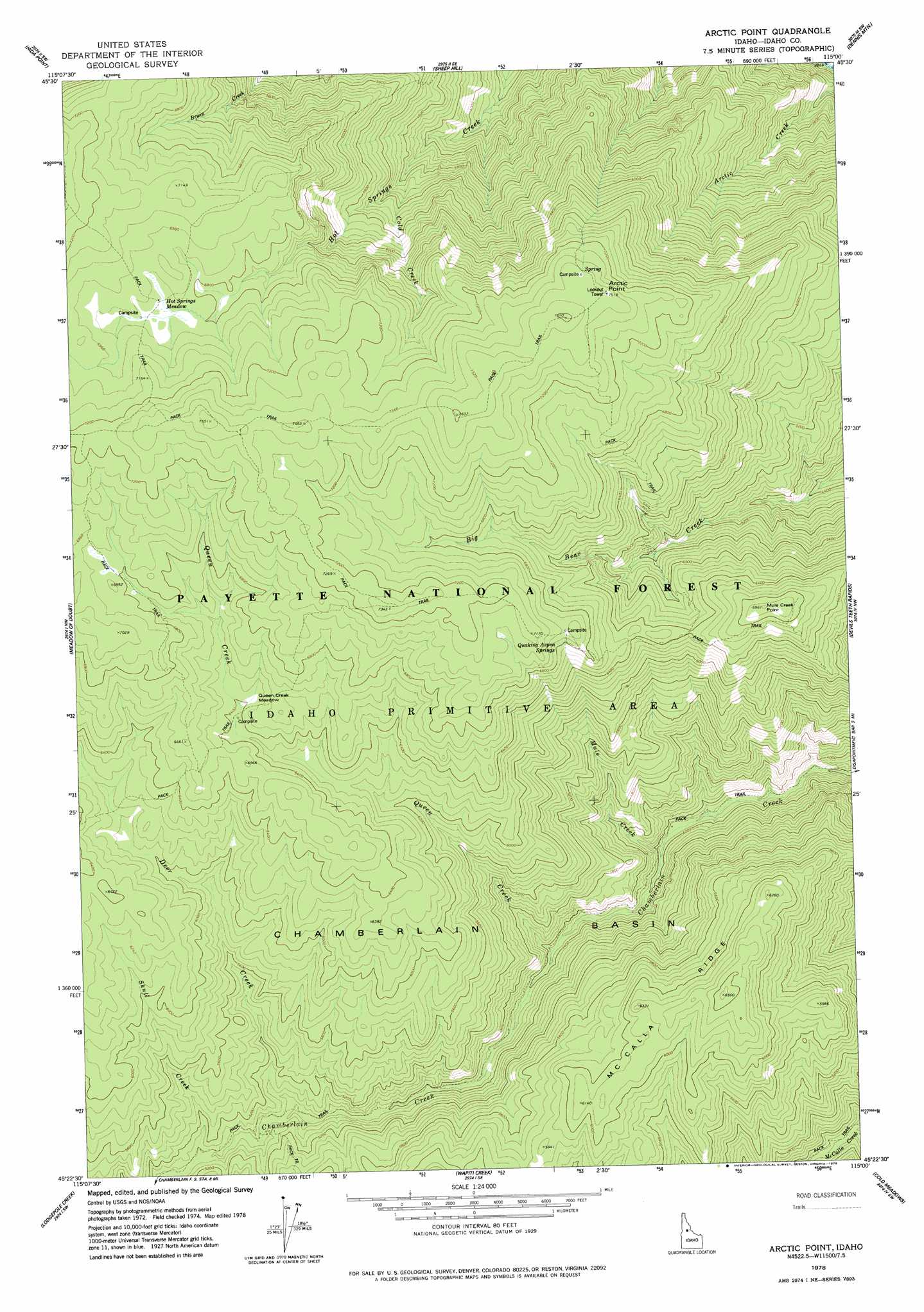
Arctic Point Topo Map Idaho
To zoom in, hover over the map of Arctic Point
USGS Topo Quad 45115d1 - 1:24,000 scale
| Topo Map Name: | Arctic Point |
| USGS Topo Quad ID: | 45115d1 |
| Print Size: | ca. 21 1/4" wide x 27" high |
| Southeast Coordinates: | 45.375° N latitude / 115° W longitude |
| Map Center Coordinates: | 45.4375° N latitude / 115.0625° W longitude |
| U.S. State: | ID |
| Filename: | o45115d1.jpg |
| Download Map JPG Image: | Arctic Point topo map 1:24,000 scale |
| Map Type: | Topographic |
| Topo Series: | 7.5´ |
| Map Scale: | 1:24,000 |
| Source of Map Images: | United States Geological Survey (USGS) |
| Alternate Map Versions: |
Arctic Point ID 1978, updated 1978 Download PDF Buy paper map Arctic Point ID 1998, updated 2002 Download PDF Buy paper map Arctic Point ID 2011 Download PDF Buy paper map Arctic Point ID 2013 Download PDF Buy paper map |
| FStopo: | US Forest Service topo Arctic Point is available: Download FStopo PDF Download FStopo TIF |
1:24,000 Topo Quads surrounding Arctic Point
Trapper Creek |
Boston Mountain |
Spread Creek Point |
Sabe Mountain |
Magruder Mountain |
Whitewater Ranch |
Hida Point |
Sheep Hill |
Dennis Mountain |
Stripe Mountain |
Sheepeater Mountain |
Meadow Of Doubt |
Arctic Point |
Devils Teeth Rapids |
Waugh Mountain |
Mosquito Peak |
Lodgepole Creek |
Wapiti Creek |
Cold Meadows |
Cottonwood Butte |
Big Creek |
Bismark Mountain |
Acorn Butte |
Vinegar Hill |
Papoose Peak |
> Back to 45115a1 at 1:100,000 scale
> Back to 45114a1 at 1:250,000 scale
> Back to U.S. Topo Maps home
Arctic Point topo map: Gazetteer
Arctic Point: Cliffs
Arctic Point elevation 2279m 7477′Arctic Point: Flats
Hot Springs Meadow elevation 2087m 6847′Queen Creek Meadow elevation 1955m 6414′
Arctic Point: Springs
Quaking Aspen Springs elevation 2102m 6896′Arctic Point: Streams
Cold Creek elevation 1572m 5157′Deer Creek elevation 1501m 4924′
Mule Creek elevation 1197m 3927′
Queen Creek elevation 1337m 4386′
Skull Creek elevation 1535m 5036′
Arctic Point: Summits
Mule Creek Point elevation 2120m 6955′Arctic Point digital topo map on disk
Buy this Arctic Point topo map showing relief, roads, GPS coordinates and other geographical features, as a high-resolution digital map file on DVD: