Cottontail Point Topo Map Idaho
To zoom in, hover over the map of Cottontail Point
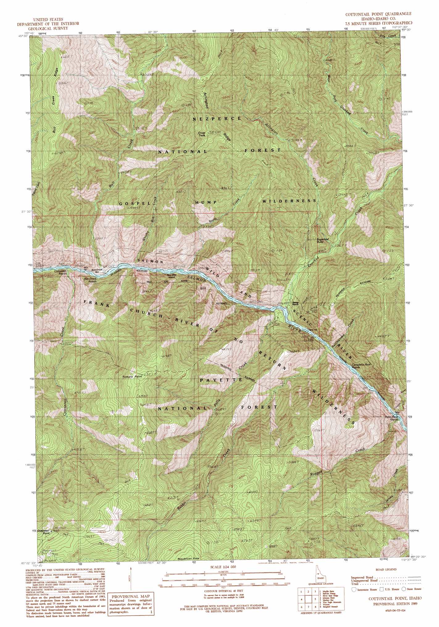
USGS Topo Quad 45115d6 - 1:24,000 scale
| Topo Map Name: | Cottontail Point |
| USGS Topo Quad ID: | 45115d6 |
| Print Size: | ca. 21 1/4" wide x 27" high |
| Southeast Coordinates: | 45.375° N latitude / 115.625° W longitude |
| Map Center Coordinates: | 45.4375° N latitude / 115.6875° W longitude |
| U.S. State: | ID |
| Filename: | o45115d6.jpg |
| Download Map JPG Image: | Cottontail Point topo map 1:24,000 scale |
| Map Type: | Topographic |
| Topo Series: | 7.5´ |
| Map Scale: | 1:24,000 |
| Source of Map Images: | United States Geological Survey (USGS) |
| Alternate Map Versions: |
Cottontail Point ID 1989, updated 1990 Download PDF Buy paper map Cottontail Point ID 1995, updated 1999 Download PDF Buy paper map Cottontail Point ID 2011 Download PDF Buy paper map Cottontail Point ID 2013 Download PDF Buy paper map |
| FStopo: | US Forest Service topo Cottontail Point is available: Download FStopo PDF Download FStopo TIF |
1:24,000 Topo Quads surrounding Cottontail Point
Sawyer Ridge |
Sourdough Peak |
North Pole |
Orogrande |
Moose Butte |
Hanover Mountain |
Marble Butte |
Buffalo Hump |
Silver Spur Ridge |
Dixie |
Carey Dome |
Johnson Butte |
Cottontail Point |
Mackay Bar |
Fivemile Bar |
Burgdorf |
War Eagle Mountain |
Warren |
Burgdorf Summit |
Chicken Peak |
Victor Peak |
Loon Lake |
Pony Meadows |
Pilot Peak |
Wolf Fang Peak |
> Back to 45115a1 at 1:100,000 scale
> Back to 45114a1 at 1:250,000 scale
> Back to U.S. Topo Maps home
Cottontail Point topo map: Gazetteer
Cottontail Point: Bars
Bull Creek Bar elevation 630m 2066′Cottontail Point: Populated Places
Cross Trails elevation 1776m 5826′Cottontail Point: Ridges
Arlington Ridge elevation 1665m 5462′Bull Creek Ridge elevation 2070m 6791′
Cottontail Point: Streams
Arlington Creek elevation 736m 2414′Basin Creek elevation 634m 2080′
Bull Creek elevation 635m 2083′
Cottontail Creek elevation 654m 2145′
Cougar Creek elevation 660m 2165′
Crooked Creek elevation 632m 2073′
Hurst Creek elevation 1284m 4212′
Polly Creek elevation 650m 2132′
Rabbit Creek elevation 672m 2204′
Rugged Creek elevation 687m 2253′
Whisky Bob Creek elevation 636m 2086′
Cottontail Point: Summits
Cottontail Point elevation 2335m 7660′Jim Thrash Knob elevation 2210m 7250′
Sugarloaf Butte elevation 887m 2910′
Tomato Point elevation 1932m 6338′
Cottontail Point digital topo map on disk
Buy this Cottontail Point topo map showing relief, roads, GPS coordinates and other geographical features, as a high-resolution digital map file on DVD: