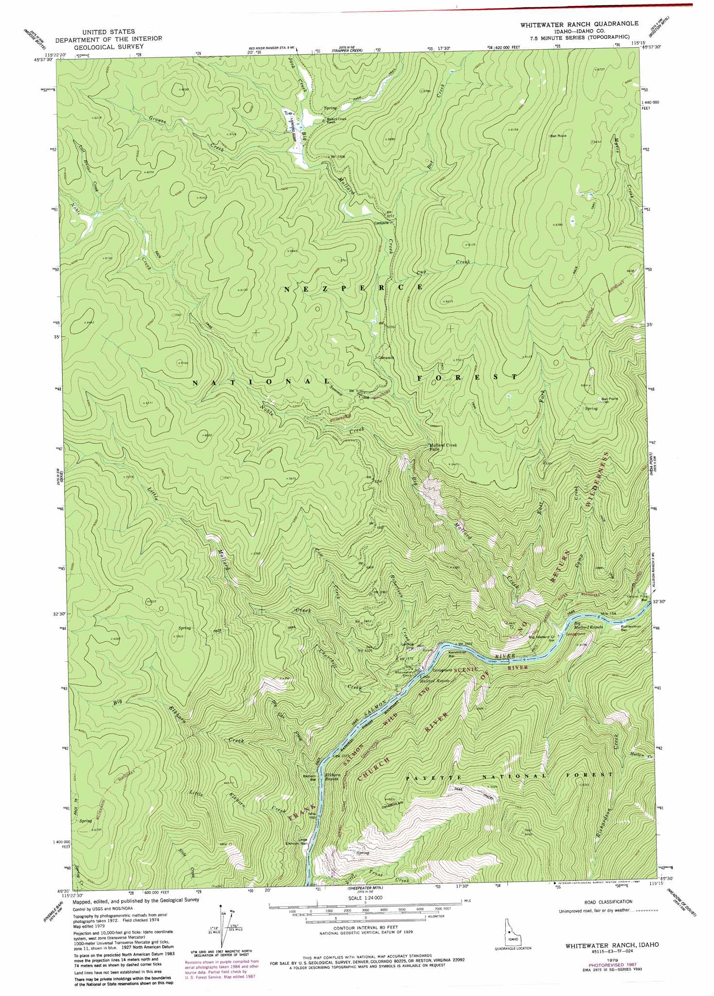
Whitewater Ranch Topo Map Idaho
To zoom in, hover over the map of Whitewater Ranch
USGS Topo Quad 45115e3 - 1:24,000 scale
| Topo Map Name: | Whitewater Ranch |
| USGS Topo Quad ID: | 45115e3 |
| Print Size: | ca. 21 1/4" wide x 27" high |
| Southeast Coordinates: | 45.5° N latitude / 115.25° W longitude |
| Map Center Coordinates: | 45.5625° N latitude / 115.3125° W longitude |
| U.S. State: | ID |
| Filename: | o45115e3.jpg |
| Download Map JPG Image: | Whitewater Ranch topo map 1:24,000 scale |
| Map Type: | Topographic |
| Topo Series: | 7.5´ |
| Map Scale: | 1:24,000 |
| Source of Map Images: | United States Geological Survey (USGS) |
| Alternate Map Versions: |
Whitewater Ranch ID 1979, updated 1987 Download PDF Buy paper map Whitewater Ranch ID 1995, updated 1999 Download PDF Buy paper map Whitewater Ranch ID 2011 Download PDF Buy paper map Whitewater Ranch ID 2013 Download PDF Buy paper map |
| FStopo: | US Forest Service topo Whitewater Ranch is available: Download FStopo PDF Download FStopo TIF |
1:24,000 Topo Quads surrounding Whitewater Ranch
Cener Star Mountain |
Elk City |
Black Hawk Mountain |
Sable Hill |
Green Mountain |
Orogrande |
Moose Butte |
Trapper Creek |
Boston Mountain |
Spread Creek Point |
Silver Spur Ridge |
Dixie |
Whitewater Ranch |
Hida Point |
Sheep Hill |
Mackay Bar |
Fivemile Bar |
Sheepeater Mountain |
Meadow Of Doubt |
Arctic Point |
Burgdorf Summit |
Chicken Peak |
Mosquito Peak |
Lodgepole Creek |
Wapiti Creek |
> Back to 45115e1 at 1:100,000 scale
> Back to 45114a1 at 1:250,000 scale
> Back to U.S. Topo Maps home
Whitewater Ranch topo map: Gazetteer
Whitewater Ranch: Bars
Big Mallard Creek Bar elevation 766m 2513′Elkhorn Bar elevation 910m 2985′
Kenmitzer Bar elevation 726m 2381′
Little Elkhorn Bar elevation 945m 3100′
Richardson Bar elevation 750m 2460′
Yellow Pine Bar elevation 781m 2562′
Whitewater Ranch: Falls
Mallard Creek Falls elevation 1450m 4757′Whitewater Ranch: Rapids
Big Mallard Rapids elevation 753m 2470′Elkhorn Rapids elevation 834m 2736′
Growler Rapids elevation 863m 2831′
Little Mallard Rapids elevation 786m 2578′
Whitewater Ranch: Streams
Bat Creek elevation 1582m 5190′Big Elkhorn Creek elevation 736m 2414′
Big Mallard Creek elevation 763m 2503′
Camp Creek elevation 791m 2595′
Churchill Creek elevation 811m 2660′
Cow Creek elevation 1110m 3641′
Cup Creek elevation 1662m 5452′
Dry Can Creek elevation 912m 2992′
East Fork Big Mallard Creek elevation 907m 2975′
Grouse Creek elevation 1625m 5331′
Harlan Creek elevation 1073m 3520′
Jack Creek elevation 1598m 5242′
Little Elkhorn Creek elevation 957m 3139′
Little Mallard Creek elevation 725m 2378′
Little Trout Creek elevation 926m 3038′
Noble Creek elevation 1275m 4183′
Richardson Creek elevation 754m 2473′
Robertson Creek elevation 794m 2604′
Summit Creek elevation 1581m 5187′
Whitewater Ranch: Summits
Bat Point elevation 1818m 5964′Vitta Point elevation 1567m 5141′
Whitewater Ranch digital topo map on disk
Buy this Whitewater Ranch topo map showing relief, roads, GPS coordinates and other geographical features, as a high-resolution digital map file on DVD: