Orogrande Topo Map Idaho
To zoom in, hover over the map of Orogrande
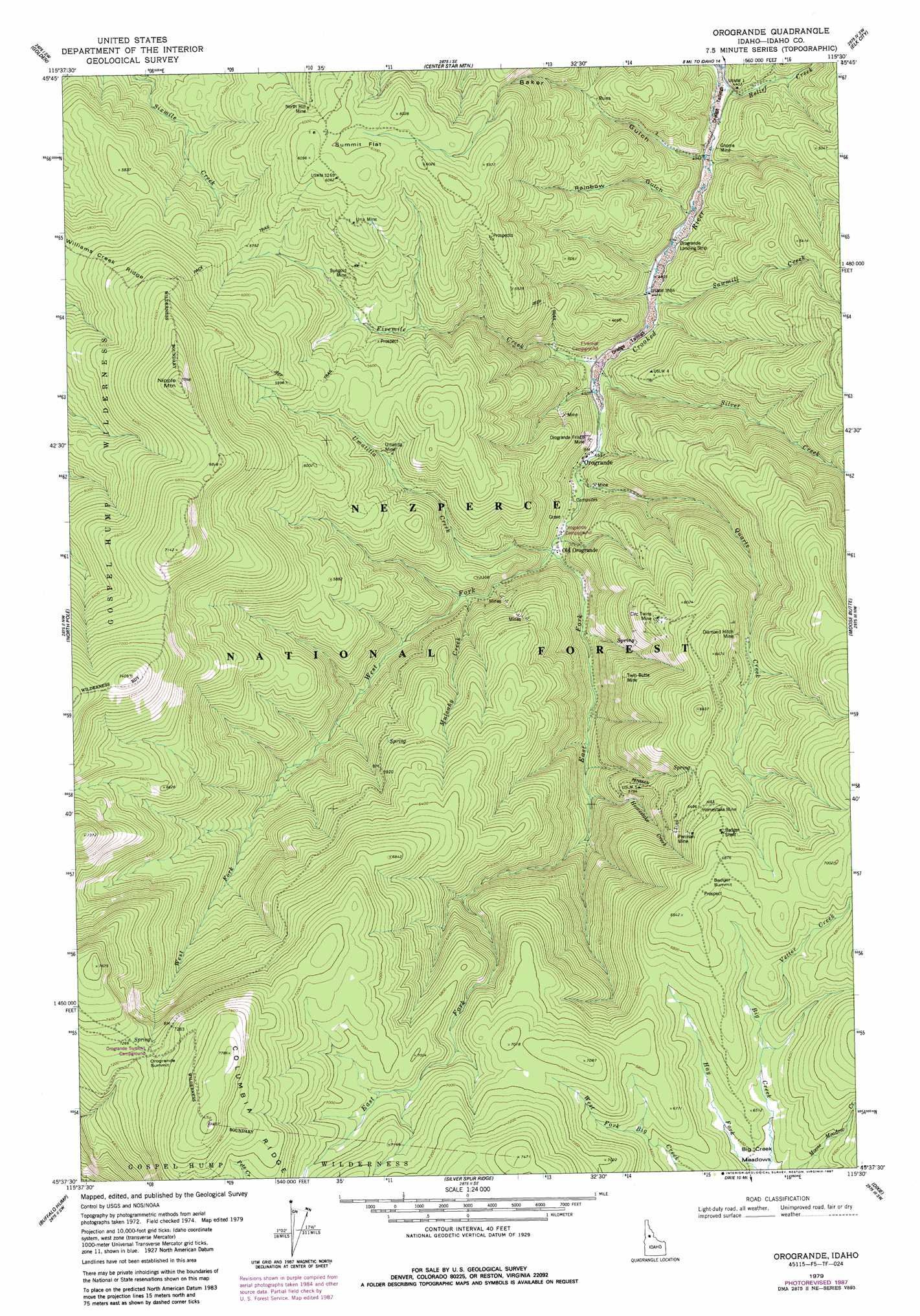
USGS Topo Quad 45115f5 - 1:24,000 scale
| Topo Map Name: | Orogrande |
| USGS Topo Quad ID: | 45115f5 |
| Print Size: | ca. 21 1/4" wide x 27" high |
| Southeast Coordinates: | 45.625° N latitude / 115.5° W longitude |
| Map Center Coordinates: | 45.6875° N latitude / 115.5625° W longitude |
| U.S. State: | ID |
| Filename: | o45115f5.jpg |
| Download Map JPG Image: | Orogrande topo map 1:24,000 scale |
| Map Type: | Topographic |
| Topo Series: | 7.5´ |
| Map Scale: | 1:24,000 |
| Source of Map Images: | United States Geological Survey (USGS) |
| Alternate Map Versions: |
Orogrande ID 1979, updated 1979 Download PDF Buy paper map Orogrande ID 1979, updated 1987 Download PDF Buy paper map Orogrande ID 1995, updated 1999 Download PDF Buy paper map Orogrande ID 2011 Download PDF Buy paper map Orogrande ID 2013 Download PDF Buy paper map |
| FStopo: | US Forest Service topo Orogrande is available: Download FStopo PDF Download FStopo TIF |
1:24,000 Topo Quads surrounding Orogrande
Corral Hill |
Pilot Knob |
Iron Mountain |
Lick Point |
Anderson Butte |
Huddleson Bluff |
Golden |
Cener Star Mountain |
Elk City |
Black Hawk Mountain |
Sourdough Peak |
North Pole |
Orogrande |
Moose Butte |
Trapper Creek |
Marble Butte |
Buffalo Hump |
Silver Spur Ridge |
Dixie |
Whitewater Ranch |
Johnson Butte |
Cottontail Point |
Mackay Bar |
Fivemile Bar |
Sheepeater Mountain |
> Back to 45115e1 at 1:100,000 scale
> Back to 45114a1 at 1:250,000 scale
> Back to U.S. Topo Maps home
Orogrande topo map: Gazetteer
Orogrande: Airports
Orogrande Landing Strip elevation 1337m 4386′Orogrande: Flats
Summit Flat elevation 1849m 6066′Orogrande: Mines
Circ Twins Mine elevation 1808m 5931′Diamond Hitch Mine elevation 1839m 6033′
Gnome Mine elevation 1332m 4370′
Homestake Mine elevation 1999m 6558′
North Hill Mine elevation 1797m 5895′
Old Orogrande Mine elevation 1571m 5154′
Orogrande Frisco Mine elevation 1419m 4655′
Penman Mine elevation 2009m 6591′
Sungold Mine elevation 1706m 5597′
Twin Butte Mine elevation 1717m 5633′
Umatilla Mine elevation 1643m 5390′
Una Mine elevation 1808m 5931′
Orogrande: Populated Places
Orogrande elevation 1398m 4586′Orogrande: Streams
East Fork Crooked River elevation 1435m 4708′Fivemile Creek elevation 1363m 4471′
Homestake Creek elevation 1560m 5118′
Mulcahy Creek elevation 1493m 4898′
Quartz Creek elevation 1395m 4576′
Relief Creek elevation 1310m 4297′
Sawmill Creek elevation 1354m 4442′
Silver Creek elevation 1364m 4475′
Umatilla Creek elevation 1425m 4675′
Vetter Creek elevation 1978m 6489′
West Fork Crooked River elevation 1425m 4675′
Orogrande: Summits
Nipple Mountain elevation 2160m 7086′Orogrande Summit elevation 2212m 7257′
Orogrande: Valleys
Baker Gulch elevation 1331m 4366′Rainbow Gulch elevation 1331m 4366′
Orogrande digital topo map on disk
Buy this Orogrande topo map showing relief, roads, GPS coordinates and other geographical features, as a high-resolution digital map file on DVD: