Sourdough Peak Topo Map Idaho
To zoom in, hover over the map of Sourdough Peak
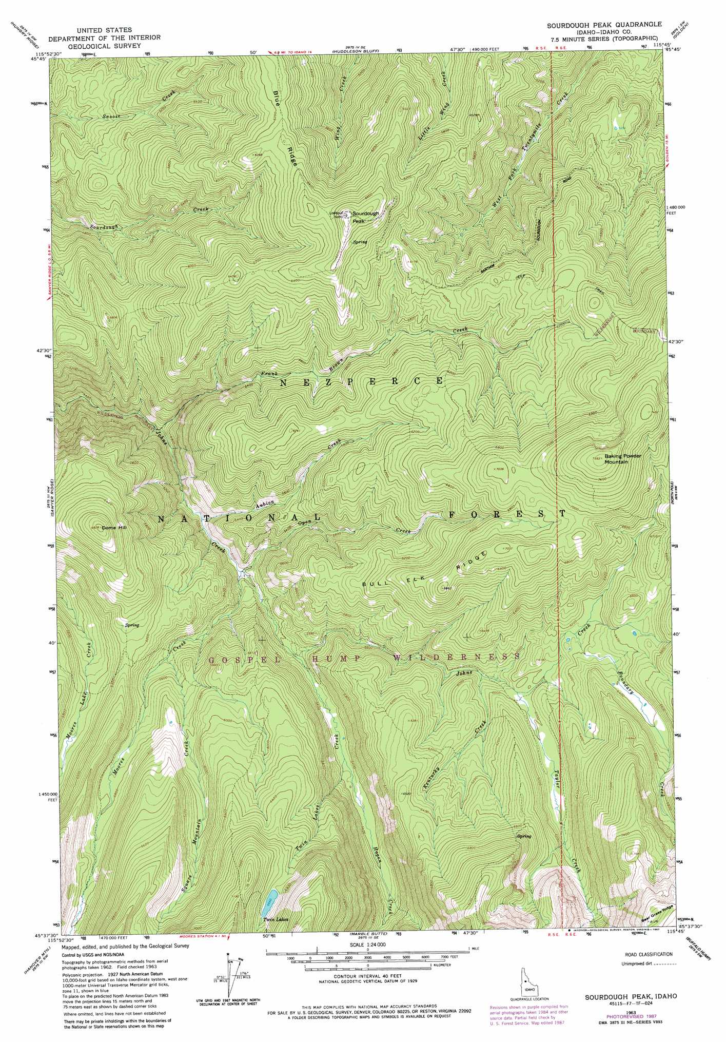
USGS Topo Quad 45115f7 - 1:24,000 scale
| Topo Map Name: | Sourdough Peak |
| USGS Topo Quad ID: | 45115f7 |
| Print Size: | ca. 21 1/4" wide x 27" high |
| Southeast Coordinates: | 45.625° N latitude / 115.75° W longitude |
| Map Center Coordinates: | 45.6875° N latitude / 115.8125° W longitude |
| U.S. State: | ID |
| Filename: | o45115f7.jpg |
| Download Map JPG Image: | Sourdough Peak topo map 1:24,000 scale |
| Map Type: | Topographic |
| Topo Series: | 7.5´ |
| Map Scale: | 1:24,000 |
| Source of Map Images: | United States Geological Survey (USGS) |
| Alternate Map Versions: |
Sourdough Peak ID 1963, updated 1964 Download PDF Buy paper map Sourdough Peak ID 1963, updated 1983 Download PDF Buy paper map Sourdough Peak ID 1963, updated 1987 Download PDF Buy paper map Sourdough Peak ID 1995, updated 1999 Download PDF Buy paper map Sourdough Peak ID 2011 Download PDF Buy paper map Sourdough Peak ID 2013 Download PDF Buy paper map |
| FStopo: | US Forest Service topo Sourdough Peak is available: Download FStopo PDF Download FStopo TIF |
1:24,000 Topo Quads surrounding Sourdough Peak
Grangeville East |
Harpster |
Corral Hill |
Pilot Knob |
Iron Mountain |
Goodwin Meadows |
Hungry Ridge |
Huddleson Bluff |
Golden |
Cener Star Mountain |
Dairy Mountain |
Sawyer Ridge |
Sourdough Peak |
North Pole |
Orogrande |
Florence |
Hanover Mountain |
Marble Butte |
Buffalo Hump |
Silver Spur Ridge |
Kelly Mountain |
Carey Dome |
Johnson Butte |
Cottontail Point |
Mackay Bar |
> Back to 45115e1 at 1:100,000 scale
> Back to 45114a1 at 1:250,000 scale
> Back to U.S. Topo Maps home
Sourdough Peak topo map: Gazetteer
Sourdough Peak: Lakes
Twin Lakes elevation 2186m 7171′Sourdough Peak: Ridges
Bull Elk Ridge elevation 2088m 6850′Sourdough Peak: Streams
Aubion Creek elevation 1492m 4895′Boundary Creek elevation 1873m 6145′
Frank Brown Creek elevation 1416m 4645′
Hagen Creek elevation 1629m 5344′
Kentucky Creek elevation 1772m 5813′
Moores Creek elevation 1520m 4986′
Open Creek elevation 1519m 4983′
Square Mountain Creek elevation 1654m 5426′
Taylor Creek elevation 1820m 5971′
Twin Lakes Creek elevation 1598m 5242′
Sourdough Peak: Summits
Baking Powder Mountain elevation 2310m 7578′Dome Hill elevation 2076m 6811′
Sourdough Peak elevation 2066m 6778′
Sourdough Peak digital topo map on disk
Buy this Sourdough Peak topo map showing relief, roads, GPS coordinates and other geographical features, as a high-resolution digital map file on DVD: