Butterfield Gulch Topo Map Idaho
To zoom in, hover over the map of Butterfield Gulch
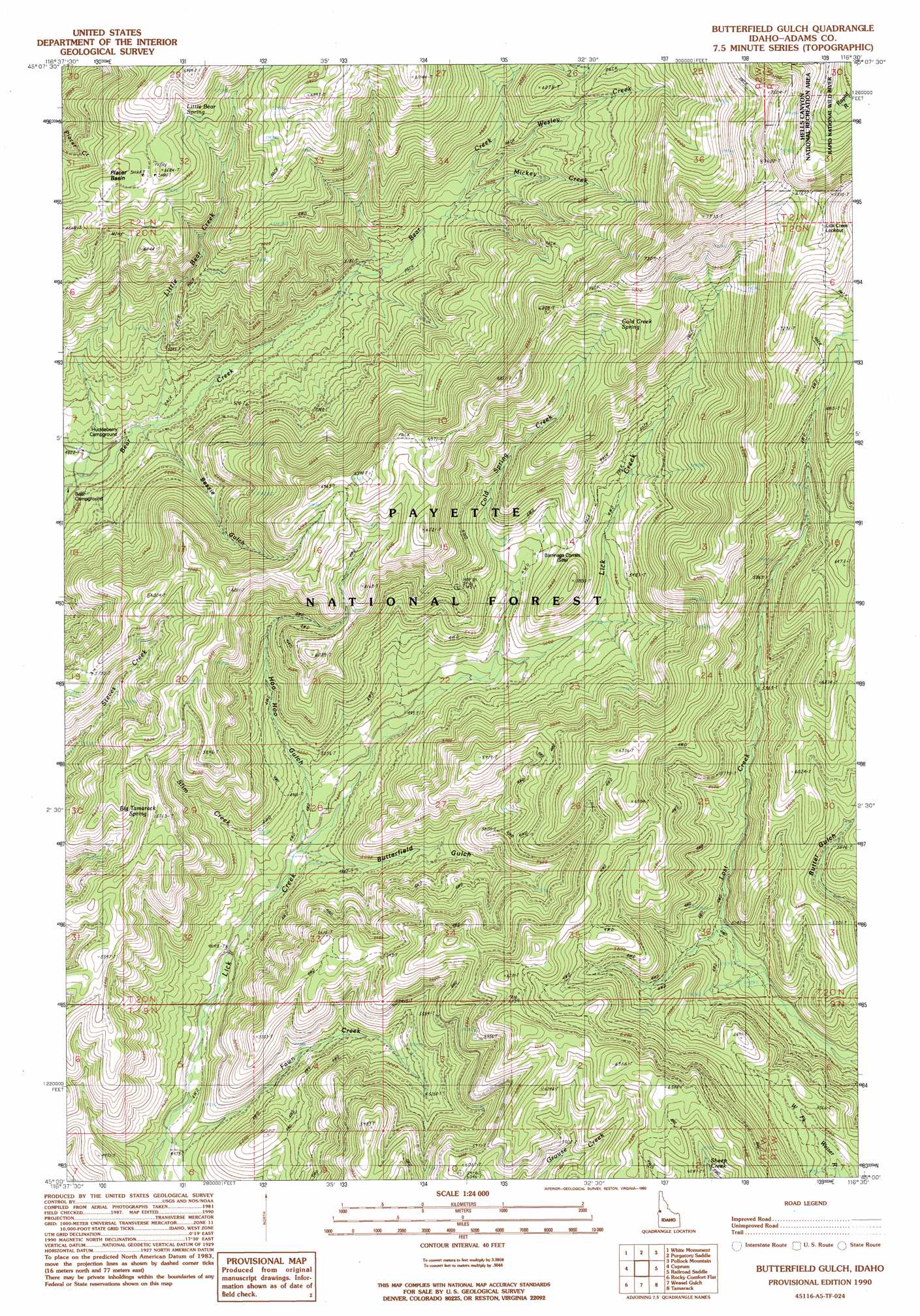
USGS Topo Quad 45116a5 - 1:24,000 scale
| Topo Map Name: | Butterfield Gulch |
| USGS Topo Quad ID: | 45116a5 |
| Print Size: | ca. 21 1/4" wide x 27" high |
| Southeast Coordinates: | 45° N latitude / 116.5° W longitude |
| Map Center Coordinates: | 45.0625° N latitude / 116.5625° W longitude |
| U.S. State: | ID |
| Filename: | o45116a5.jpg |
| Download Map JPG Image: | Butterfield Gulch topo map 1:24,000 scale |
| Map Type: | Topographic |
| Topo Series: | 7.5´ |
| Map Scale: | 1:24,000 |
| Source of Map Images: | United States Geological Survey (USGS) |
| Alternate Map Versions: |
Butterfield Gulch ID 1990, updated 1990 Download PDF Buy paper map Butterfield Gulch ID 2004, updated 2007 Download PDF Buy paper map Butterfield Gulch ID 2011 Download PDF Buy paper map Butterfield Gulch ID 2013 Download PDF Buy paper map |
| FStopo: | US Forest Service topo Butterfield Gulch is available: Download FStopo PDF Download FStopo TIF |
1:24,000 Topo Quads surrounding Butterfield Gulch
Jaynes Ridge |
Squirrel Prairie |
He Devil |
Heavens Gate |
Pollock |
Puderbaugh Ridge |
White Monument |
Purgatory Saddle |
Pollock Mountain |
Indian Mountain |
Homestead |
Cuprum |
Butterfield Gulch |
Railroad Saddle |
Bally Mountain |
Oxbow |
Rocky Comfort Flat |
Weasel Gulch |
Tamarack |
New Meadows |
Cuddy Mountain |
Crooked River Point |
Peck Mountain |
Fruitvale |
Cold Spring Summit |
> Back to 45116a1 at 1:100,000 scale
> Back to 45116a1 at 1:250,000 scale
> Back to U.S. Topo Maps home
Butterfield Gulch topo map: Gazetteer
Butterfield Gulch: Basins
Placer Basin elevation 1961m 6433′Butterfield Gulch: Springs
Big Tamarack Spring elevation 1659m 5442′Little Bear Spring elevation 1977m 6486′
Butterfield Gulch: Streams
Cold Spring Creek elevation 1538m 5045′Fawn Creek elevation 1363m 4471′
Little Bear Creek elevation 1480m 4855′
Mickey Creek elevation 1660m 5446′
Slim Creek elevation 1427m 4681′
Wesley Creek elevation 1695m 5561′
Butterfield Gulch: Valleys
Bessie Gulch elevation 1509m 4950′Butterfield Gulch elevation 1467m 4812′
Hoo Hoo Gulch elevation 1470m 4822′
Butterfield Gulch digital topo map on disk
Buy this Butterfield Gulch topo map showing relief, roads, GPS coordinates and other geographical features, as a high-resolution digital map file on DVD: