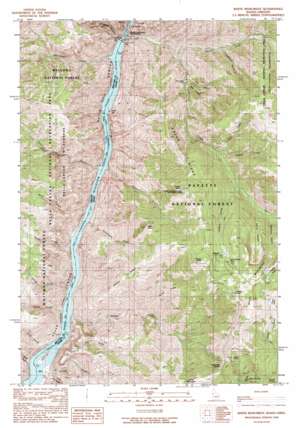
White Monument Topo Map Idaho
To zoom in, hover over the map of White Monument
USGS Topo Quad 45116b6 - 1:24,000 scale
| Topo Map Name: | White Monument |
| USGS Topo Quad ID: | 45116b6 |
| Print Size: | ca. 21 1/4" wide x 27" high |
| Southeast Coordinates: | 45.125° N latitude / 116.625° W longitude |
| Map Center Coordinates: | 45.1875° N latitude / 116.6875° W longitude |
| U.S. States: | ID, OR |
| Filename: | o45116b6.jpg |
| Download Map JPG Image: | White Monument topo map 1:24,000 scale |
| Map Type: | Topographic |
| Topo Series: | 7.5´ |
| Map Scale: | 1:24,000 |
| Source of Map Images: | United States Geological Survey (USGS) |
| Alternate Map Versions: |
White Monument ID 1990, updated 1990 Download PDF Buy paper map White Monument ID 2011 Download PDF Buy paper map White Monument ID 2013 Download PDF Buy paper map |
| FStopo: | US Forest Service topo White Monument is available: Download FStopo PDF Download FStopo TIF |
1:24,000 Topo Quads surrounding White Monument
> Back to 45116a1 at 1:100,000 scale
> Back to 45116a1 at 1:250,000 scale
> Back to U.S. Topo Maps home
White Monument topo map: Gazetteer
White Monument: Bars
Big Bar elevation 532m 1745′Eagle Bar elevation 514m 1686′
Fishers Bar elevation 546m 1791′
White Monument: Beaches
Red Ledge elevation 1104m 3622′White Monument: Cliffs
Black Point elevation 1919m 6295′Kinney Point elevation 2159m 7083′
White Monument: Dams
Hells Canyon Dam elevation 514m 1686′Hells Canyon Dam elevation 577m 1893′
White Monument: Flats
Pine Flat elevation 544m 1784′The Flatiron elevation 937m 3074′
White Monument: Gaps
Lockwood Saddle elevation 1938m 6358′White Monument: Mines
Alaska Mine elevation 1989m 6525′Bluejacket Mine elevation 1799m 5902′
Red Ledge Mine elevation 825m 2706′
South Peacock Mine elevation 2083m 6833′
White Monument: Populated Places
Helena elevation 2018m 6620′White Monument: Post Offices
Helena Post Office (historical) elevation 2018m 6620′White Monument: Reservoirs
Hells Canyon Reservoir elevation 577m 1893′Hells Canyon Reservoir elevation 483m 1584′
White Monument: Ridges
Grassy Ridge elevation 1603m 5259′Haley Ridge elevation 1720m 5643′
Tussel Ridge elevation 1743m 5718′
White Monument elevation 2288m 7506′
White Monument: Springs
Towsley Spring elevation 2133m 6998′White Monument: Streams
Allison Creek elevation 514m 1686′Buck Creek elevation 514m 1686′
Copper Creek elevation 2174m 7132′
Deep Creek elevation 465m 1525′
Dove Creek elevation 515m 1689′
Doyle Creek elevation 514m 1686′
Heady Creek elevation 1385m 4543′
Kinney Creek elevation 514m 1686′
Kirby Creek elevation 514m 1686′
Little Dry Gulch elevation 534m 1751′
Lynch Creek elevation 514m 1686′
Oxbow Creek elevation 693m 2273′
Sawpit Creek elevation 514m 1686′
Short Creek elevation 491m 1610′
Squaw Creek elevation 514m 1686′
Steamboat Creek elevation 514m 1686′
Thirtytwo Point Creek elevation 514m 1686′
Trail Creek elevation 1390m 4560′
White Monument: Summits
Sheep Rock elevation 2089m 6853′White Monument: Trails
Red Ledge Trail elevation 1184m 3884′Sheep Rock National Recreation Trail elevation 2071m 6794′
White Monument: Valleys
Anderson Gulch elevation 1119m 3671′Devils Hollow elevation 1862m 6108′
Dry Gulch elevation 514m 1686′
Hardrock Gulch elevation 1812m 5944′
Red Gulch elevation 822m 2696′
Schoolmam Gulch elevation 514m 1686′
Sucker Gulch elevation 2090m 6856′
White Monument digital topo map on disk
Buy this White Monument topo map showing relief, roads, GPS coordinates and other geographical features, as a high-resolution digital map file on DVD:


