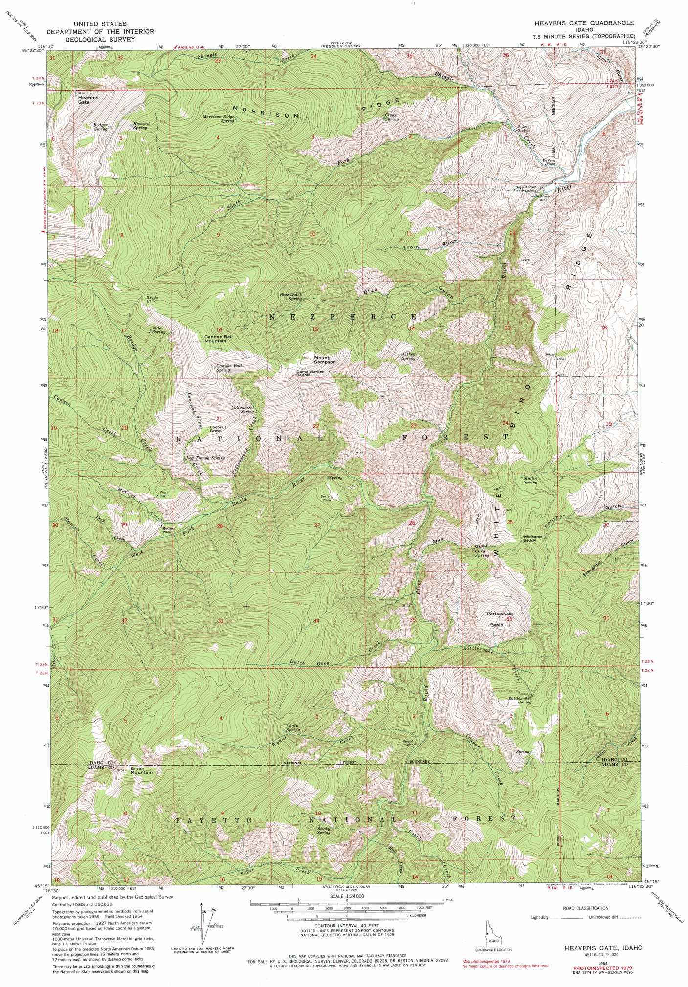
Heavens Gate Topo Map Idaho
To zoom in, hover over the map of Heavens Gate
USGS Topo Quad 45116c4 - 1:24,000 scale
| Topo Map Name: | Heavens Gate |
| USGS Topo Quad ID: | 45116c4 |
| Print Size: | ca. 21 1/4" wide x 27" high |
| Southeast Coordinates: | 45.25° N latitude / 116.375° W longitude |
| Map Center Coordinates: | 45.3125° N latitude / 116.4375° W longitude |
| U.S. State: | ID |
| Filename: | o45116c4.jpg |
| Download Map JPG Image: | Heavens Gate topo map 1:24,000 scale |
| Map Type: | Topographic |
| Topo Series: | 7.5´ |
| Map Scale: | 1:24,000 |
| Source of Map Images: | United States Geological Survey (USGS) |
| Alternate Map Versions: |
Heavens Gate ID 1964, updated 1966 Download PDF Buy paper map Heavens Gate ID 1964, updated 1979 Download PDF Buy paper map Heavens Gate ID 1964, updated 1986 Download PDF Buy paper map Heavens Gate ID 1964, updated 1986 Download PDF Buy paper map Heavens Gate ID 1995, updated 1999 Download PDF Buy paper map Heavens Gate ID 2011 Download PDF Buy paper map Heavens Gate ID 2013 Download PDF Buy paper map |
| FStopo: | US Forest Service topo Heavens Gate is available: Download FStopo PDF Download FStopo TIF |
1:24,000 Topo Quads surrounding Heavens Gate
Sleepy Ridge |
Temperance Creek |
Kirkwood Creek |
Lucile |
John Day Mountain |
Hat Point |
Old Time Mountain |
Kessler Creek |
Riggins |
Riggins Hot Springs |
Squirrel Prairie |
He Devil |
Heavens Gate |
Pollock |
Patrick Butte |
White Monument |
Purgatory Saddle |
Pollock Mountain |
Indian Mountain |
Hazard Lake |
Cuprum |
Butterfield Gulch |
Railroad Saddle |
Bally Mountain |
Brundage Mountain |
> Back to 45116a1 at 1:100,000 scale
> Back to 45116a1 at 1:250,000 scale
> Back to U.S. Topo Maps home
Heavens Gate topo map: Gazetteer
Heavens Gate: Basins
Rattlesnake Basin elevation 1379m 4524′Heavens Gate: Gaps
Game Warden Saddle elevation 1934m 6345′Wildhorse Saddle elevation 1559m 5114′
Heavens Gate: Mines
Oregon Tipton Mnine elevation 1233m 4045′Heavens Gate: Populated Places
DeVeny Place elevation 704m 2309′McCrea Place elevation 1227m 4025′
Potter Place elevation 1158m 3799′
Heavens Gate: Ridges
Morrison Ridge elevation 1681m 5515′White Bird Ridge elevation 1393m 4570′
Heavens Gate: Springs
Aitken Spring elevation 1495m 4904′Alder Spring elevation 1906m 6253′
Blue Gulch Spring elevation 1540m 5052′
Cannon Ball Spring elevation 2065m 6774′
Chain Spring elevation 1799m 5902′
Clyde Spring elevation 1338m 4389′
Cora Spring elevation 1295m 4248′
Cottonwood Spring elevation 1607m 5272′
Howard Spring elevation 2104m 6902′
Log Trough Spring elevation 1477m 4845′
Morrison Ridge Spring elevation 1889m 6197′
Mullin Spring elevation 1484m 4868′
Rattlesnake Spring elevation 1548m 5078′
Rodger Spring elevation 2221m 7286′
Smoky Spring elevation 1294m 4245′
Heavens Gate: Streams
Bridge Creek elevation 1074m 3523′Cannon Creek elevation 1455m 4773′
Castle Creek elevation 1038m 3405′
Coconut Grove Creek elevation 1230m 4035′
Copper Creek elevation 1073m 3520′
Cottonwood Creek elevation 1084m 3556′
Cougar Creek elevation 962m 3156′
Deep Creek elevation 1255m 4117′
Dutch Oven Creek elevation 925m 3034′
Hall Creek elevation 1055m 3461′
Hanson Creek elevation 1320m 4330′
McCrea Creek elevation 1109m 3638′
Rattlesnake Creek elevation 927m 3041′
Shingle Creek elevation 665m 2181′
South Fork Shingle Creek elevation 789m 2588′
West Fork Rapid River elevation 829m 2719′
Wyant Creek elevation 977m 3205′
Heavens Gate: Summits
Bryan Mountain elevation 2541m 8336′Cannon Ball Mountain elevation 2188m 7178′
Heavens Gate elevation 2554m 8379′
Mount Sampson elevation 1965m 6446′
Heavens Gate: Valleys
Alvin Gulch elevation 670m 2198′Blue Gulch elevation 731m 2398′
Cora Gulch elevation 892m 2926′
Thorn Gulch elevation 692m 2270′
Heavens Gate: Woods
Coconut Grove elevation 1668m 5472′Heavens Gate digital topo map on disk
Buy this Heavens Gate topo map showing relief, roads, GPS coordinates and other geographical features, as a high-resolution digital map file on DVD: