Kelly Mountain Topo Map Idaho
To zoom in, hover over the map of Kelly Mountain
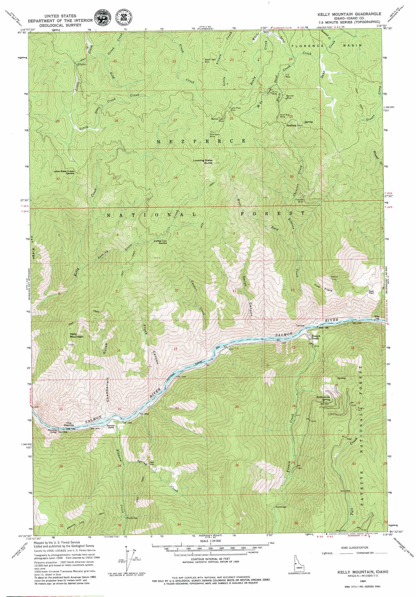
USGS Topo Quad 45116d1 - 1:24,000 scale
| Topo Map Name: | Kelly Mountain |
| USGS Topo Quad ID: | 45116d1 |
| Print Size: | ca. 21 1/4" wide x 27" high |
| Southeast Coordinates: | 45.375° N latitude / 116° W longitude |
| Map Center Coordinates: | 45.4375° N latitude / 116.0625° W longitude |
| U.S. State: | ID |
| Filename: | o45116d1.jpg |
| Download Map JPG Image: | Kelly Mountain topo map 1:24,000 scale |
| Map Type: | Topographic |
| Topo Series: | 7.5´ |
| Map Scale: | 1:24,000 |
| Source of Map Images: | United States Geological Survey (USGS) |
| Alternate Map Versions: |
Kelly Mountain ID 1964, updated 1966 Download PDF Buy paper map Kelly Mountain ID 1995, updated 1999 Download PDF Buy paper map Kelly Mountain ID 2011 Download PDF Buy paper map Kelly Mountain ID 2013 Download PDF Buy paper map |
| FStopo: | US Forest Service topo Kelly Mountain is available: Download FStopo PDF Download FStopo TIF |
1:24,000 Topo Quads surrounding Kelly Mountain
Slate Creek |
Mckinzie Creek |
Dairy Mountain |
Sawyer Ridge |
Sourdough Peak |
Lucile |
John Day Mountain |
Florence |
Hanover Mountain |
Marble Butte |
Riggins |
Riggins Hot Springs |
Kelly Mountain |
Carey Dome |
Johnson Butte |
Pollock |
Patrick Butte |
Hershey Point |
Burgdorf |
War Eagle Mountain |
Indian Mountain |
Hazard Lake |
Black Tip |
Victor Peak |
Loon Lake |
> Back to 45116a1 at 1:100,000 scale
> Back to 45116a1 at 1:250,000 scale
> Back to U.S. Topo Maps home
Kelly Mountain topo map: Gazetteer
Kelly Mountain: Bridges
Manning Bridge elevation 557m 1827′Kelly Mountain: Flats
Cow Flats elevation 1076m 3530′Kelly Mountain: Gaps
Coffee Can Saddle elevation 1720m 5643′Little Slate Creek Saddle elevation 1665m 5462′
Kelly Mountain: Mines
Banner Mine elevation 1885m 6184′Black Bear Mine elevation 1854m 6082′
Gold Bug Mine elevation 1919m 6295′
Hi Yu Mine elevation 1892m 6207′
Lone Pine Mine elevation 1924m 6312′
Mother Lode Mine elevation 1946m 6384′
Poorman Mine elevation 1911m 6269′
US Mine elevation 1862m 6108′
Yakima Mine elevation 1529m 5016′
Kelly Mountain: Populated Places
French Creek elevation 596m 1955′Seaburg elevation 1990m 6528′
Kelly Mountain: Post Offices
French Creek Post Office (historical) elevation 596m 1955′Kelly Mountain: Springs
Rattlesnake Spring elevation 1052m 3451′Kelly Mountain: Streams
Burn Creek elevation 1571m 5154′Chessler Creek elevation 1263m 4143′
Elkhorn Creek elevation 566m 1856′
French Creek elevation 580m 1902′
Gasper Creek elevation 583m 1912′
Gold Creek elevation 1577m 5173′
Greek Creek elevation 1597m 5239′
Healy Creek elevation 1854m 6082′
Hi Yu Creek elevation 1859m 6099′
Looking Glass Creek elevation 1071m 3513′
Robbins Creek elevation 583m 1912′
Spring Creek elevation 691m 2267′
Summit Creek elevation 1844m 6049′
West Fork Robbins Creek elevation 1010m 3313′
White Sand Creek elevation 1846m 6056′
Kelly Mountain: Summits
Kelly Mountain elevation 1466m 4809′Looking Glass Butte elevation 1967m 6453′
Kelly Mountain: Trails
Broken Leg Trail elevation 1308m 4291′Kelly Mountain: Valleys
Chamberlain Gulch elevation 575m 1886′Flock Canyon elevation 572m 1876′
Smith Canyon elevation 581m 1906′
Kelly Mountain digital topo map on disk
Buy this Kelly Mountain topo map showing relief, roads, GPS coordinates and other geographical features, as a high-resolution digital map file on DVD: