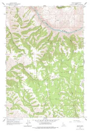
Boles Topo Map Idaho
To zoom in, hover over the map of Boles
USGS Topo Quad 45116h5 - 1:24,000 scale
| Topo Map Name: | Boles |
| USGS Topo Quad ID: | 45116h5 |
| Print Size: | ca. 21 1/4" wide x 27" high |
| Southeast Coordinates: | 45.875° N latitude / 116.5° W longitude |
| Map Center Coordinates: | 45.9375° N latitude / 116.5625° W longitude |
| U.S. State: | ID |
| Filename: | o45116h5.jpg |
| Download Map JPG Image: | Boles topo map 1:24,000 scale |
| Map Type: | Topographic |
| Topo Series: | 7.5´ |
| Map Scale: | 1:24,000 |
| Source of Map Images: | United States Geological Survey (USGS) |
| Alternate Map Versions: |
Boles ID 1963, updated 1965 Download PDF Buy paper map Boles ID 1963, updated 1977 Download PDF Buy paper map Boles ID 2010 Download PDF Buy paper map Boles ID 2013 Download PDF Buy paper map |
| FStopo: | US Forest Service topo Boles is available: Download FStopo PDF Download FStopo TIF |
1:24,000 Topo Quads surrounding Boles
> Back to 45116e1 at 1:100,000 scale
> Back to 45116a1 at 1:250,000 scale
> Back to U.S. Topo Maps home
Boles topo map: Gazetteer
Boles: Bars
White House Bar elevation 365m 1197′Boles: Flats
Joseph Plains elevation 1490m 4888′Boles: Populated Places
Boles elevation 1387m 4550′Boles: Streams
Burnt Creek elevation 364m 1194′Home Sweet Home Creek elevation 365m 1197′
Kylie Creek elevation 629m 2063′
Mahoney Creek elevation 369m 1210′
Rickman Creek elevation 357m 1171′
Round Spring Creek elevation 414m 1358′
Boles: Valleys
Ruggles Gulch elevation 375m 1230′Boles digital topo map on disk
Buy this Boles topo map showing relief, roads, GPS coordinates and other geographical features, as a high-resolution digital map file on DVD:


