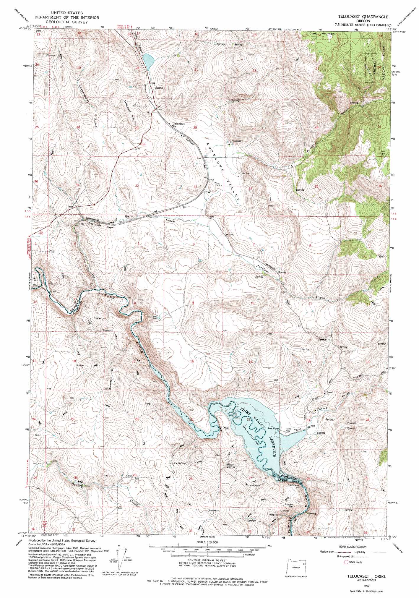
Telocaset Topo Map Oregon
To zoom in, hover over the map of Telocaset
USGS Topo Quad 45117a7 - 1:24,000 scale
| Topo Map Name: | Telocaset |
| USGS Topo Quad ID: | 45117a7 |
| Print Size: | ca. 21 1/4" wide x 27" high |
| Southeast Coordinates: | 45° N latitude / 117.75° W longitude |
| Map Center Coordinates: | 45.0625° N latitude / 117.8125° W longitude |
| U.S. State: | OR |
| Filename: | o45117a7.jpg |
| Download Map JPG Image: | Telocaset topo map 1:24,000 scale |
| Map Type: | Topographic |
| Topo Series: | 7.5´ |
| Map Scale: | 1:24,000 |
| Source of Map Images: | United States Geological Survey (USGS) |
| Alternate Map Versions: |
Telocaset OR 1965, updated 1967 Download PDF Buy paper map Telocaset OR 1965, updated 1985 Download PDF Buy paper map Telocaset OR 1993, updated 1993 Download PDF Buy paper map Telocaset OR 2011 Download PDF Buy paper map Telocaset OR 2014 Download PDF Buy paper map |
| FStopo: | US Forest Service topo Telocaset is available: Download FStopo PDF Download FStopo TIF |
1:24,000 Topo Quads surrounding Telocaset
La Grande |
Conley |
Cove |
Mount Fanny |
Jim White Ridge |
Glass Hill |
Craig Mountain |
Union |
Little Catherine Creek |
China Cap |
Tucker Flat |
North Powder |
Telocaset |
Medical Springs |
Flagstaff Butte |
Rock Creek |
Haines |
Magpie Peak |
Keating Nw |
Sawtooth Ridge |
Elkhorn Peak |
Wingville |
Baker |
Virtue Flat |
Keating |
> Back to 45117a1 at 1:100,000 scale
> Back to 45116a1 at 1:250,000 scale
> Back to U.S. Topo Maps home
Telocaset topo map: Gazetteer
Telocaset: Dams
Thief Valley Dam elevation 951m 3120′Telocaset: Parks
Thief Valley County Park elevation 959m 3146′Telocaset: Populated Places
Telocaset elevation 1053m 3454′Telocaset: Post Offices
Cromwell Post Office (historical) elevation 1038m 3405′Telocaset Post Office (historical) elevation 1053m 3454′
Telocaset: Reservoirs
Thief Valley Reservoir elevation 951m 3120′Telocaset: Springs
Foley Spring elevation 1086m 3562′Glass Spring elevation 1020m 3346′
Lynch Spring elevation 1596m 5236′
Telocaset: Streams
Antelope Creek elevation 963m 3159′Cusick Creek elevation 957m 3139′
Prescott Creek elevation 1021m 3349′
Spring Creek elevation 958m 3143′
Telocaset: Summits
Clark Mountain elevation 1689m 5541′Riverdale Hill elevation 1211m 3973′
Telocaset Hill elevation 1116m 3661′
Telocaset: Valleys
Antelope Valley elevation 1050m 3444′Government Gulch elevation 1007m 3303′
Prescott Gulch elevation 1064m 3490′
Thief Valley elevation 959m 3146′
Telocaset digital topo map on disk
Buy this Telocaset topo map showing relief, roads, GPS coordinates and other geographical features, as a high-resolution digital map file on DVD: