China Cap Topo Map Oregon
To zoom in, hover over the map of China Cap
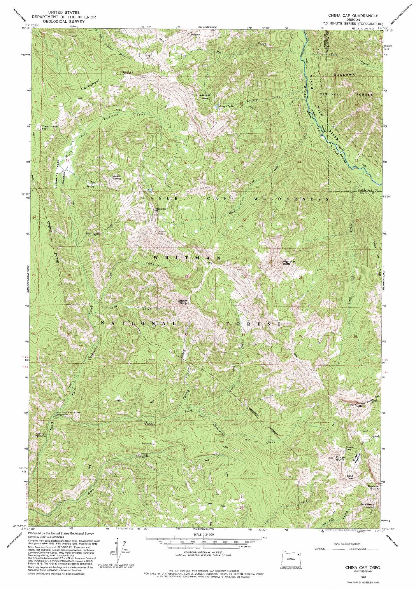
USGS Topo Quad 45117b5 - 1:24,000 scale
| Topo Map Name: | China Cap |
| USGS Topo Quad ID: | 45117b5 |
| Print Size: | ca. 21 1/4" wide x 27" high |
| Southeast Coordinates: | 45.125° N latitude / 117.5° W longitude |
| Map Center Coordinates: | 45.1875° N latitude / 117.5625° W longitude |
| U.S. State: | OR |
| Filename: | o45117b5.jpg |
| Download Map JPG Image: | China Cap topo map 1:24,000 scale |
| Map Type: | Topographic |
| Topo Series: | 7.5´ |
| Map Scale: | 1:24,000 |
| Source of Map Images: | United States Geological Survey (USGS) |
| Alternate Map Versions: |
China Cap OR 1965, updated 1967 Download PDF Buy paper map China Cap OR 1965, updated 1985 Download PDF Buy paper map China Cap OR 1993, updated 1993 Download PDF Buy paper map China Cap OR 2011 Download PDF Buy paper map China Cap OR 2014 Download PDF Buy paper map |
| FStopo: | US Forest Service topo China Cap is available: Download FStopo PDF Download FStopo TIF |
1:24,000 Topo Quads surrounding China Cap
Gassett Bluff |
Mount Moriah |
Fox Point |
Lostine |
Enterprise |
Cove |
Mount Fanny |
Jim White Ridge |
North Minam Meadows |
Chief Joseph Mountain |
Union |
Little Catherine Creek |
China Cap |
Steamboat Lake |
Eagle Cap |
Telocaset |
Medical Springs |
Flagstaff Butte |
Bennet Peak |
Krag Peak |
Magpie Peak |
Keating Nw |
Sawtooth Ridge |
Balm Creek Reservoir |
Sparta Butte |
> Back to 45117a1 at 1:100,000 scale
> Back to 45116a1 at 1:250,000 scale
> Back to U.S. Topo Maps home
China Cap topo map: Gazetteer
China Cap: Bends
Lackeys Hole elevation 2188m 7178′China Cap: Flats
Burger Meadows elevation 2302m 7552′Catherine Creek Meadow elevation 1721m 5646′
Deadhorse Flat elevation 1974m 6476′
China Cap: Gaps
Burger Pass elevation 2392m 7847′Sand Pass elevation 2446m 8024′
China Cap: Lakes
Lackeys Lake elevation 2180m 7152′China Cap: Ridges
Cartwheel Ridge elevation 2227m 7306′China Cap: Springs
Amelia Spring elevation 2063m 6768′China Cap: Streams
Boot Hill Creek elevation 1610m 5282′China Cap Creek elevation 1406m 4612′
Chop Creek elevation 1507m 4944′
Jim Creek elevation 1530m 5019′
Lackey Creek elevation 1356m 4448′
Middle Catherine Creek elevation 1273m 4176′
Middle Fork Catherine Creek elevation 1273m 4176′
Pole Creek elevation 1337m 4386′
Pot Creek elevation 1343m 4406′
Rock Creek elevation 1381m 4530′
Spring Creek elevation 1549m 5082′
Squaw Creek elevation 1594m 5229′
China Cap: Summits
Burger Butte elevation 2572m 8438′China Cap elevation 2632m 8635′
Granite Butte elevation 2641m 8664′
High Hat Butte elevation 2475m 8120′
Meadow Mountain elevation 2385m 7824′
Mule Peak elevation 2608m 8556′
Squaw Butte elevation 2406m 7893′
China Cap digital topo map on disk
Buy this China Cap topo map showing relief, roads, GPS coordinates and other geographical features, as a high-resolution digital map file on DVD: