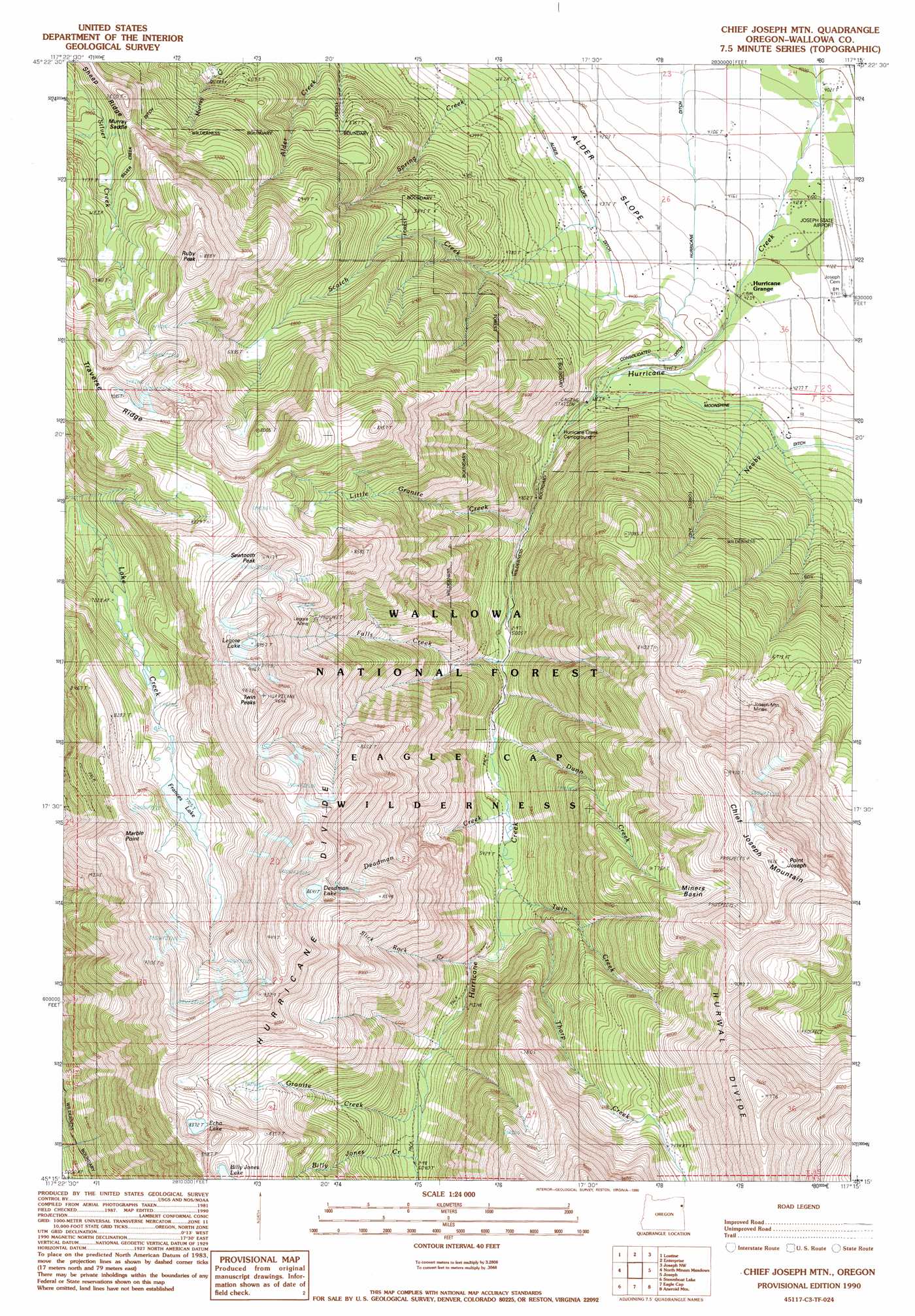
Chief Joseph Mountain Topo Map Oregon
To zoom in, hover over the map of Chief Joseph Mountain
USGS Topo Quad 45117c3 - 1:24,000 scale
| Topo Map Name: | Chief Joseph Mountain |
| USGS Topo Quad ID: | 45117c3 |
| Print Size: | ca. 21 1/4" wide x 27" high |
| Southeast Coordinates: | 45.25° N latitude / 117.25° W longitude |
| Map Center Coordinates: | 45.3125° N latitude / 117.3125° W longitude |
| U.S. State: | OR |
| Filename: | o45117c3.jpg |
| Download Map JPG Image: | Chief Joseph Mountain topo map 1:24,000 scale |
| Map Type: | Topographic |
| Topo Series: | 7.5´ |
| Map Scale: | 1:24,000 |
| Source of Map Images: | United States Geological Survey (USGS) |
| Alternate Map Versions: |
Chief Joseph Mtn OR 1990, updated 1990 Download PDF Buy paper map Chief Joseph Mtn OR 1990, updated 1990 Download PDF Buy paper map Chief Joseph Mtn OR 1990, updated 1990 Download PDF Buy paper map Chief Joseph Mountain OR 2011 Download PDF Buy paper map Chief Joseph Mountain OR 2014 Download PDF Buy paper map |
| FStopo: | US Forest Service topo Chief Joseph Mountain is available: Download FStopo PDF Download FStopo TIF |
1:24,000 Topo Quads surrounding Chief Joseph Mountain
Wallowa |
Evans |
Hicks Spring |
Elk Mountain |
Elk Mountain Se |
Fox Point |
Lostine |
Enterprise |
Joseph Nw |
Three Lakes Country |
Jim White Ridge |
North Minam Meadows |
Chief Joseph Mountain |
Joseph |
Kinney Lake |
China Cap |
Steamboat Lake |
Eagle Cap |
Aneroid Mountain |
Lick Creek |
Flagstaff Butte |
Bennet Peak |
Krag Peak |
Cornucopia |
Deadman Point |
> Back to 45117a1 at 1:100,000 scale
> Back to 45116a1 at 1:250,000 scale
> Back to U.S. Topo Maps home
Chief Joseph Mountain topo map: Gazetteer
Chief Joseph Mountain: Airports
Joseph State Airport elevation 1262m 4140′Chief Joseph Mountain: Basins
Miners Basin elevation 2396m 7860′Chief Joseph Mountain: Canals
Consolidated Ditch elevation 1367m 4484′Hurricane Ditch elevation 1263m 4143′
Silver Grange Ditch elevation 2270m 7447′
Chief Joseph Mountain: Flats
Granite Meadow elevation 2417m 7929′Chief Joseph Mountain: Gaps
Murray Saddle elevation 2145m 7037′Chief Joseph Mountain: Lakes
Deadman Lake elevation 2643m 8671′Echo Lake elevation 2559m 8395′
Francis Lake elevation 2350m 7709′
Legore Lake elevation 2728m 8950′
Chief Joseph Mountain: Mines
Joseph Mountain Mines elevation 2285m 7496′Legore Mine elevation 2321m 7614′
Chief Joseph Mountain: Rapids
Hurricane Rapids elevation 1703m 5587′Chief Joseph Mountain: Ridges
Hurricane Divide elevation 2883m 9458′Hurwal Divide elevation 2981m 9780′
Traverse Ridge elevation 2770m 9087′
Chief Joseph Mountain: Streams
Billy Jones Creek elevation 1838m 6030′Deadman Creek elevation 1642m 5387′
Dunn Creek elevation 1619m 5311′
Falls Creek elevation 1557m 5108′
Granite Creek elevation 1832m 6010′
Little Granite Creek elevation 1481m 4858′
Mill Creek elevation 1364m 4475′
Newby Creek elevation 1276m 4186′
Slick Rock Creek elevation 1750m 5741′
Spring Creek elevation 1478m 4849′
Thorp Creek elevation 1691m 5547′
Twin Creek elevation 1672m 5485′
Chief Joseph Mountain: Summits
Chief Joseph Mountain elevation 2929m 9609′Hurricane Point elevation 2552m 8372′
Point Joseph elevation 2933m 9622′
Ruby Peak elevation 2697m 8848′
Sawtooth Peak elevation 2790m 9153′
Twin Peaks elevation 2929m 9609′
Chief Joseph Mountain digital topo map on disk
Buy this Chief Joseph Mountain topo map showing relief, roads, GPS coordinates and other geographical features, as a high-resolution digital map file on DVD: