Gassett Bluff Topo Map Oregon
To zoom in, hover over the map of Gassett Bluff
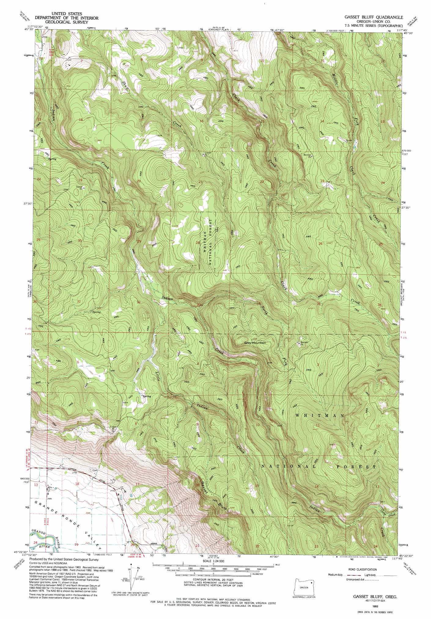
USGS Topo Quad 45117d7 - 1:24,000 scale
| Topo Map Name: | Gassett Bluff |
| USGS Topo Quad ID: | 45117d7 |
| Print Size: | ca. 21 1/4" wide x 27" high |
| Southeast Coordinates: | 45.375° N latitude / 117.75° W longitude |
| Map Center Coordinates: | 45.4375° N latitude / 117.8125° W longitude |
| U.S. State: | OR |
| Filename: | o45117d7.jpg |
| Download Map JPG Image: | Gassett Bluff topo map 1:24,000 scale |
| Map Type: | Topographic |
| Topo Series: | 7.5´ |
| Map Scale: | 1:24,000 |
| Source of Map Images: | United States Geological Survey (USGS) |
| Alternate Map Versions: |
Gasset Bluff OR 1965, updated 1967 Download PDF Buy paper map Gasset Bluff OR 1965, updated 1985 Download PDF Buy paper map Gasset Bluff OR 1993, updated 1993 Download PDF Buy paper map Gasset Bluff OR 2011 Download PDF Buy paper map Gasset Bluff OR 2014 Download PDF Buy paper map |
| FStopo: | US Forest Service topo Gasset Bluff is available: Download FStopo PDF Download FStopo TIF |
1:24,000 Topo Quads surrounding Gassett Bluff
Andies Prairie |
Partridge Creek |
Rondowa |
Howard Butte |
Akers Butte |
Sanderson Spring |
Elgin |
Cricket Flat |
Minam |
Wallowa |
Summerville |
Imbler |
Gassett Bluff |
Mount Moriah |
Fox Point |
La Grande |
Conley |
Cove |
Mount Fanny |
Jim White Ridge |
Glass Hill |
Craig Mountain |
Union |
Little Catherine Creek |
China Cap |
> Back to 45117a1 at 1:100,000 scale
> Back to 45116a1 at 1:250,000 scale
> Back to U.S. Topo Maps home
Gassett Bluff topo map: Gazetteer
Gassett Bluff: Cliffs
Gasset Bluff elevation 1491m 4891′Gassett Bluff: Streams
Camp Creek elevation 1454m 4770′Little Indian Creek elevation 1124m 3687′
North Fork Indian Creek elevation 1179m 3868′
Gassett Bluff: Summits
Grey Mountain elevation 1419m 4655′Gassett Bluff digital topo map on disk
Buy this Gassett Bluff topo map showing relief, roads, GPS coordinates and other geographical features, as a high-resolution digital map file on DVD: