Table Mountain Topo Map Oregon
To zoom in, hover over the map of Table Mountain
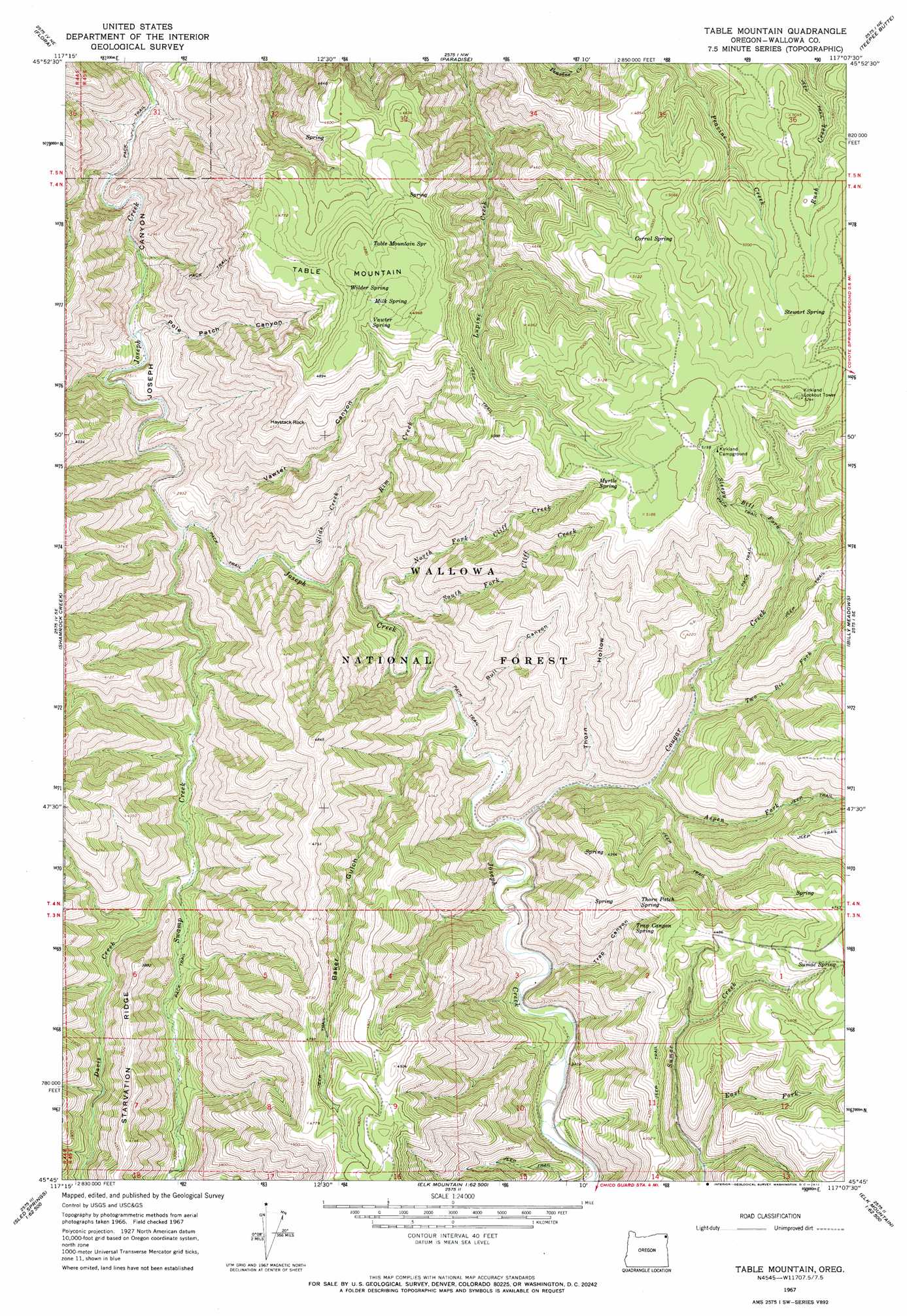
USGS Topo Quad 45117g2 - 1:24,000 scale
| Topo Map Name: | Table Mountain |
| USGS Topo Quad ID: | 45117g2 |
| Print Size: | ca. 21 1/4" wide x 27" high |
| Southeast Coordinates: | 45.75° N latitude / 117.125° W longitude |
| Map Center Coordinates: | 45.8125° N latitude / 117.1875° W longitude |
| U.S. State: | OR |
| Filename: | o45117g2.jpg |
| Download Map JPG Image: | Table Mountain topo map 1:24,000 scale |
| Map Type: | Topographic |
| Topo Series: | 7.5´ |
| Map Scale: | 1:24,000 |
| Source of Map Images: | United States Geological Survey (USGS) |
| Alternate Map Versions: |
Table Mountain OR 1967, updated 1971 Download PDF Buy paper map Table Mountain OR 1967, updated 1972 Download PDF Buy paper map Table Mountain OR 2011 Download PDF Buy paper map Table Mountain OR 2014 Download PDF Buy paper map |
| FStopo: | US Forest Service topo Table Mountain is available: Download FStopo PDF Download FStopo TIF |
1:24,000 Topo Quads surrounding Table Mountain
Saddle Butte |
Mountain View |
Fields Spring |
Black Butte |
Limekiln Rapids |
Troy |
Flora |
Paradise |
Teepee Butte |
Jim Creek Butte |
Wood Butte |
Shamrock Creek |
Table Mountain |
Billy Meadows |
Poison Point |
Washboard Ridge |
Sled Springs |
Starvation Ridge |
Greenwood Butte |
Zumwalt |
Evans |
Hicks Spring |
Elk Mountain |
Elk Mountain Se |
Findley Buttes |
> Back to 45117e1 at 1:100,000 scale
> Back to 45116a1 at 1:250,000 scale
> Back to U.S. Topo Maps home
Table Mountain topo map: Gazetteer
Table Mountain: Springs
Baker Spring elevation 1333m 4373′Corral Spring elevation 1502m 4927′
Driveway Spring elevation 1290m 4232′
Kirkland Spring elevation 1566m 5137′
Milk Spring elevation 1487m 4878′
Myrtle Spring elevation 1521m 4990′
Stewart Spring elevation 1545m 5068′
Sumac Spring elevation 1434m 4704′
Table Mountain Spring elevation 1474m 4835′
Thorn Patch Spring elevation 1276m 4186′
Trap Canyon Spring elevation 1230m 4035′
Vawter Spring elevation 1480m 4855′
Wilder Spring elevation 1486m 4875′
Table Mountain: Streams
Aspen Fork elevation 984m 3228′Cougar Creek elevation 896m 2939′
Davis Creek elevation 911m 2988′
East Fork Sumac Creek elevation 1121m 3677′
North Fork Cliff Creek elevation 855m 2805′
Rim Creek elevation 841m 2759′
Sleepy Bill Fork elevation 1262m 4140′
Slide Creek elevation 825m 2706′
South Fork Cliff Creek elevation 886m 2906′
Swamp Creek elevation 799m 2621′
Two Bit Fork elevation 1048m 3438′
Table Mountain: Summits
Haystack Rock elevation 1377m 4517′Miller Ridge elevation 1443m 4734′
Table Mountain elevation 1504m 4934′
Table Mountain: Valleys
Baker Gulch elevation 878m 2880′Pole Patch Canyon elevation 765m 2509′
Thorn Hollow elevation 948m 3110′
Trap Canyon elevation 937m 3074′
Vawter Canyon elevation 808m 2650′
Table Mountain digital topo map on disk
Buy this Table Mountain topo map showing relief, roads, GPS coordinates and other geographical features, as a high-resolution digital map file on DVD: