Wood Butte Topo Map Oregon
To zoom in, hover over the map of Wood Butte
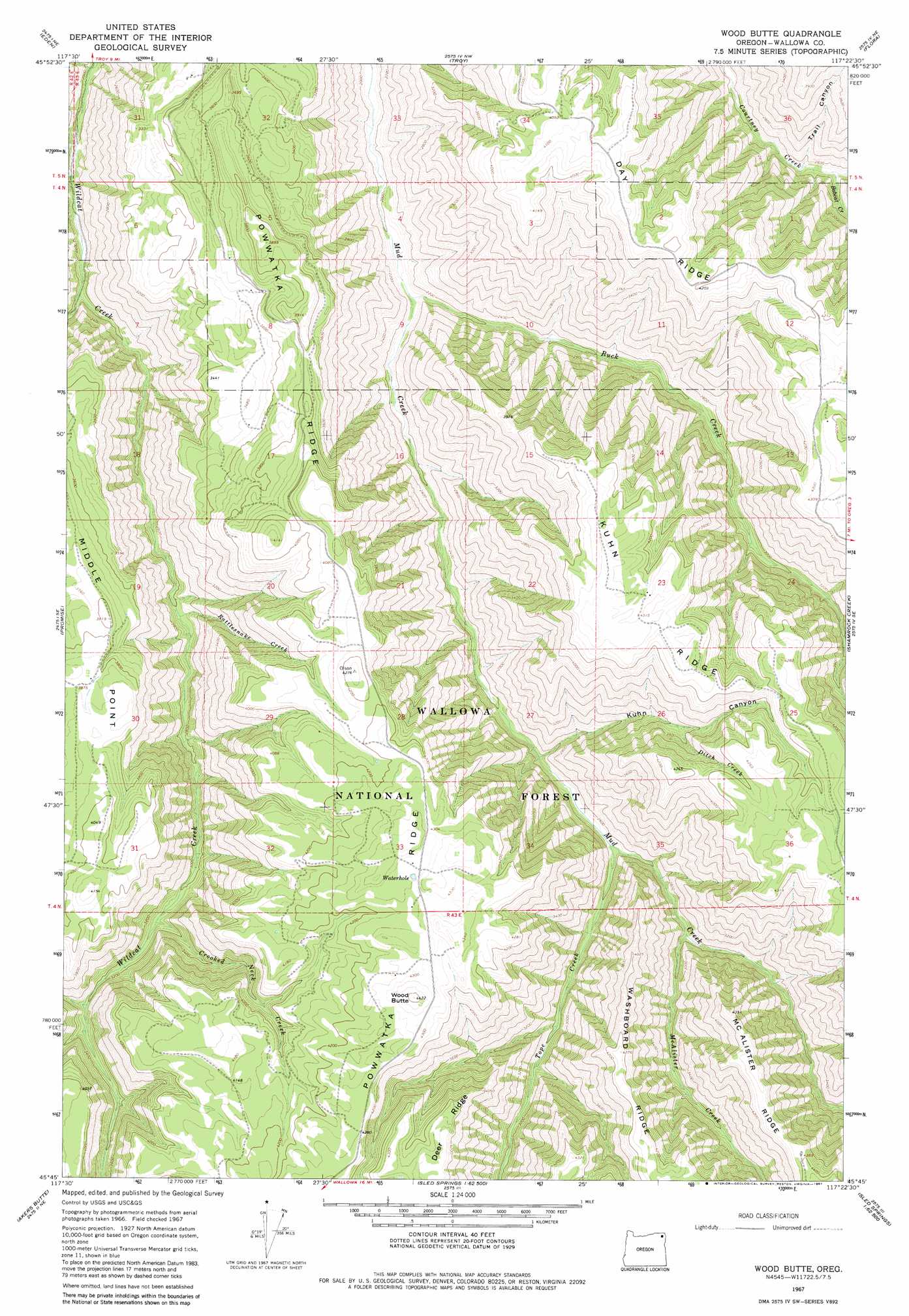
USGS Topo Quad 45117g4 - 1:24,000 scale
| Topo Map Name: | Wood Butte |
| USGS Topo Quad ID: | 45117g4 |
| Print Size: | ca. 21 1/4" wide x 27" high |
| Southeast Coordinates: | 45.75° N latitude / 117.375° W longitude |
| Map Center Coordinates: | 45.8125° N latitude / 117.4375° W longitude |
| U.S. State: | OR |
| Filename: | o45117g4.jpg |
| Download Map JPG Image: | Wood Butte topo map 1:24,000 scale |
| Map Type: | Topographic |
| Topo Series: | 7.5´ |
| Map Scale: | 1:24,000 |
| Source of Map Images: | United States Geological Survey (USGS) |
| Alternate Map Versions: |
Wood Butte OR 1967, updated 1971 Download PDF Buy paper map Wood Butte OR 1967, updated 1981 Download PDF Buy paper map Wood Butte OR 2011 Download PDF Buy paper map Wood Butte OR 2014 Download PDF Buy paper map |
| FStopo: | US Forest Service topo Wood Butte is available: Download FStopo PDF Download FStopo TIF |
1:24,000 Topo Quads surrounding Wood Butte
Oregon Butte |
Diamond Peak |
Saddle Butte |
Mountain View |
Fields Spring |
Elbow Creek |
Eden |
Troy |
Flora |
Paradise |
Deep Creek |
Promise |
Wood Butte |
Shamrock Creek |
Table Mountain |
Howard Butte |
Akers Butte |
Washboard Ridge |
Sled Springs |
Starvation Ridge |
Minam |
Wallowa |
Evans |
Hicks Spring |
Elk Mountain |
> Back to 45117e1 at 1:100,000 scale
> Back to 45116a1 at 1:250,000 scale
> Back to U.S. Topo Maps home
Wood Butte topo map: Gazetteer
Wood Butte: Airports
Powwatka Ridge Airstrip elevation 1037m 3402′Wood Butte: Reservoirs
Waterhole elevation 1306m 4284′Wood Butte: Ridges
Day Ridge elevation 1284m 4212′Kuhn Ridge elevation 1318m 4324′
Middle Point elevation 1161m 3809′
Wood Butte: Streams
Bobcat Creek elevation 765m 2509′Buck Creek elevation 630m 2066′
Crooked Neck Creek elevation 936m 3070′
Ditch Creek elevation 1053m 3454′
McAlister Creek elevation 826m 2709′
Rattlesnake Creek elevation 801m 2627′
Tope Creek elevation 774m 2539′
Wallupa Creek elevation 653m 2142′
Wood Butte: Summits
Wood Butte elevation 1345m 4412′Wood Butte: Valleys
Kuhn Canyon elevation 753m 2470′Trail Canyon elevation 771m 2529′
Wood Butte digital topo map on disk
Buy this Wood Butte topo map showing relief, roads, GPS coordinates and other geographical features, as a high-resolution digital map file on DVD: